Observation: Cascade Ridge

Observation Date
3/9/2026
Observer Name
Torrey & Slesser
Region
Provo » Cascade Ridge
Location Name or Route
South Fork
Weather
Sky
Few
Wind Direction
West
Wind Speed
Moderate
Weather Comments
Clear skies. Light winds below the ridge top. Moderate with occasional strong gusts at the ridge top. We did not observe any wind-drifted snow along our route, but we could see some plumes off Provo Peak where strong west winds were blowing.
Snow Characteristics
New Snow Depth
6"
New Snow Density
Medium
Snow Surface Conditions
Faceted Loose
Wind Crust
Melt-Freeze Crust
Damp
Snow Characteristics Comments

All but mid- and upper-elevation slopes facing NW-N-NE had been affected by the sun and warm temperatures. Recent storm snow remains soft and is beginning to facet. This was the weakest snow observed today, but it made for easy and fast travel.

Red Flags
Red Flags
Rapid Warming
Red Flags Comments
Temperatures warmed quickly this morning, especially at lower elevations, where the wind was not helping to keep snow surfaces warm. The snowpack became entirely unsupportable, and you could sink to the ground below 7500 feet.
Avalanche Problem #1
Problem
Wet Snow
Trend
Decreasing Danger
Problem #1 Comments

It was easy to initiate wet-loose avalanches on steep E and S facing slopes late morning as temperatures warmed with direct sun, specifically on slopes below the ridge top where the wind was not helping to keep the snow surfaces cool.

We also observed recent natural wet-loose avalanches in rocky, upper elevation east- and southeast-facing terrain.

Avalanche Problem #2
Problem
Persistent Weak Layer
Trend
Decreasing Danger
Problem #2 Comments

Where we traveled near the Cascade Ridge, we found 6-8 inches of recent settled storm snow that has begun to facet. Below the surface snow, we found a 12-inch-thick layer of crusts formed by recent rain and warm temperatures. The Dry January Facet layer was directly below this crust combination, was 4F+ hard and was rounding (gaining strength). It feels very unlikely a human could impact the weak layer below such a thick and strong crust. Other observations show different snowpack structures, so we know there is some variability in the snowpack, thickness of the crusts, and depth and strength of the weak layer.

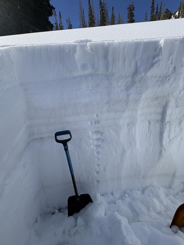
Northeast-facing slope at 9200 feet near Cascade Ridge. HS 160cm

Today's Observed Danger Rating
Moderate
Tomorrows Estimated Danger Rating
None
Coordinates