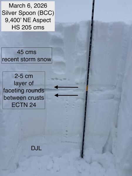
Travel was from the Spruces up through Greens Basin and Silver Spoon. The highest elevation we reached was 9,600 feet, with no wind transported snow noted. Storm snow instabilities settled out, and we could only get minimal sluffing on steep test slopes. Storm slab was well-bonded to the two buried rain/temperature crusts that formed this past week.
The weakest snow we found was a ~3 cm layer of faceted snow between the two crusts, with clean shears and ECTN24. This layering is now buried ~50 cms down from the snow surface. In areas that got more snow (LCC), the layering is obviously deeper.
The Dry January Layer (DJL) is buried over a meter deep, with a strong 1F/P hard slab above. The DJL is slowly gaining strength, and is now 4F- in hardness.
Given (1) the depth it is buried and (2) the strong slab above, it is becoming less likely you can trigger an avalanche on the DJL. My biggest concern for triggering an avalanche on this layer is in a thinner snowpack area (such as the Park City Ridgeline) or on a wind-loaded slope in steep, rocky terrain.
Photo below shows the layering of the snowpack from the surface down to the DJL.