Observation: East Side of Geyser Pass

Observation Date
3/1/2026
Observer Name
Trenbeath
Region
Moab » East Side of Geyser Pass
Location Name or Route
Geyser Bowl
Weather
Sky
Broken
Wind Direction
Southwest
Wind Speed
Light
Weather Comments
Yet another way too warm day in the mountains with temperatures in the mid to upper 40's at 10,000'.
Snow Characteristics
Snow Surface Conditions
Damp
Snow Characteristics Comments

The snow surface was damp everywhere I traveled today. Higher up I know that we have wind crusts and sastrugi, as well as dry, dense loose in sheltered locations. I did not get above 10,800'. Travel is mostly supportable as the storm snow from Feb 16-20 has settled into a cohesive soft slab 8"-10" thick that is now moist. Ski and snowmobile penetration is only about 2"-3" To step off of either, however, often results in near full depth foot penetration.

I observed runnels on the snow surface on both east and southwest aspects (they probably exist on west as well), and a puddle of standing water and some exposed bare ground at 10,600' near Geyser Pass.

Supportable travel for snowmobiles.

Runnels on an east aspect at 10,800'.

Puddle and exposed ground near Geyser Pass, 10,600'.

Red Flags
Red Flags
Rapid Warming
Poor Snowpack Structure
Red Flags Comments
I'm not sure I'd call it rapid, but it's been very warm during the days, sometimes without an overnight freeze; some nights with a partial freeze; and an occasional solid freeze. The snowpack structure remains poor with well preserved, dry faceted layers on northerly aspects, even at lower elevations, while easterly aspects are moist all the way through.
Avalanche Problem #1
Problem
Persistent Weak Layer
Problem #1 Comments

It remains possible to trigger an avalanche on the well preserved, February 11, faceted weak layer at all elevations on northerly aspects. An avalanche that fails there and then steps down is equally as likely. I ran an extended column test and produced a score of ECTP25 on the Feb 11 layer with an 18" thick slab on top. At higher elevations the slab is 2' thick or more. With the potential for a step down, avalanches up to 4' deep or more remain possible.

ECTP25 on the Feb 11, persistent weak layer.

Comments

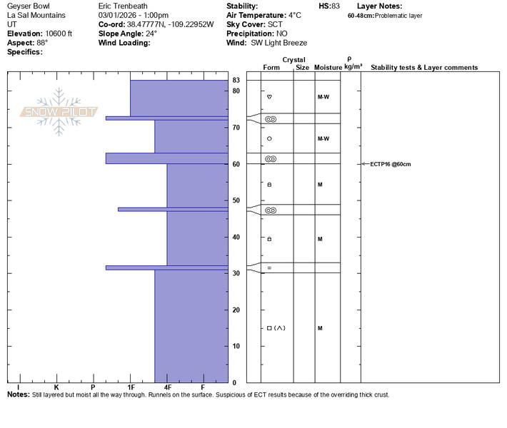
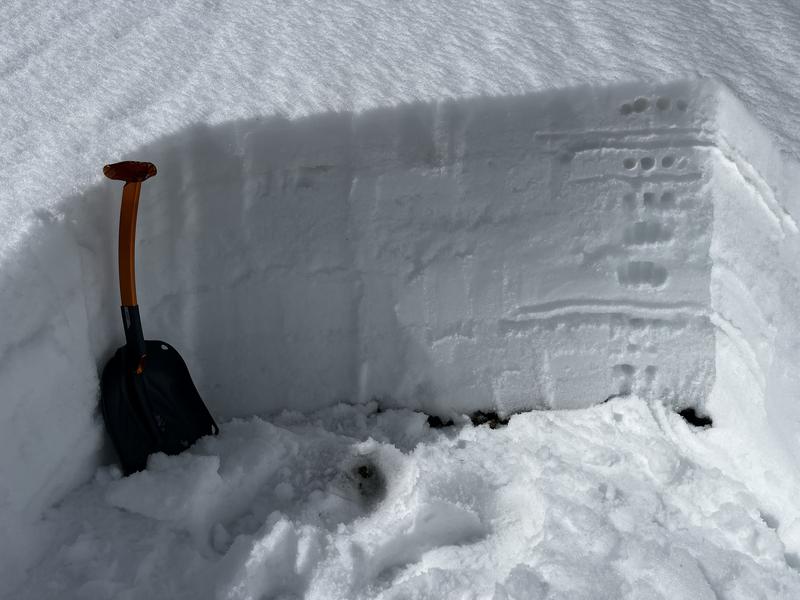
My objective for the day was to evaluate east and north aspects below treeline to see if the danger could be dropped to low. On northerly aspects, the answer was a clear no. The likelihood for triggering an avalanche is decreasing however. On east aspects, the answer is less clear. The snowpack is moist all the way through but still layered. I performed an extended column test with a score of ECTP16. I did, however, have to cut through a stout, 4cm melt-freeze crust for failure to occur on a layer of moist facets beneath so I don't think the weight of a skier would affect it. More concerning, is the trend toward an isothermal snowpack but a return to cooler nighttime temperatures this week should keep that at bay.

Moist, layered snowpack on an east aspect at 10,800'.

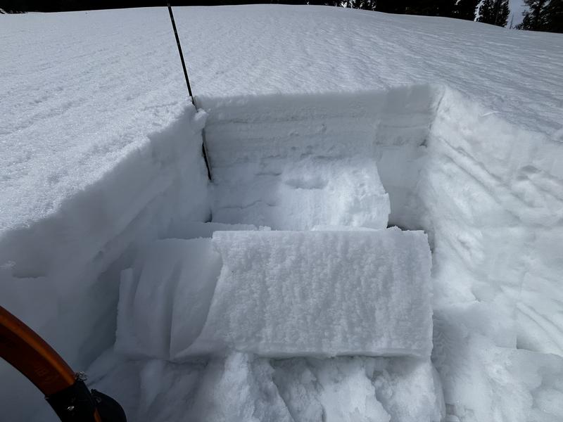
ECTP16 on moist facets beneath a stout crust.

Today's Observed Danger Rating
Considerable
Coordinates