Observation: Twin Lakes Pass

Observation Date
2/24/2026
Observer Name
Champion, Antenucci, Munson
Region
Salt Lake » Big Cottonwood Canyon » Twin Lakes Pass
Location Name or Route
Twin Lakes Pass
Weather
Sky
Obscured
Precipitation
Light Snowfall
Wind Direction
West
Wind Speed
Moderate
Weather Comments
Well, should I describe it as a wintry mix? At times, what was falling out of the sky was dry and white, but during other periods it came down more as rain and snow, with some ice pellets mixed in. Winds were primarily moderate, with strong gusts along ridgelines. Snow was moving.
Snow Characteristics
Snow Surface Conditions
Powder
Dense Loose
Wind Crust
Melt-Freeze Crust
Damp
Snow Characteristics Comments

Snow texture varied quickly. Out of the lot, things were fairly damp or firm once frozen, but temperatures had climbed above the threshold for a true melt freeze crust where we traveled. As we moved up toward Twins Lake Pass, the snow surface showed many signs of high winds, including textured sastrugi and wind rolls, in places covering the generally beat in skin track. Once we reached Twins Lake Pass, it was possible to find a few soft, powdery turns and some dense loose snow. Not much true powder, but still enjoyable. Shift aspect at all, though, and the snow became much heavier or had a slight zipper crust on the surface.

Just a few overall coverage photos:

Red Flags
Red Flags
Wind Loading
Poor Snowpack Structure
Red Flags Comments
Drifting snow down to even the mid-elevations. Poor snowpack structure still very much exists.
Avalanche Problem #1
Problem
Persistent Weak Layer
Trend
Increasing Danger
Problem #1 Comments

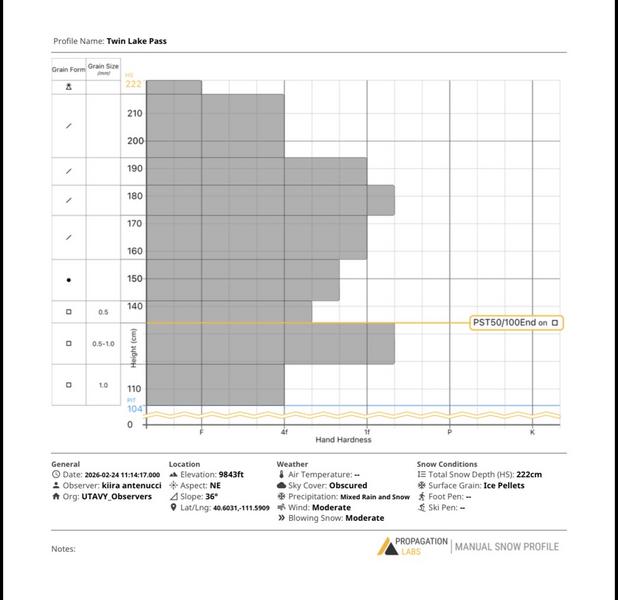
The primary focus of the day was to look at the snow surfaces and what this storm will be falling on, and to continue monitoring the persistent weak layer. We dug a pit on a NE aspect near 9,800 feet off Twin Lakes Pass. Total snow depth was 222 cm, and we dug just below the facets, not all the way down to the CERC.

We found what I have been seeing across most of the Upper Cottonwoods: new snow from the past two storm systems sitting atop weak faceted snow. The primary pattern in the Upper Cottonwoods has been a slightly firmer band of faceted snow near the new snow interface, above 1F hardness, with weaker snow both above and below it. This does not mirror what I have consistently seen along the Park City ridgeline and more outlying features, where the new snow sits directly on consistently weak faceted snow, F minus or weaker.

With the slightly firmer faceted snow and the overall depth of the new snow, we were unable to get propagation in our pit, producing an ECTX. However, using a PST in the slightly weaker snow above the 1F faceted layer, we got PST 50/100 END down on the facets. I think this helps represent what to pay attention to moving forward. We may not see as much propagation in our pits, but the propagation propensity still exists once that weak layer is removed or an additional load is added, as we will see with this next storm and its higher water totals.

Pit profile - Twin Lake Pass - NE Aspect - 9990'

Video
Today's Observed Danger Rating
Considerable
Tomorrows Estimated Danger Rating
High
Coordinates