Forecast for the Skyline Area Mountains

Issued by Brett Kobernik on
Thursday morning, December 12, 2019
Thursday morning, December 12, 2019
EXPECT THE AVALANCHE DANGER TO INCREASE THIS WEEKEND WITH A SNOWY AND VERY WINDY STORM EXPECTED.
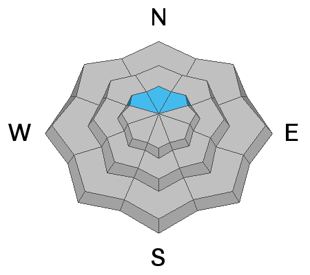
For today, the overall avalanche danger is MODERATE. By far the biggest concern is on slopes approaching 40 degrees above about 9000 feet that face northwest, north, and northeast where an avalanche could break into old weak sugar snow near the ground.

Low
Moderate
Considerable
High
Extreme
Learn how to read the forecast here
 Weather and Snow
The snow surface has weakened some over the last few days. It is turning into small grained facets (sugar snow). Currently, this is not an issue but it's possible it might be when it gets buried with the next storm. We will watch this interface closely once it's buried. See this great backcountry observation from Darce Trotter who describes the situation.
The next storm will start to move in late today and will last into Saturday with periods of snow in a westerly flow. Temperatures will range from the mid 20s down to the upper teens. The wind looks like it's going to be strong! The weather models have been trending higher on total snow amounts over the last few days. I'm thinking we should see about a foot of snow by the end of the storm. It's possible we might see a bit more.
Avalanche Problem #1
Persistent Weak Layer
Type
Location

Likelihood
Size
Description
USE CAUTION THIS WEEKEND AS THE SNOWPACK GETS LOADED WITH NEW SNOW!! High elevation slopes approaching 40 degrees that face northwest, north and northeast should be avoided because they are holding weak sugar snow near the ground that could collapse and avalanche.
Additional Information
This forecast is from the U.S. Forest Service, which is solely responsible for its content. This forecast describes general avalanche conditions and local variations always occur.


