

Forecast for the Uintas Area Mountains

Issued by Craig Gordon on
Thursday morning, December 12, 2019
Thursday morning, December 12, 2019
HEADS UP... expect a rising avalanche danger the next few days as a robust storm system materializes over the region.
For today-
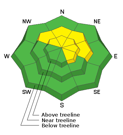
In the wind zone at upper elevations, MODERATE avalanche danger exists on upper elevation slopes facing the north half of the compass. Human triggered avalanches are POSSIBLE, particularly on steep, rocky slopes harboring weak, pre-existing, early season snow near the ground. Remember- any avalanche that breaks to old snow near the ground may quickly get out of hand, resulting in a deep and dangerous slide.
Along the leeward side of mid and upper elevation ridges and around terrain features like chutes and gullies, you'll find a MODERATE avalanche danger. Human triggered avalanches breaking within recently formed wind drifts are possible. As winds blow and snow stacks up later today, fresh drifts may break a little deeper and wider than you might expect.
Here's your exit strategy-
Wind sheltered low elevation terrain that held no old snow prior to the Thanksgiving storm generally offers LOW avalanche danger and human triggered avalanches are unlikely. South facing terrain and big open meadows with no steep terrain above or adjacent to where you're riding are the ticket.
Low
Moderate
Considerable
High
Extreme
Learn how to read the forecast here
 Special Announcements

Please join me on Friday Dec. 13th at 6:30 for a free avalanche awareness presentation in partnership with Wasatch County SAR. It's guaranteed to be entertaining, informative, and I'll share safety tips that allow you to rip powder safely and come home to your families at the end of the day.... pretty good deal... huh?
 Weather and Snow
This morning-
Clouds thickened overnight, a trace of new snow dusted the high peaks, and temperatures hover in the mid 20's. Southerly winds ramped up early this morning, currently blowing 25-35 mph along the high ridges. Of course, all of this is a precursor to a stormy pattern headed our way beginning tonight and lingering into the early portion of the weekend. The range is generally white and overall coverage quite good, especially in the high country where total snow depths average just under three feet.
Future cast-
Our good friend at the National Weather Service, Brian McInerney, compiled the detailed weather briefing above, clearing illustrating the upcoming storm.
 Recent Avalanches
No new avalanches to report from the eastern front.
Recent avalanche activity and trip reports are found here.

Avalanche Problem #1
Persistent Weak Layer
Type
Location

Likelihood
Size
Description
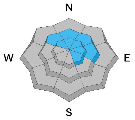
We've got a series of storms headed our way and this may be enough additional weight needed to wake up our problem child, a persistent weak layer of snow, now buried close to the ground in our early season snowpack. And while it's been over a week since we've heard from this layer of snow, in reality little has changed on this front and that's why it's call "persistent". You see, anything "persistent" in a snowpack takes a long time to heal and that's where it gets a little tricky. As the weak layers grow slightly stronger and get comfortable in their own skin, you can ride some steep slopes, often without incident, giving us a false sense of snowpack stability. However, all we need to do is find one weakness, maybe around a bush or rock that we can't see buried underneath the snow, collapse the pack, and now we're staring down the barrel of a scary avalanche. The way I'm avoiding this scenario is by simply avoiding the terrain where this setup exists- steep, upper elevation, north facing slopes that harbored snow prior to the big Thanksgiving storm. With plenty of safe options, there's no reason to pull on the avalanche dragons tail.
But wait... here's the good news. There's a lot of terrain to ride today and not have to deal with unmanageable avalanche conditions, IF you chose slopes that had NO old snow prior to the big Thanksgiving storm.
But wait... here's the good news. There's a lot of terrain to ride today and not have to deal with unmanageable avalanche conditions, IF you chose slopes that had NO old snow prior to the big Thanksgiving storm.
Welcome back!
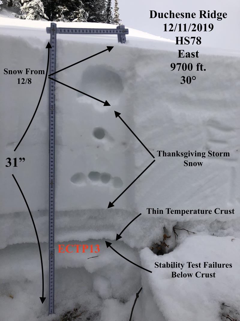
JG was near the Duchesne Ridge yesterday and his beautifully detailed pit profile above clearly shows our current setup. Click here to view more on JG's travels and to read his very sage advice.
Meanwhile, I was on the North Slope on Tuesday and though my snowpit stability tests suggest a strengthening snowpack (good news), failures continue to revolve around weak, basal snow (bad news). What this means is... it might be harder to initiate a slide, but the piece of snow you trigger will dangerously break to the ground.

Knowing where the weak snow exists is the ticket. Taking our own advice, Tuesday my partner and I simply steered clear of upper elevation, shady slopes facing the north half of the compass, got out on sunny slopes with no old snow, and still had a blast.
Avalanche Problem #2
Wind Drifted Snow
Type
Location
Likelihood
Size
Description
As the storm develops, we can expect drifting along the leeward of upper elevation ridges and around terrain features like chutes and gullies. As snow stacks up and winds continue blowing, fresh drifts may break slightly wider and deeper than you might expect, especially by days end. Your best bet for avoidance is to simply steer clear of any fat, rounded piece of snow, especially if it looks chalky or sounds hollow like a drum. In addition, look for and listen to clues like whoomphing sounds or shooting cracks in the snow which are sure signs of unstable conditions.
Additional Information
Thanks to the generous support of our Utah ski resorts and Ski Utah, we have discount lift tickets available. All proceeds support the UAC. Get your tickets HERE.
Get one of these cool t-shirts to support the UAC and other avalanche centers across the U.S. INFO
NEW Blog Post - Speeding - A Drift Into Failure Story
General Announcements
The information in this forecast expires in 24 hours, but will be updated by 7:30 AM Friday Dec. 13th.
This forecast is updated daily by 7:30 AM.
In the mean-time, if you see or trigger an avalanche or just wanna let me know what you're seeing you can reach me directly at 801-231-2170
It'll be a minute or two before we're riding, but while you're waiting....
This is a great time of year to schedule one of our free avy awareness presentations.
You can email me directly [email protected]
The information in this forecast is from the US Forest Service which is solely responsible for its content.