

Forecast for the Uintas Area Mountains

Issued by Craig Gordon on
Saturday morning, December 12, 2020
Saturday morning, December 12, 2020
Heads up... look for a rising avalanche danger throughout the day as new snow stacks up.
As today's storm materializes and new snow piles up on weak, pre-existing surface snow, it'll get touchy out there and you can expect the avalanche danger to rise to MODERATE. Human triggered avalanches become possible, especially in the wind zone on steep, leeward, upper elevation slopes facing the north half of the compass.
Remember- shallow snow cover and low tide conditions barely hide natural obstacles like stumps and rocks. Triggering even a small slide can lead to an instant buzz-kill and a season ending injury.
Low
Moderate
Considerable
High
Extreme
Learn how to read the forecast here
 Special Announcements
This week is the 2nd Annual Avalanche Awareness Week. We will be hosting avalanche awareness and education events across the state of Utah. Get a full schedule of events here.
The holiday season is right around the corner!! Looking for that special something for your partner? or yourself?
Well, we've got an easy shopping solution for you. Buy your gifts at our Pray for Snow online auction.
Well, we've got an easy shopping solution for you. Buy your gifts at our Pray for Snow online auction.
If you missed the 13th Annual Utah Snow and Avalanche Workshop, the recordings are available for purchase from the UAC Store. Click here for more details.
Looking for ways to navigate through an unusual winter? Please visit this website with information about Responsible Winter Recreation by the Utah Office of Outdoor Recreation
 Weather and Snow
Nowcast-
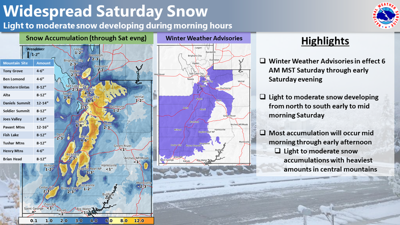
As illustrated in the image below, a good shot of snow is on our doorstep, slated to arrive in the next few hours. In the mean-time, clouds drape the mountains and light snow is just starting to fall. In addition, it's cold with temperatures registering in the single digits and low teens. Southwest winds bumped into the 20's and 30's along the high peaks right around midnight, but have since calmed down and currently blow 15-20 mph. Riding and turning conditions are hit or miss and if you have projects to do, get them off your plate this morning and wait for more snow to stack up.
Forecast-
A cold storm system pushes through the region today, bringing a quick hitting round of snow to our zone. The bulk of the snow is expected to fall through the morning hours, with brief periods of moderate to heavy snowfall possible before noon. Not a huge storm, but 6"-10" looks to be a good bet by the time things wind down late in the day. West and northwest winds bump into the 30's and 40's along the high peaks as the storm slides through our region. Temperatures will be much colder with highs only reaching into the teens. Skies clear late tonight and overnight lows crash to near zero.
Futurecast-
A break in the action is on tap for Sunday with another system slated for early next week.
Looking for real-time temps, snow, or wind?
Click here and then on the "western Uinta" tab for western Uinta specific, weather station network.
 Recent Avalanches
No new avalanche activity to report.
To view trip reports and recent avalanche activity, simply click here.

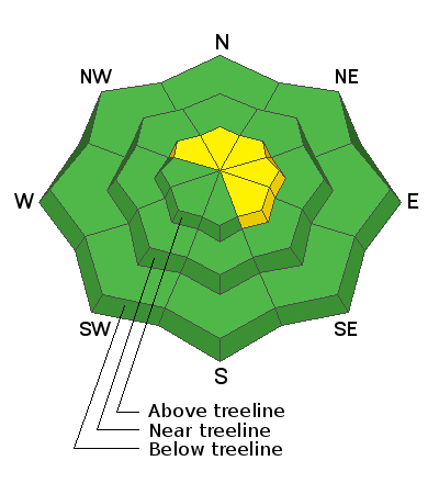
Avalanche Problem #1
Wind Drifted Snow
Type
Location
Likelihood
Size
Description
Our main man Ted Scroggin was near Bald Mountain and Reids Peak eralier this week and put together an excellent viddy illustrating the current state of our snowpack.
It's been a long, dry spell, but we know it always snows in Utah and it looks like a pattern shift is on the doorstep this morning. The good news is... snow is on the way and it's gonna bring a welcome coat of white paint to our mountains. The bad news is... the snowpack grew very weak and sugary the past few weeks and now it's strength is gonna be tested. This isn't a blockbuster storm and the snowpack isn't going to come unglued, but I do think the new snow with a little bit of wind will create fresh drifts sensitive to our additional weight. Found on steep, leeward slopes in the wind zone, it's an easy and mostly manageable avalanche problem to avoid. Simply steer clear of any fat, rounded piece of snow, particularly if it sounds hollow like a drum. And remember... our snowpack is super shallow and triggering even a small slide can take you for a body-bruising ride through rocks and stumps barely hidden under the thin snowpack.
Avalanche Problem #2
New Snow
Type
Location

Likelihood
Size
Description
There's a myriad of old snow surfaces... from windboard, to suncrusts, to plain old, weak surface surface snow and that'll allow for sluffing on steep, sustained slopes. Easy to manage through avoidance and not a big deal until the new snow slams you into a tree or buries you in a terrain trap like a gully. So... if you're headed out to cut a Christmas tree or for a family sleigh adventure, think about the terrain you're traveling in and avoid being on or under steep snow covered slopes.
Additional Information
Last week we installed a snow study site near Camp Steiner and it's up and running! Click HERE real-time snow fall, total snow depth, and current temperatures. This data fills in a big black hole of snow information near Mirror Lake. I'd like to give a big shout out to Sean and Jesse from the NWS along with Ted Scroggin, our main man in the Uinta's... the entire crew is featured in the viddy above.
I'll update this forecast by 7:00 AM tomorrow, Sunday December 13th.
Your observations are import, so please let me know what you're seeing... click HERE and contribute to this amazing community based program
Information on outdoor recreation - The State of Utah created this webpage with information about recreating on both state and federal public lands during the current health crisis.
Skiing and riding at closed ski resorts - Some resorts allow access now, and some do not. Please check HERE for the latest info on ski area access.
New to the backcountry (including riding at closed resorts) - Watch the award-winning, 15 minute Know Before You Go video, or take the 5-part, free online-learning series.
General Announcements
If you see or trigger an avalanche or just wanna let me know what you're seeing you can reach me directly at 801-231-2170 or [email protected]
The information in this forecast is from the US Forest Service which is solely responsible for its content.