Forecast for the Uintas Area Mountains

Craig Gordon
Issued by Craig Gordon on
Sunday morning, December 13, 2020
In the wind zone, at and above treeline, pockets of MODERATE avalanche danger are found on steep, wind drifted slopes. While not widespread, human triggered avalanches are POSSIBLE, especially in terrain with a southerly component to its aspect.
Remember- shallow snow cover and low tide conditions barely hide natural obstacles like stumps and rocks. Triggering even a small slide can lead to an instant buzz-kill and a season ending injury.
Low
Moderate
Considerable
High
Extreme
Learn how to read the forecast here
Special Announcements
This week is the 2nd Annual Avalanche Awareness Week. We will be hosting avalanche awareness and education events across the state of Utah. Get a full schedule of events here.
The holiday season is right around the corner!! Looking for that special something for your partner? or yourself?
Well, we've got an easy shopping solution for you. Buy your gifts at our Pray for Snow online auction.
If you missed the 13th Annual Utah Snow and Avalanche Workshop, the recordings are available for purchase from the UAC Store. Click here for more details.
Looking for ways to navigate through an unusual winter? Please visit this website with information about Responsible Winter Recreation by the Utah Office of Outdoor Recreation
Weather and Snow
Nowcast-
Yesterday's storm was a bit of an under-performer, yet still delivered 4" of light density ultra-fluff across the range. Skies cleared overnight, and dang... the bottom drop out of the thermometer with temperatures registering near zero. Add in northerly winds blowing 10-20 mph and windchill values clock in at nearly -20 degrees along the high peaks... ouch! And whilst the new snow is welcome news, total snow depths throughout the range average just 12"-18", so the Uinta's are still quite thin and travel is sorta limited to road rides and grassy slopes.
Forecast-
It'll be a stunning day in the mountains. Expect mostly sunny skies early in the day, with temperatures climbing into the 20's. Northerly winds switch to the west and southwest and increase into the 20's and 30's late in the day. Clouds stream into the region this evening and light snow develops overnight.
Futurecast-
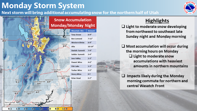
A good shot of snow materializes Monday and continues overnight with 6"-10" expected by days end Tuesday. A break in the action is on tap for late Tuesday through Wednesday, before our next storm system sets course for the area by Thursday.
Looking for real-time temps, snow, or wind?
Click here and then on the "western Uinta" tab for western Uinta specific, weather station network.
Recent Avalanches
Yesterday's new snow sluffed easily on steep slopes, running faster and further than you might expect.
To view trip reports and recent avalanche activity, simply click here.
Ad
Avalanche Problem #1
Wind Drifted Snow
Type
Location
Likelihood
Size
Description
It didn't take much wind to whip yesterday's light density storm snow into fresh wind drifts, reactive to the additional weight of a rider. And while the vast majority of these settled out overnight, I bet there's a lingering drift or two that could still crack out around you today. The good news... it's an easy and mostly manageable avalanche problem to avoid. Found on steep, leeward slopes in the wind zone, simply steer clear of any fat, rounded piece of snow, particularly if it sounds hollow like a drum. And remember... our snowpack is super shallow and triggering even a small slide can take you for a body-bruising ride through rocks and stumps barely hidden under the thin snowpack.
Avalanche Problem #2
New Snow
Type
Location
Likelihood
Size
Description
There's a myriad of old snow surfaces... from windboard, to suncrusts, to plain old, weak surface surface snow and that'll allow for sluffing on steep, sustained slopes. Easy to manage through avoidance and not a big deal until the new snow slams you into a tree or buries you in a terrain trap like a gully. So... if you're headed out to cut a Christmas tree or for a family sleigh adventure, think about the terrain you're traveling in and avoid being on or under steep snow covered slopes.
Additional Information
Last week we installed a snow study site near Camp Steiner and it's up and running! Click HERE real-time snow fall, total snow depth, and current temperatures. This data fills in a big black hole of snow information near Mirror Lake. I'd like to give a big shout out to Sean and Jesse from the NWS along with Ted Scroggin, our main man in the Uinta's... the entire crew is featured in the viddy above.
I'll update this forecast by 7:00 AM tomorrow, Monday December 14th.
Your observations are import, so please let me know what you're seeing... click HERE and contribute to this amazing community based program
Information on outdoor recreation - The State of Utah created this webpage with information about recreating on both state and federal public lands during the current health crisis.

Skiing and riding at closed ski resorts - Some resorts allow access now, and some do not. Please check HERE for the latest info on ski area access.

New to the backcountry (including riding at closed resorts) - Watch the award-winning, 15 minute Know Before You Go video, or take the 5-part, free online-learning series.
General Announcements
If you see or trigger an avalanche or just wanna let me know what you're seeing you can reach me directly at 801-231-2170 or [email protected]
The information in this forecast is from the US Forest Service which is solely responsible for its content.