March Kicks Off Our Spring Campaign- Donate Now to Support Forecasting

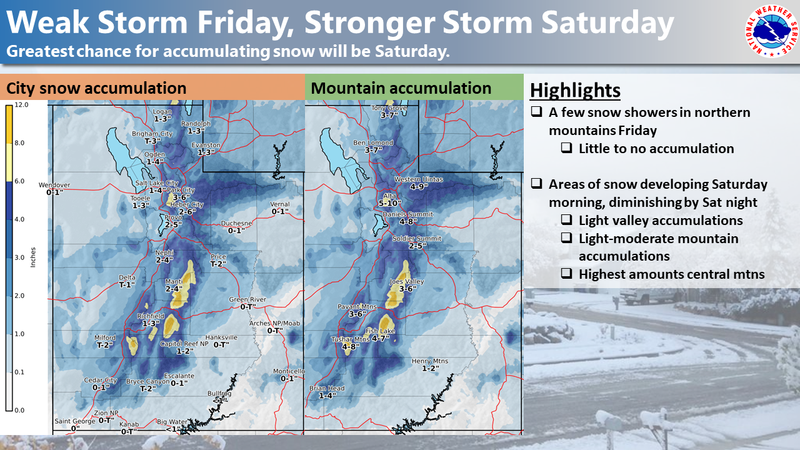
Forecast for the Uintas Area Mountains

Craig Gordon
Issued by Craig Gordon on
Friday morning, December 11, 2020
Heads up... the avalanche danger may rise significantly in the next 24-48 hours.
For today though, the avalanche danger is generally LOW and human triggered avalanches are unlikely. Shallow snow cover and low tide conditions suggest the biggest threat is slamming into a season ending obstacle like a tree stump, barely hidden under the surface of our thin, early season snowpack.
Low
Moderate
Considerable
High
Extreme
Learn how to read the forecast here
Special Announcements
This week is the 2nd Annual Avalanche Awareness Week. We will be hosting avalanche awareness and education events across the state of Utah. Get a full schedule of events here.
The holiday season is right around the corner!! Looking for that special something for your partner? or yourself?
Well, we've got an easy shopping solution for you. Buy your gifts at our Pray for Snow online auction.
If you missed the 13th Annual Utah Snow and Avalanche Workshop, the recordings are available for purchase from the UAC Store. Click here for more details.
Looking for ways to navigate through an unusual winter? Please visit this website with information about Responsible Winter Recreation by the Utah Office of Outdoor Recreation
Weather and Snow
Is it soup yet? Thanks to photographer extraordinaire, Christian Rouse for snapping this image, whilst trail running above the valley gunk Wednesday.
Nowcast-
A weak disturbance sliding through the region overnight, delivered a trace to a couple traces of snow. Under mostly cloudy skies, temperatures register in the teens and low 20's. West and southwest winds increased right around 2:00 this morning and currently blow 25-35 mph along the high ridges. Look for another round of light mountain snow showers with little accumulation. It's a good day to get projects done and wait 'til the main storm event arrives tomorrow as riding and turning conditions are a mixed bag.
Forecast-
A good shot of snow develops Saturday morning with the majority of the snowfall stacking up during the mid morning to early afternoon hours. Not a huge storm, but 6"-10" looks to be a good bet by the time things wind down late in the day. Temperatures will be much colder with highs only reaching into the teens.
Futurecast-
A break in the action is on tap for Sunday with another system slated for early next week.
Looking for real-time temps, snow, or wind?
Click here and then on the "western Uinta" tab for western Uinta specific, weather station network.
Recent Avalanches
No new avalanche activity to report.
To view trip reports and recent avalanche activity, simply click here.
Ad
Avalanche Problem #1
Normal Caution
Type
Location
Likelihood
Size
Description
Our main man Ted Scroggin was near Bald Mountain and Reids Peak ealier this week and put together an excellent viddy illustrating the current state of our snowpack.
It's been a long, dry spell, but we know it always snows in Utah and it looks like a pattern shift is on the doorstep for the weekend. So... while the riding and turning conditions are a bit underwhelming, you can start prepping by getting out on the snow and create a visual map of our snow cover... where snow exists, how weak is it, and what is the distribution? By creating either a cerebral or image-based map, you'll have this dialed in once the winter switch gets turned on and you'll know the type of terrain to avoid (hint... steep, upper elevation slopes facing the north half of the compass) and those you can ride safely (answer... slopes facing the south half of the compass with no pre-existing snow)... done and done.
For today, the avalanche hazard is generally LOW and you'd really have to go out of your way to find an avalanche today. However, the Uinta's are a big place and there may be a shallow, fresh wind drift that reacts to our additional weight. So, look for and avoid any fat, rounded piece of snow, tone it down, take it slow and remember- it's a long season and you definitely don't want to instantly end it before things get going.
Additional Information
Last week we installed a snow study site near Camp Steiner and it's up and running! Click HERE real-time snow fall, total snow depth, and current temperatures. This data fills in a big black hole of snow information near Mirror Lake. I'd like to give a big shout out to Sean and Jesse from the NWS along with Ted Scroggin, our main man in the Uinta's... the entire crew is featured in the viddy above.
I'll update this forecast by 7:00 AM tomorrow, Saturday December 12th.
Your observations are import, so please let me know what you're seeing... click HERE and contribute to this amazing community based program
Information on outdoor recreation - The State of Utah created this webpage with information about recreating on both state and federal public lands during the current health crisis.

Skiing and riding at closed ski resorts - Some resorts allow access now, and some do not. Please check HERE for the latest info on ski area access.

New to the backcountry (including riding at closed resorts) - Watch the award-winning, 15 minute Know Before You Go video, or take the 5-part, free online-learning series.
General Announcements
If you see or trigger an avalanche or just wanna let me know what you're seeing you can reach me directly at 801-231-2170 or [email protected]
The information in this forecast is from the US Forest Service which is solely responsible for its content.