
Forecast for the Uintas Area Mountains

Issued by Craig Gordon on
Thursday morning, March 9, 2023
Thursday morning, March 9, 2023
Heads up.... avalanche danger rises significantly overnight as a powerful storm sets its sights on the region-
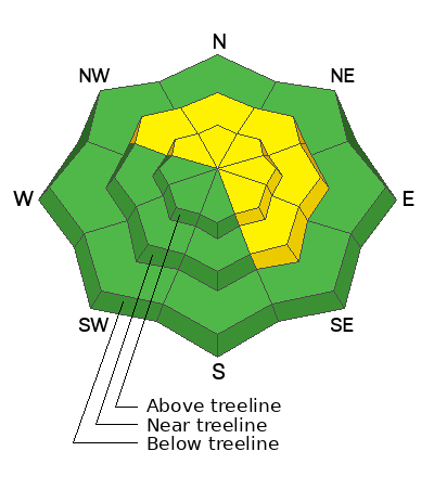
For today, MODERATE avalanche danger dots steep, upper elevation leeward slopes at and above treeline. Human triggered avalanches are POSSIBLE, especially in the wind zone on drifted terrain facing the north half of the compass, and particularly on slopes with an easterly component to its aspect. With several layers of wind drifted snow, there's enough there... there, to catch you by surprise and knock you off your feet.
If you're looking for LOW avalanche danger you came to the right place. Simply steer your snow riding vehicle toward mid and low elevation terrain, especially slopes facing the south half of the compass where human triggered avalanches are UNLIKELY.
Low
Moderate
Considerable
High
Extreme
Learn how to read the forecast here
 Special Announcements
To help you safely enjoy the backcountry, the UAC team is constantly evaluating and implementing new programs and technologies. Donate to the Spring Campaign to help our team implement innovative tools and better provide you
 Weather and Snow
Nowcast- From Mirror Lake to Strawberry, the south half of the range benefited from a nice shot of snow overnight. It looks like 6" snow with about .30 H2O is the norm, while the North Slope lags behind by a couple inches. In either case, west and southwest winds blow 15-25 mph and temperatures are in the teens and low 20's. No matter where you go... riding and turning conditions are all-time.
Forecast- Grab the break in the weather while you can. Clearing skies in the next couple hours, deliver a spectacular morning with high temperatures climbing into the low 30's. Clouds march into the eastern front late in the day and southwest winds crank into the 50's by dinnertime.
Futurecast- A pattern shift early Friday ushers in an Atmospheric River that camps out through the weekend, producing big water, wind, and snow. A few feet of snow with a couple inches of water seem like a good bet by late Sunday.
Detailed trip reports and recent obs are found HERE.
 Recent Avalanches
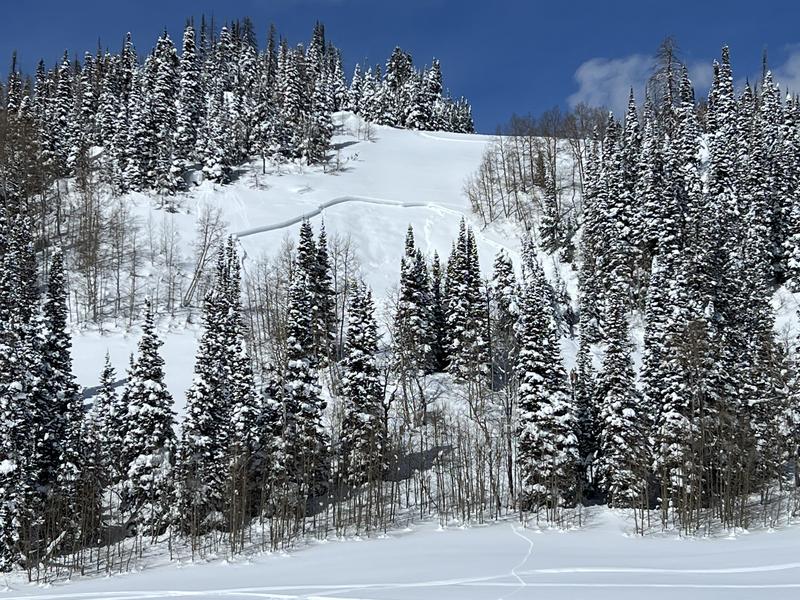
Remotely triggered yesterday in Mill Hollow, a small pocket on a southeast facing slope at 9,400'. The heads up here is a trend that mimics the Wasatch from earlier this week. I often think southeast aspects in the Uinta's have a little more polar, than solar to their snow structure and with a robust storm to round out the work week, we might wanna keep an eye on this aspect.
Otherwise, a quiet day on the eastern front yesterday, but plenty of avy activity to peruse if ya wanna geek out... click HERE to track this years slide activity throughout the range.

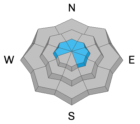
Avalanche Problem #1
Wind Drifted Snow
Type
Location
Likelihood
Size
Description
Ominous overhanging cornice coupled with a recent wind run from Windy Peak are clues to both recent and older wind loading events. It'll also give us an idea where we might find a wind drift, reactive to our additional weight on steep, leeward slopes.
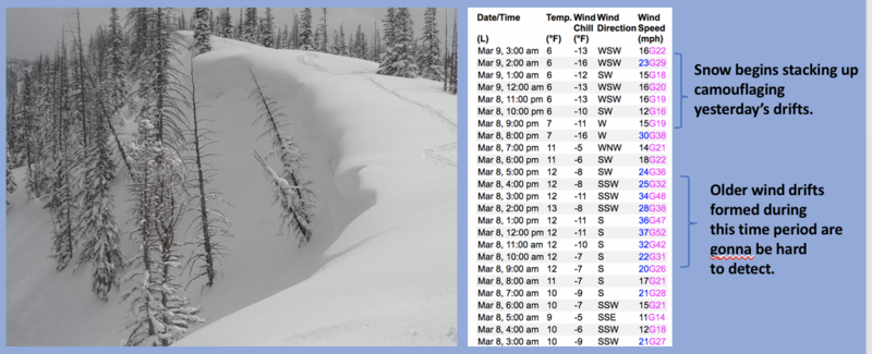
Last nights storm snow conspires with recent winds, whipping up a fresh batch of drifts sensitive to our additional weight. Adding a twist to the avalanche recipe... wind drifts formed yesterday are now hidden by today's fresh snow, making them harder to detect. So, let's break it down and keep it simple... steep, wind drifted slopes facing the north half of the compass is bulls-eye terrain and today's avalanches will break deeper and wider than you might expect. In addition, with several layers of storm snow to work with there's enough volume to knock to off your feet. If your objective is tagging sustained steep terrain, consider the consequences of triggering a slide and have an exit strategy in place. Better yet, tweak small test slopes like road banks with characteristics similar to what you wanna ride and see how they're reacting to your additional weight, before blindly center punching a big, committing line. No mystery here as this avalanche dragon is straight-forward and easy to avoid. Lose the wind and you lose the problem.
Additional Information
Weather stations-
And... rime events from January's atmospheric rivers severely crippled the Uinta weather station network. I'm working to get it back up and running, but a few stations are found HERE (click weather stations, and then on the Western Uinta tab)
Observations-
Your observations are important, so please let me know what you're seeing... click HERE and contribute to this amazing community-based program
General Announcements
Issued at 03:23 on Thursday March 9th this forecast expires 24 hours after the date and time posted, but will be updated by 07:00 Friday March 10th 2023.
Before it gets too crazy, now is the time to book an avalanche awareness presentation for your group, club, or posse. You can reach Craig directly at 801-231-2170 or [email protected].
This forecast is from the U.S.D.A. Forest Service, which is solely responsible for its content. This forecast describes general avalanche conditions and local variations always occur.