

Nikki Champion
Forecaster
Week in Review: Avalanche Conditions and Snowpack Developments (March 7-March 13, 2025)
Each week, we look back at the key snowfall, weather, and avalanche events from the previous week. For archived forecasts, visit the Salt Lake Mountains’ past updates.

Overall Summary:
It was a dynamic week in the Wasatch, with shifting avalanche conditions driven by new snowfall, buried weak layers, and warming temperatures. The week started with a storm cycle that dropped 1–2 feet of snow, forming reactive storm slabs and wind-drifted snow, especially at mid and upper elevations. Avalanche danger remained CONSIDERABLE in steep terrain, with human-triggered slides reported throughout the range. Tragically, a fatal avalanche near Hoyt Peak in the Uintas on March 7th, underscored the ongoing hazard of deeply buried weak layers.
As the storm cleared Saturday, warm temperatures and strong sun quickly became the primary concern. Wet snow avalanches ramped up on solar aspects, with widespread natural and human-triggered slides, up to size D2, upon initial warm up. The rapid warming also led to roof avalanches. While buried persistent weak layers showed limited results, the risk of stepping into deeper instabilities remained, particularly in steep, rocky terrain.
Midweek, southwest winds picked up ahead of the next storm, drifting snow into fresh slabs and maintaining avalanche danger in wind-loaded terrain. By Thursday, heavy snowfall returned, stacking up quickly with snowfall rates of 2 inches per hour at times. Strong winds accompanied the storm, forming unstable wind slabs and adding load to buried weak layers. By the end of the week storm totals climbed toward 16–28 inches, setting the stage for another period of elevated avalanche danger heading into the weekend.
Friday, March 7
It was a classic March storm day in the Wasatch—new snow, shifting winds, and increasing avalanche activity. Overnight, 3–6 inches of low-density snow fell, stacking on top of the 1–2 feet that had accumulated since Wednesday. Winds from the west/northwest drifted the fresh snow into sensitive soft slabs, particularly above 9,500 feet.
It was a classic March storm day in the Wasatch—new snow, shifting winds, and increasing avalanche activity. Overnight, 3–6 inches of low-density snow fell, stacking on top of the 1–2 feet that had accumulated since Wednesday. Winds from the west/northwest drifted the fresh snow into sensitive soft slabs, particularly above 9,500 feet.
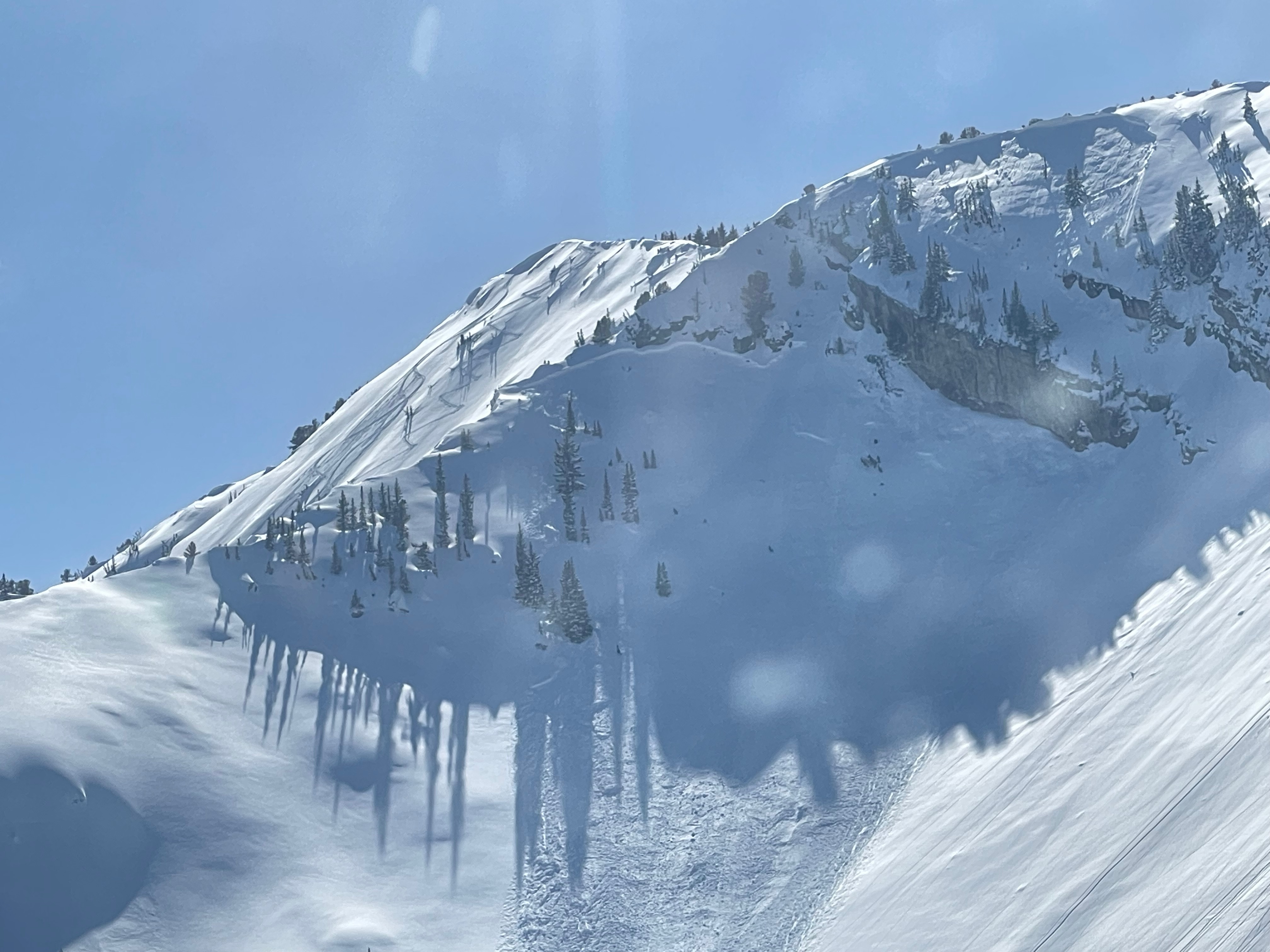
Avalanche danger was CONSIDERABLE at mid and upper elevations, where human-triggered avalanches were likely in storm slabs and wind-drifted snow. Notable activity on this day included human-triggered slides on the Catchers Mitt on Kessler Peak and in the Crystal Palace of Days Fork, along with a hiker caught and carried on Mt. Olympus. Each of the first two avalanches were remotely triggered, with other parties getting dusted by the avalanche on Kessler. These slides were on wind loaded northeast facing slopes in the upper elevations, and failed near the dust layer 2–3 feet deep.
Photo of the Catchers Mitt avalanche on Kessler Peak
Tragically, the community mourns the loss of long time UAC backcountry observer Michael Janulaitis, who was caught and killed in an avalanche near Hoyt Peak in the Uintas.
Saturday, March 8
The snowpack remained reactive, with CONSIDERABLE danger on steep, northwest through northeast-facing terrain.
The snowpack remained reactive, with CONSIDERABLE danger on steep, northwest through northeast-facing terrain.
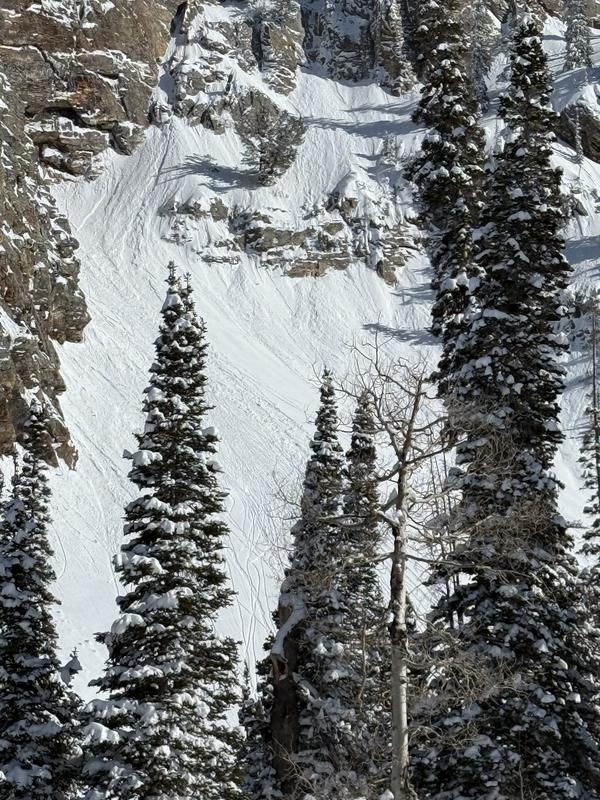
The sun played a major role in stability, rapidly warming south-facing slopes and triggering wet snow instability by midday. As the snow heated up, the danger rose to CONSIDERABLE, making early starts and exits essential. Recent storm snow also began shedding from roofs in mountain neighborhoods.
Shallow wind-drifted slabs broke near ridgelines, and wet loose slides became more widespread throughout the afternoon.
Example of wide-spread wet-loose activity in Mill B South
Sunday, March 9
It was another warm day in the Wasatch, with avalanche conditions shifting quickly under the strong March sun. The avalanche danger remained MODERATE on steep, northwest through northeast-facing terrain, where concerns over the buried persistent weak layers—both near the old dirt-stained surface and deeper in the snowpack—continued to linger. While triggering these layers was less likely, consequences remained severe, with avalanches running 1–4 feet deep.
It was another warm day in the Wasatch, with avalanche conditions shifting quickly under the strong March sun. The avalanche danger remained MODERATE on steep, northwest through northeast-facing terrain, where concerns over the buried persistent weak layers—both near the old dirt-stained surface and deeper in the snowpack—continued to linger. While triggering these layers was less likely, consequences remained severe, with avalanches running 1–4 feet deep.
Wet snow became the primary concern, climbing to CONSIDERABLE danger on sunlit aspects as temperatures spiked 10°F higher than the day before. Wet loose avalanches ran naturally, and human-triggered slides were reported on steep south- and west-facing terrain by early afternoon. With the snowpack failing to refreeze overnight, wet snow instability was expected to occur even earlier the following day.
Monday, March 10
A warm, sunny day brought another day of MODERATE danger and a rising danger for wet snow avalanches on solar aspects and in lower elevation terrain.
A warm, sunny day brought another day of MODERATE danger and a rising danger for wet snow avalanches on solar aspects and in lower elevation terrain.
Persistent weak layers remained a concern, though no new activity was reported. The upper weak layer, buried two feet deep, continued to show instability, while the deeper layer lingered in thin, previously avalanched terrain.
Weather remained consistent with the previous day—clear skies, highs in the upper 40s°F, and increasing southwest winds. A significant storm was on the horizon, expected to bring up to 3 feet of new snow by Friday.
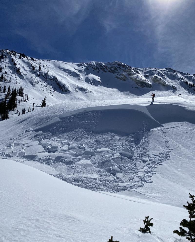
A skier remotely triggered a 3-foot-deep hard wind slab on a heavily wind drifted rollover adjacent to the Red Baldy aprons, failing on near-surface facets. Ski area control teams and other observers noted some fresh natural wind slabs high in the wind zone.
The skier triggered hard slab on a heavily wind loaded rollerover
Tuesday, March 11
A warm, breezy day in the Salt Lake mountains kept MODERATE avalanche danger in place on steep, shaded slopes. Human-triggered avalanches, 1–4 feet deep, remained possible on buried weak layers, particularly where wind-drifted slabs had formed.
A warm, breezy day in the Salt Lake mountains kept MODERATE avalanche danger in place on steep, shaded slopes. Human-triggered avalanches, 1–4 feet deep, remained possible on buried weak layers, particularly where wind-drifted slabs had formed.
The morning refreeze helped, but wet snow instability increased by midday. Southwest winds gusting over 40 mph added fresh drifts to leeward terrain. Meanwhile, a major storm loomed, with 16–28 inches of snow expected by Friday.
Wednesday, March 12
Warm temperatures, strong winds, and buried weak layers kept avalanche conditions active. The danger remained MODERATE, with wind-drifted slabs 1–4 feet deep forming along ridgelines and in terrain features, particularly on north-facing slopes.
Warm temperatures, strong winds, and buried weak layers kept avalanche conditions active. The danger remained MODERATE, with wind-drifted slabs 1–4 feet deep forming along ridgelines and in terrain features, particularly on north-facing slopes.
While wet avalanche concerns diminished, strong southwest winds (gusting 40+ mph) continued to load leeward slopes, maintaining the potential for human-triggered avalanches.
Thursday, March 13
Heavy snowfall and strong winds ramped up avalanche danger. Wind-drifted slabs and new snow avalanches quickly became a concern, with CONSIDERABLE danger at upper elevations, especially on northwest through east-facing slopes. Buried weak layers remained a lingering issue, with additional loading increasing the potential for deeper, more dangerous slides.
Heavy snowfall and strong winds ramped up avalanche danger. Wind-drifted slabs and new snow avalanches quickly became a concern, with CONSIDERABLE danger at upper elevations, especially on northwest through east-facing slopes. Buried weak layers remained a lingering issue, with additional loading increasing the potential for deeper, more dangerous slides.
Winds cranked from the south throughout the day, gusting into the 30s and 40s mph, before shifting northwest with the incoming cold front. Snowfall rates picked up in the afternoon, hitting 2 inches per hour at times. By evening, storm totals ranged from 3 to 14 inches, with more on the way overnight.


