March Kicks Off Our Spring Campaign- Donate Now to Support Forecasting

Forecast for the Skyline Area Mountains

Brett Kobernik
Issued by Brett Kobernik on
Sunday morning, March 9, 2025
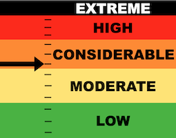
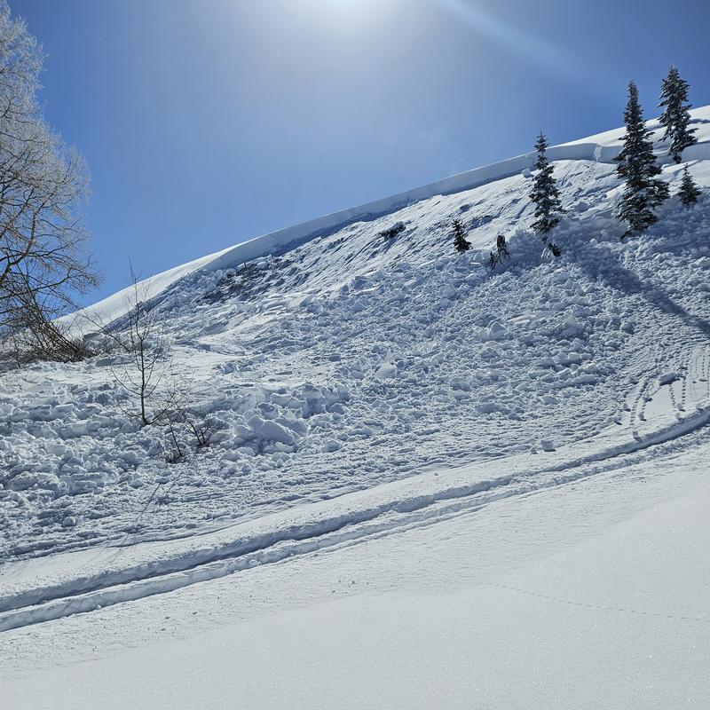
The danger remains CONSIDERABLE on very steep slopes that face northwest through east today.
The big concern is triggering an avalanche that breaks deep into older loose sugary weak layers.
The chances aren't that likely but the consequences are serious. It's a "low probability, high consequence" situation.
Low
Moderate
Considerable
High
Extreme
Learn how to read the forecast here
Special Announcements
I'm sad to report that an avalanche fatality occurred on Friday. A solo person on a snowbike rode out to near Hoyt Peak in the Uinta Mtns. He parked the snowbike and was going to make a few backcountry ski runs. It appears that he climbed to the top of Hoyt Peak and dropped in on a steep northeast facing bowl where he triggered an avalanche and was caught and carried down the slope. He was reported missing late Friday and was found Saturday morning. As always, we find these accidents tragic.
Weather and Snow
Current Conditions: Saturday was another spectacular day of powder riding. Temperatures generally stayed fairly cold but many slopes did get hit by the sun and you'll find frozen crusts this morning. Temperatures on Saturday topped out at 30˚F with a few stations pushing into the mid 30s. The wind has been almost non-existent but overall is from the north. Cold dry powder remains on many upper elevation more northerly facing slopes.
Mountain Weather: Warm temperatures and sun today is going to put an end to our little "powder party" that we've been having this week. We'll see high temperatures up around 40˚F or a bit higher. The wind is going to continue to be calm to light in speed. It'll switch direction and come from the southwest. Monday looks like a duplicate. Another storm is advertised for later in the week which could bring another good shot of snow.
Recent Avalanches
There was one significant avalanche reported from the Skyline on Saturday. It was remotely triggered (triggered from a distance) by a snowmobiler. No one was actually on the slope. It broke into weak sugary faceted snow and basically took out the entire winter snowpack. This is crucial information for us because it tells us that the older weak sugary snow deeper in the snowpack is still unstable in some places. This was in the Cabin Hollow area (tributarty of Gooseberry Creek) on North Skyline. This is an area that I would describe as having a shallower snowpack thus, overall a weaker snowpack. MORE DETAILS HERE
PHOTO: Matt Wilson
Ad
Avalanche Problem #1
Persistent Weak Layer
Type
Location
Likelihood
Size
Description
The avalanche in Cabin Hollow demonstrates exactly what kind of threat we're dealing with. Avalanches that break into older weak sugary faceted snow can still be triggered today. These "Persistent Weak Layers" have really lived up to their name this year as they have persisted since early in the winter. All you can do is avoid steep terrain until we are satisfied that these layers have gained enough strength. We aren't there yet.
On a side note, I was very impressed by the restraint riders had about getting into the big, steep terrain on Saturday. It was a busy day and I noticed that many of the big slopes were left untracked. Good job people. The bottom line is that you can't just hit the big stuff every day you go out. You need to wait for conditions to be stable. It appears a lot of people are understanding this concept. It's been a difficult year for those of us who like to get into steep terrain but having patience is the only way you'll do this for the long run.
Avalanche Problem #2
Wet Snow
Type
Location
Likelihood
Size
Description
Be aware that we may see some wet avalanche activity on sunny slopes today as the warm temperatures make the cold snow become damp. In general, this doesn't usually pose a great threat to people on the Skyline. However, if you get into the wrong place at the wrong time, there is certainly some danger. Simply avoid steep terrain when the snow becomes really wet and sloppy.
General Announcements
This forecast is from the U.S.D.A. Forest Service, which is solely responsible for its content. This forecast describes general avalanche conditions and local variations always occur.