

Nikki Champion
Forecaster
Week in Review: Avalanche Conditions and Snowpack Developments (February 7 - February 13, 2025)
Each week, we look back at the key snowfall, weather, and avalanche events from the previous week. For archived forecasts, visit the Salt Lake Mountains’ past updates.
Overall Summary:
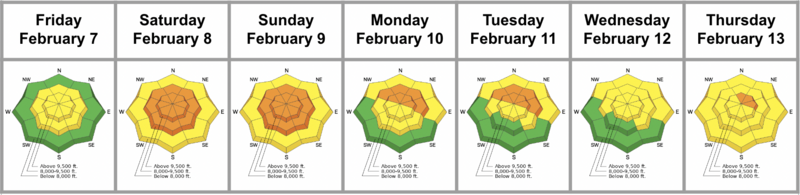
A potent storm Friday delivered 6–19 inches of heavy snow, rapidly loading an already unstable snowpack triggering a widespread avalanche cycle and bumping danger to CONSIDERABLE for much of the week. Saturday saw numerous large and dangerous slides, including a fatal avalanche in East Bowl of Silver Fork, a full burial at Dutch Draw, and several slides in Days Fork and Bear Trap. Many of these avalanches, breaking 1–4 feet deep, failed within the storm snow or stepped down into old faceted layers. As skies cleared, backcountry travel increased, leading to several close calls, including a skier-triggered slide in Mineral Fork that stepped to the ground and two skier-involved avalanches on Cardiac Ridge and Lake Peak.
A potent storm Friday delivered 6–19 inches of heavy snow, rapidly loading an already unstable snowpack triggering a widespread avalanche cycle and bumping danger to CONSIDERABLE for much of the week. Saturday saw numerous large and dangerous slides, including a fatal avalanche in East Bowl of Silver Fork, a full burial at Dutch Draw, and several slides in Days Fork and Bear Trap. Many of these avalanches, breaking 1–4 feet deep, failed within the storm snow or stepped down into old faceted layers. As skies cleared, backcountry travel increased, leading to several close calls, including a skier-triggered slide in Mineral Fork that stepped to the ground and two skier-involved avalanches on Cardiac Ridge and Lake Peak.
Midweek brought an extreme cold snap, with wind chills near -50°F, keeping travel minimal. Avalanche danger dropped to MODERATE, but with a major storm on the horizon, an Avalanche Watch has been issued. Avalanche danger is expected to rise rapidly into the weekend.
Friday, February 7
A sneaker storm pushed into the Wasatch, bringing strong winds and plenty of graupel (round pellet snow). Around 2:00 PM, a cold front moved through, winds diminished, and temperatures dropped. Storm totals over 24 hours ranged from 6 to 19 inches of snow, containing 0.65 to 2.84 inches of water. Upper Little and Big Cottonwood Canyons received the lion’s share, followed by PC Ridge with 9 inches of snow and 1.50 inches of water. Lower elevations picked up around 6 inches.
A sneaker storm pushed into the Wasatch, bringing strong winds and plenty of graupel (round pellet snow). Around 2:00 PM, a cold front moved through, winds diminished, and temperatures dropped. Storm totals over 24 hours ranged from 6 to 19 inches of snow, containing 0.65 to 2.84 inches of water. Upper Little and Big Cottonwood Canyons received the lion’s share, followed by PC Ridge with 9 inches of snow and 1.50 inches of water. Lower elevations picked up around 6 inches.
Backcountry observers noted dry loose avalanches consisting of graupel during periods of high precipitation intensity. One avalanche was reported from the Mary Chutes in upper Big Cottonwood—a graupel pool that failed at the new/old snow interface. Avalanche danger was MODERATE, with the potential to rise to CONSIDERABLE by the end of the day.
Saturday, February 8
With impressive snowfall totals, avalanche danger rose to CONSIDERABLE on all aspects at mid and upper elevations. The sun came out, and many deep and dangerous avalanches were triggered, including a tragic fatality involving a local community member. These avalanches failed within the new snow or broke deeper into older, faceted layers. Crown depths ranged from 1 to 4 feet, with widths up to 200 feet. Many were large enough to catch, carry, and fully bury someone:
With impressive snowfall totals, avalanche danger rose to CONSIDERABLE on all aspects at mid and upper elevations. The sun came out, and many deep and dangerous avalanches were triggered, including a tragic fatality involving a local community member. These avalanches failed within the new snow or broke deeper into older, faceted layers. Crown depths ranged from 1 to 4 feet, with widths up to 200 feet. Many were large enough to catch, carry, and fully bury someone:
Sunday, February 9
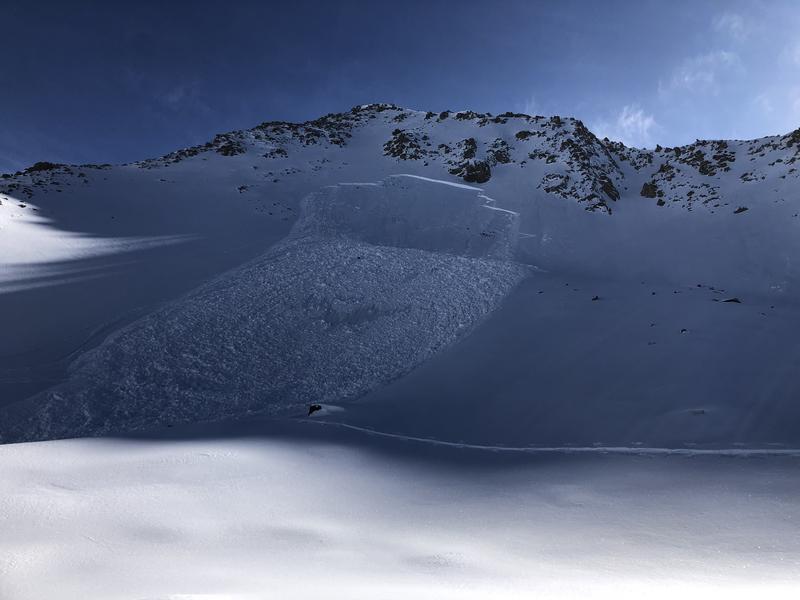
With another day of sunny skies, avalanche danger remained CONSIDERABLE at all aspects at mid and upper elevations. Trent warned: "With bluebird skies and plenty of powder, I can't help but think we will see another accident today. DO NOT let powder fever cloud your judgment." Observers noted a widespread cycle of large natural avalanches from the Room of Doom in upper Mineral Fork to a broad swath of activity in Broads Fork, the Raymond Slabs of upper Porter Fork, Wilson Chutes, and upper Snake Creek. In lower Mineral Fork, a skier remotely triggered a soft slab avalanche that stepped down to the ground. This was a repeater slope that had avalanched over the holidays—a steep, northeast-facing slope at 9,000 feet. The slide broke 2.5 feet deep and 100 feet wide. Along the PC ridgeline, ski patrol triggered an avalanche with a ski cut that collapsed a crust a foot deep and 40 feet wide on an east-facing slope at 8,700 feet.
With another day of sunny skies, avalanche danger remained CONSIDERABLE at all aspects at mid and upper elevations. Trent warned: "With bluebird skies and plenty of powder, I can't help but think we will see another accident today. DO NOT let powder fever cloud your judgment." Observers noted a widespread cycle of large natural avalanches from the Room of Doom in upper Mineral Fork to a broad swath of activity in Broads Fork, the Raymond Slabs of upper Porter Fork, Wilson Chutes, and upper Snake Creek. In lower Mineral Fork, a skier remotely triggered a soft slab avalanche that stepped down to the ground. This was a repeater slope that had avalanched over the holidays—a steep, northeast-facing slope at 9,000 feet. The slide broke 2.5 feet deep and 100 feet wide. Along the PC ridgeline, ski patrol triggered an avalanche with a ski cut that collapsed a crust a foot deep and 40 feet wide on an east-facing slope at 8,700 feet.
Monday, February 10
Skies cleared, and temperatures rose. Avalanche danger remained CONSIDERABLE on many mid and upper elevation slopes, with the most pronounced risk on northwest to east-facing terrain.
Skies cleared, and temperatures rose. Avalanche danger remained CONSIDERABLE on many mid and upper elevation slopes, with the most pronounced risk on northwest to east-facing terrain.
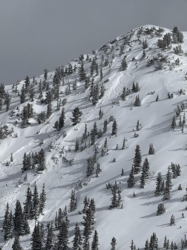
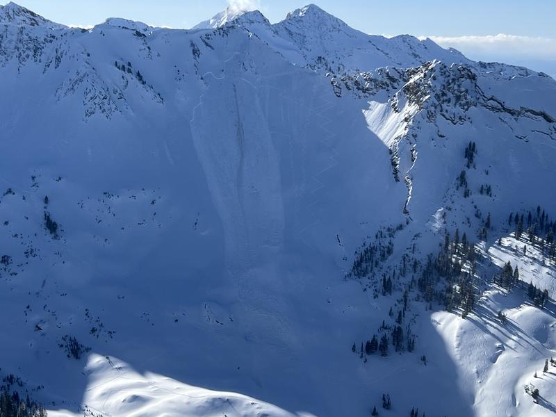
Two avalanches were unintentionally triggered by highly experienced backcountry skiers—both close calls:
- Cardiac Ridge (10,400', NE-facing): A skier triggered an avalanche breaking 2–3 feet deep and over 200 feet wide, leaving a large debris pile. The skier skied off the slab at the top and was not caught.
- Lake Peak, White Pine (10,400', N-facing): A solo skier remotely triggered an avalanche from the uptrack. The slide broke 2.5 feet deep and 300 feet wide, releasing 300 feet above him. He was caught, carried 500 feet, but was able to dust himself off and ski away. Five previous tracks were on the slope.
Both avalanches failed on old faceted snow in terrain that had previously slid during the Christmas cycle. Ski area control teams also triggered hard slabs of wind-drifted snow in the high alpine of Little Cottonwood Canyon.
Cardiac Ridge - 10,400' - NE Aspect
Lake Peak -10,400' - N Facing
Tuesday, February 11
Temperatures dropped significantly, but CONSIDERABLE danger remained on mid and upper elevations northwest to east-facing slopes. No new avalanches were reported in the backcountry, though ski resorts noted sensitive wind slabs forming at mid and upper elevations.
Temperatures dropped significantly, but CONSIDERABLE danger remained on mid and upper elevations northwest to east-facing slopes. No new avalanches were reported in the backcountry, though ski resorts noted sensitive wind slabs forming at mid and upper elevations.
Wednesday, February 12
A bitterly cold day, with morning temperatures well below zero and wind chills nearing -50°F along the highest ridgelines. The sun came out, but the extreme cold seemed to keep most travelers at bay. No new avalanches were reported in the backcountry, though ski patrol teams observed shallow soft and hard slabs of wind-drifted snow in typical leeward terrain. Avalanche danger dropped to MODERATE at all elevations.
A bitterly cold day, with morning temperatures well below zero and wind chills nearing -50°F along the highest ridgelines. The sun came out, but the extreme cold seemed to keep most travelers at bay. No new avalanches were reported in the backcountry, though ski patrol teams observed shallow soft and hard slabs of wind-drifted snow in typical leeward terrain. Avalanche danger dropped to MODERATE at all elevations.
The main story: an incoming storm.
Thursday, February 13
An Avalanche Watch was issued for most of the state. Avalanche danger remained MODERATE on many steep slopes due to existing and developing soft and hard slabs of wind-drifted snow. With the incoming storm, the danger was expected to reach CONSIDERABLE by the afternoon and HIGH overnight. Avalanche danger will rapidly increase into the weekend with one of the most significant winter storms of the season.
An Avalanche Watch was issued for most of the state. Avalanche danger remained MODERATE on many steep slopes due to existing and developing soft and hard slabs of wind-drifted snow. With the incoming storm, the danger was expected to reach CONSIDERABLE by the afternoon and HIGH overnight. Avalanche danger will rapidly increase into the weekend with one of the most significant winter storms of the season.


