Nikki Champion
Forecaster
Week in Review: Avalanche Conditions and Snowpack Developments (January 24 - January 30th, 2025)
Each week, we look back at the key snowfall, weather, and avalanche events from the previous week. For archived forecasts, visit the Salt Lake Mountains’ past updates.
Overall Summary:
A week of shifting conditions in the Wasatch brought moderate avalanche danger, with wind-drifted snow and persistent weak layer concerns dominating the forecast. Early in the period, strong winds and light snowfall contributed to isolated instability, with a small skier-triggered slide on Tuscarora. By Sunday, several larger avalanches occurred across the range, including skier- and naturally triggered hard slabs up to 2 feet deep on wind-loaded slopes.
A week of shifting conditions in the Wasatch brought moderate avalanche danger, with wind-drifted snow and persistent weak layer concerns dominating the forecast. Early in the period, strong winds and light snowfall contributed to isolated instability, with a small skier-triggered slide on Tuscarora. By Sunday, several larger avalanches occurred across the range, including skier- and naturally triggered hard slabs up to 2 feet deep on wind-loaded slopes.
As the week progressed, clear skies and fluctuating temperatures increased variability in snow conditions. East winds midweek caused additional wind loading but did not create widespread instability. By Thursday, avalanche danger dropped to LOW at all elevations, though riding conditions remained variable with a mix of sun crusts, faceted snow, and lingering wind slabs.
Friday, January 24
A quiet, overcast prefrontal day with increasing winds gusting up to 50 mph along ridgelines. Avalanche danger remained MODERATE at upper elevations and on northwest through east-facing aspects due to wind-drifted snow and lingering persistent weak layer (PWL) concerns.
A quiet, overcast prefrontal day with increasing winds gusting up to 50 mph along ridgelines. Avalanche danger remained MODERATE at upper elevations and on northwest through east-facing aspects due to wind-drifted snow and lingering persistent weak layer (PWL) concerns.
Saturday, January 25
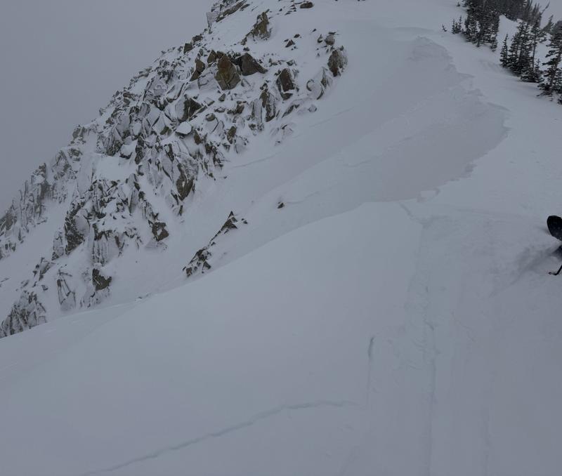
Overnight snowfall totaled 1–3 inches, with light accumulation throughout the day bringing storm totals to 1–5.5 inches. Danger remained MODERATE. A skier remotely triggered a 3-inch-deep, 50-foot-wide soft slab avalanche on a north-facing, 38° slope at 10,600' on Tuscarora likely failing at the new snow/old snow interface. Observers noted its surprising propagation, suggesting faceted snow may have played a role.
Overnight snowfall totaled 1–3 inches, with light accumulation throughout the day bringing storm totals to 1–5.5 inches. Danger remained MODERATE. A skier remotely triggered a 3-inch-deep, 50-foot-wide soft slab avalanche on a north-facing, 38° slope at 10,600' on Tuscarora likely failing at the new snow/old snow interface. Observers noted its surprising propagation, suggesting faceted snow may have played a role.
Tuscarora Avalanche - Will & Jackson
Sunday, January 26
Winds eased, and avalanche danger remained MODERATE. The sun made a rare appearance, and several avalanches, ranging from 1 to 2 feet deep, occurred across the Salt Lake area mountains. Loose-dry avalanches were reported Saturday, with a few wet-loose slides occurring late Sunday afternoon.
Winds eased, and avalanche danger remained MODERATE. The sun made a rare appearance, and several avalanches, ranging from 1 to 2 feet deep, occurred across the Salt Lake area mountains. Loose-dry avalanches were reported Saturday, with a few wet-loose slides occurring late Sunday afternoon.
A few of the notable avalanches reported:
- Little Superior Bowl (Cardiff Fork): Skier-triggered, 2-foot-deep hard slab on a northeast-facing slope at 10,100', running 500 feet. Strong southern winds had loaded snow onto a weak layer.
- Little Water Peak (Mill D North): Skier-triggered, 1 to 2-foot-deep hard slab on a north aspect at 9,400'. The slide was 100 feet wide; the skier escaped uninjured.
- Birthday Chutes (White Pine): Likely a natural hard slab avalanche on a northwest aspect at 10,600'. The crown was approximately 1 foot deep and 125 feet wide.
- Mongo No (Mineral Fork): Natural soft slab avalanche on a north aspect at 9,900', running 800–1,000 feet. Likely occurred late Saturday or early Sunday. The exact dimensions are unknown.
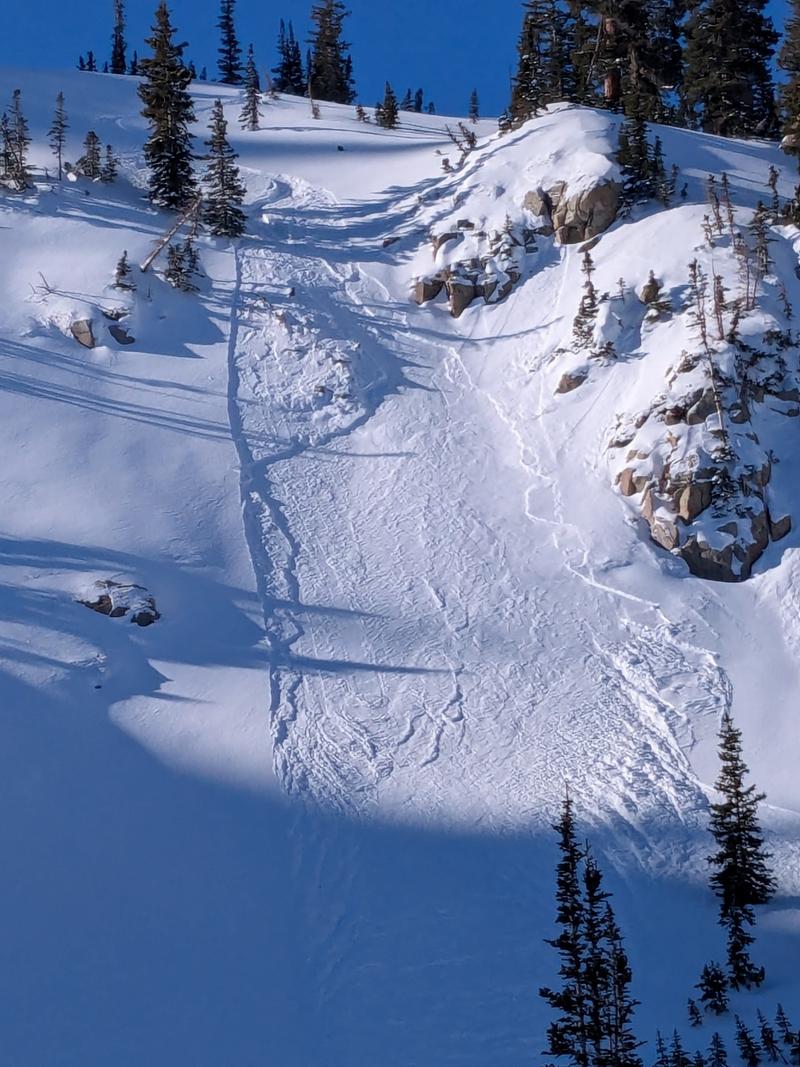
- 1,000 Turns Gully (Brighton Perimeter): A snowboarder-triggered soft slab avalanche on a northeast aspect at 9,800', likely caused by wind-drifted snow over a density change. The crown was approximately 6 inches deep and 30 feet wide.
1000 Turns Gully avalanche
- Tibble Fork (Forest Lake Drainage, outside the Central Wasatch): Skier-triggered, 3.5-foot-deep hard slab on an east aspect at 9,400', 150 feet wide, running 200 feet. It likely failed on facets near the ground.
Drew at the Forest Lake avalanche
Monday, January 27
Skies remained clear, but temperatures hovered near freezing. Avalanche danger held at MODERATE due to wind-drifted snow and lingering PWL issues. No new avalanches were reported; all observed activity occurred the previous day.
Skies remained clear, but temperatures hovered near freezing. Avalanche danger held at MODERATE due to wind-drifted snow and lingering PWL issues. No new avalanches were reported; all observed activity occurred the previous day.
Tuesday, January 28
Another sunny day, accompanied by east winds—never a welcome direction. While they didn't cause major instability, the snow surface showed clear signs of weakening. Avalanche danger remained MODERATE at upper elevations. Ski patrol teams reported active wind loading, triggering numerous soft slabs in the high alpine. Backcountry skiers intentionally released shallow wind slabs (4–8 inches deep) cross-loaded onto terrain features and loose facet sluffs in steep, northerly terrain.
Another sunny day, accompanied by east winds—never a welcome direction. While they didn't cause major instability, the snow surface showed clear signs of weakening. Avalanche danger remained MODERATE at upper elevations. Ski patrol teams reported active wind loading, triggering numerous soft slabs in the high alpine. Backcountry skiers intentionally released shallow wind slabs (4–8 inches deep) cross-loaded onto terrain features and loose facet sluffs in steep, northerly terrain.
Wednesday, January 29
Yet another sunny day across the Wasatch. Moderate winds continued, visibly transporting snow along ridgelines. MODERATE danger persisted at upper elevations. Ski and ride conditions became more variable, with sun crust forming on solar aspects and wind slabs faceting out on polar aspects.
Yet another sunny day across the Wasatch. Moderate winds continued, visibly transporting snow along ridgelines. MODERATE danger persisted at upper elevations. Ski and ride conditions became more variable, with sun crust forming on solar aspects and wind slabs faceting out on polar aspects.
Thursday, January 30
Before the next storm moves in, avalanche danger dropped to LOW at all aspects and elevations. A final day of sunny skies and warm temperatures. Riding conditions remain variable. Avalanche danger expected to rise going into the weekend, with warm weather and high water totals possible.
Before the next storm moves in, avalanche danger dropped to LOW at all aspects and elevations. A final day of sunny skies and warm temperatures. Riding conditions remain variable. Avalanche danger expected to rise going into the weekend, with warm weather and high water totals possible.