Join us at our 2nd Annual Blizzard Ball

Forecast for the Moab Area Mountains

Eric Trenbeath
Issued by Eric Trenbeath on
Monday morning, January 6, 2025
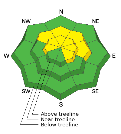
The avalanche danger remains MODERATE on steep, northwest through easterly aspects near treeline and above where recent and wind drifted snow have increased the likelihood for human triggered avalanches 1-3 feet deep failing on a buried persistent weak layer. This danger may also exist on W and SE aspects above treeline.

Most other terrain has LOW danger. Small avalanches on isolated terrain features are possible.

It's still low tide out there and rocks, stumps, and logs are lurking just beneath the surface.
Low
Moderate
Considerable
High
Extreme
Learn how to read the forecast here
Special Announcements
Geyser Pass Road: The road has not been plowed since the last storm but many vehicles yesterday packed in the recent snow. Surface is mainly snowpacked and icy. AWD with good tires required.
Grooming Conditions: The Geyser Pass road was groomed yesterday afternoon.
Weather and Snow
6 A.M. Snow and Weather Data
24 Hour Snow: 0" 72 Hour Snow: 5" Season Total Snow: 57" Depth at Gold Basin: 29"
Winds on Pre-Laurel Peak: NW 5-10 Temp: 12° F Percent of Normal (SWE): 106%
Weather
Expect cold and cloudy conditions with a slight chance for snow developing later today as a broad low pressure system moves over the inter-mountain West. NW winds will remain light and high temps will be in the low 20's. A chance for snow increases slightly on Tuesday as a strong low pressure system develops far to the south. Skies clear on Wednesday.
General Conditions
With about a foot of accumulated snow since Christmas, it's finally game on in the La Sals. Conditions still remain a bit thin however. Near treeline and above, winds have affected the snow surface on all aspects although you can find a few diamonds in the rough. Below treeline, soft snow can be found on all aspects with about 4-6 inches of low density powder. Our primary concern is a layer of faceted snow that developed at the surface during the December high pressure. Basal facets remain a concern in some areas as well.
Snowpack and Weather Data
Gold Basin SNOTEL site (10,000')
SNOTEL site near Geyser Pass Winter Trailhead (9600')
Wind Station on Pre-Laurel Peak (11,400')
NWS forecast for the La Sal Mountains.
Recent Avalanches
Ad
Avalanche Problem #1
Persistent Weak Layer
Type
Location
Likelihood
Size
Description
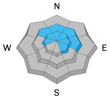
Recent and wind drifted snow have added additional stress to buried persistent weak layers increasing the likelihood for human triggered avalanches in some locations. The danger is greatest on steep, windloaded, northerly aspects near treeline and above.
We have two primary persistent weak layers of faceted snow. The first layer is the old snow surface that faceted and weakened during the long high pressure spell. It is now covered by the last two storm events. Human triggered avalanches are most likely to fail here first and they could be 1-2 feet deep in drifted areas. It's important to carefully analyze any slope you are considering by digging down to see if this structure exists. Avalanches triggered on this weak layer could also step down into our second faceted weak layer at the base of the snowpack. Avalanches failing on this layer would be deep, dangerous, and possibly unsurvivable.
Full depth avalanches failing on basal facets may also be triggered from thin, rocky areas or along slope margins. This a less likely scenario but one that can't be discounted. Minimize your risk by avoiding thin rocky areas, steep convexities, and radical terrain.
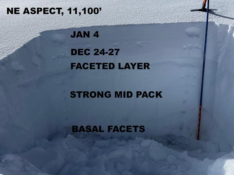
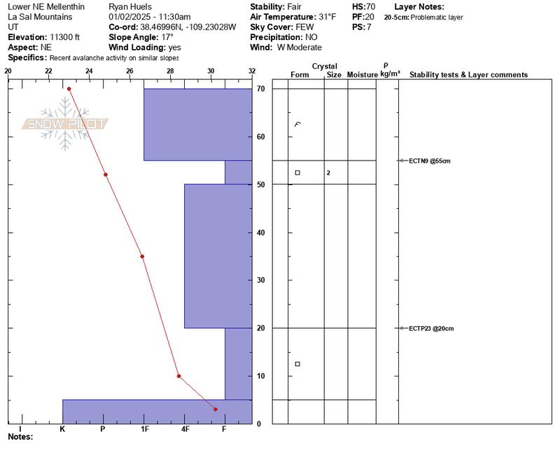
I dug this pit on a NE aspect near treeline at 11,100'. An extended columnn test produced easy propagation (ECTP 6) on the buried near surface facted layer. Notice how the structure of this pit mimics the one below from Ryan Huels at a similar aspect and elevation.
This snowpit from Ryan Huels perfectly illustrates the snow structure we are most concerned with. Note the obvious dense slab on top over weak faceted snow. The diagram also illustrates the weak faceted layer at the base of the snowpack.
Additional Information
The final accident reports for Porter Fork and Davenport Hill up in the Wasatch Mountains have been completed. Our hearts go out to all who were affected by these tragic events.
Sign up for text alerts to get the most up to date information about changing conditions, road plowing, special avalanche announcements.
Follow us on Instagram @utavy_moab
General Announcements
This forecast is from the U.S.D.A. Forest Service, which is solely responsible for its content. This forecast describes general avalanche conditions and local variations always occur.