Observation Date
12/28/2024
Observer Name
John Lemnotis
Region
Salt Lake » Big Cottonwood Canyon » Brighton Hill
Location Name or Route
Brighton Hill
Weather
Sky
Obscured
Precipitation
Moderate Snowfall
Wind Direction
Southwest
Wind Speed
Moderate
Weather Comments
Arrived at Guardsmans around 8:30a with moderate snow and freezing temps. Snow was sporadic throughout the day with short periods of light to moderate snowfall. There was a general warming trend throughout the day by our exit at 2pm. Winds stayed consistent from W and SW with moderate speeds and strong gusts between 9K-10k' where we traveled. Visible snow transport was frequent and obvious with E aspects taking the brunt of the loading.
Snow Characteristics
New Snow Depth
12"
New Snow Density
Medium
Snow Surface Conditions
Powder
Dense Loose
Snow Characteristics Comments
The new snow in exposed lee areas was medium in density due to the warm temps of the storm and the amount of snow that has been transported with the strong winds. The surface was very supportable even off of the skin track. In protected areas the new snow still felt a bit heavy by Wasatch standards with ski pen on the downhill not going above the boot top in low angle terrain.
Red Flags
Red Flags
Recent Avalanches
Heavy Snowfall
Wind Loading
Cracking
Collapsing
Poor Snowpack Structure
Red Flags Comments
Most of the red flags are present right now. The storm cycle has laid down a significant load in terms of water weight being well over the previous load that helped lead to the avalanches from 12/15-12/17. Additional weight is being added with the strong and relentless winds associated with this storm. Today cracking and collapsing was the name of the game when you got off the skin track or were breaking trail, especially in areas where wind has increased the load on a slope that contains the PWL. PWL is still present and reactive in snow pit tests.
Avalanche Problem #1
Problem
Persistent Weak Layer
Problem #1 Comments
This is still the primary concern throughout the range. There is now a cohesive slab on top of the PWL and it is producing many very large avalanches. Right now, bulls eye data is cracking, collapsing, and other avalanches occuring on this layer.
Avalanche Problem #2
Problem
Wind Drifted Snow
Problem #2 Comments
With strong winds throughout the storm so far we have seen reactive fresh wind slabs. These will subside relatively soon after the wind dies down but many old wind slabs will still sit above the PWL leaving it to react like a hard slab. This could lead to a false sense of security in areas that get skied without incident in the coming days.
Comments
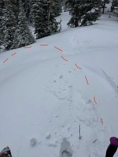
Photo below highlights a shooting crack when stepping a foot off of the skin track to 10420 from the Guardsmans lot. The slope visibly settled, this is a NE aspect at about 9300'. Other whumphs and collapses were noted in similar terrain.
Today's Observed Danger Rating
None
Tomorrows Estimated Danger Rating
None
Coordinates


