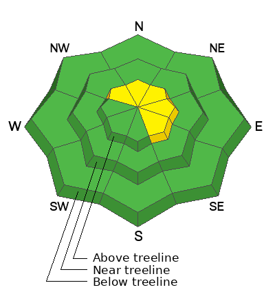
Geyser Pass Road: The road was previously plowed to the trailhead. Expect light accumulations on the road today. AWD with good tires is recommended.
Grooming Conditions: Surfaces are currently packed solid from weeks of ski and snowmobile traffic. We really need some fresh snow to start grooming.
Now is a great time to dial in your safety gear including putting fresh new batteries in your beacons! Local shops across the state will be handing out free Batteries for Beacons now until February 1, 2025. All you need to do is fill out a quick survey and grab the AAA or AA batteries you need to keep your beacon fresh this season. Head into
Moab Gear Trader to get yours!
6 A.M. Snow and Weather Data
24 Hour Snow: 2" 72 Hour Snow: 2" Season Total Snow: 48" Depth at Gold Basin: 25"
Winds on Pre-Laurel Peak: SE 31 G38 Temp: 28° F Percent of Normal (SWE): 105%
Weather
It's looking like a white Christmas in the La Sal Mountains. This morning, snow is falling, and it is 28 degrees F. Temperatures will remain steady. Snowfall will continue until the early afternoon and we can expect total accumulations of 3-5 inches. Overnight, winds blew steadily in the 20s MPH out of the S and are currently howling in the 30s out of the SE. Wind speeds will slowly back off today and blow out of the West at 5-10 MPH. Winds will shift to the NW tonight, and a brief pause is expected with clear skies into Thursday morning. Another disturbance arrives Thursday afternoon and could bring an additional 1-3 inches of snow. Light snow showers will linger Friday into Saturday with modest accumulation. The pattern remains active into the New Year.
General Conditions
We may only see 3-5 inches of snow today, but the first snowfall in about four weeks is big news. Backcountry travelers need to be alert to changing conditions, as we have finally broken the long dry spell and avalanche danger is on the rise. Widespread weak and faceted snow is the result of the extended period of mild weather. This week, new snow is falling on very weak snow that exists near treeline and below. Initially, there won't be an avalanche problem, but as we slowly stack up more snow this week and into the weekend, we may see slab avalanches failing on the weak pre-existing snow. It all depends on how much snow falls and if and when we build a slab on top. For today, your main concern will be areas of drifted snow above the treeline. Strong Southerly winds are drifting today's storm snow onto leeward slopes. Be aware of newly formed drifts that will be sensitive to the weight of skiers and riders. Stay alert to potentially rising avalanche danger as storm snow slowly stacks up in the coming days.
Snowpack and Weather Data


