Join us at our 2nd Annual Blizzard Ball

Forecast for the Moab Area Mountains

Eric Trenbeath
Issued by Eric Trenbeath on
Thursday morning, December 26, 2024
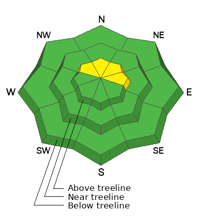
An isolated or MODERATE danger exists for human triggered avalanches involving shallow slabs of wind drifted snow on steep slopes above treeline that face NW-N-NE-E. The biggest threat from these shallow slabs will be getting swept off your feet and possibly carried into rocks or over a cliff in areas of extreme terrain.
All other slopes have a LOW danger. Be aware of increasing avalanche danger into the weekend as incremental loading stacks up on widespread weak snow surfaces.
It's still low tide out there, and a small amount of new snow will just barely cover rocks, stumps, and logs beneath the surface.
Low
Moderate
Considerable
High
Extreme
Learn how to read the forecast here
Special Announcements
Geyser Pass Road: The road is plowed to the trailhead. Surface is dirt down low, with hard slick patches of snow above. AWD with good tires is recommended.
Grooming Conditions: Surfaces that were packed solid from weeks of ski and snowmobile traffic now have a couple of inches on them.
Now is a great time to dial in your safety gear including putting fresh new batteries in your beacons! Local shops across the state will be handing out free Batteries for Beacons now until February 1, 2025. All you need to do is fill out a quick survey and grab the AAA or AA batteries you need to keep your beacon fresh this season. Head into Moab Gear Trader to get yours!
Weather and Snow
6 A.M. Snow and Weather Data
24 Hour Snow: 0" 72 Hour Snow: 2" Season Total Snow: 48" Depth at Gold Basin: 25"
Winds on Pre-Laurel Peak: WSW 5-10 Temp: 17° F Percent of Normal (SWE): 105%
Weather
A transitory ridge over the area will move easterly this morning as a short wave trough nudges through the northern Great Basin. Look for developing clouds today and a slight chance for snow by afternoon. High temps will be in the mid 20's at 10,000' and winds will be mostly light from the WSW. We'll see another chance for snow on Friday, and again on Sunday. Although the West is finally seeing a shift into a more progressive pattern, most of the action will take place north of us.
General Conditions
I'm afraid the Christmas storm failed to deliver beyond the 2" that fell overnight on Christmas Eve. I've often been impressed with what a couple of inches can do to refresh conditions but with the way things are, we're going to need more than that. Hopefully we'll stack up a few more by Sunday. As it is, the recent snow will barely fill in the gaps in the high country where rocks, crusts, and hard surfaces abound. Sheltered, northerly facing terrain below treeline is where you will find the most benefit from the recent snow. In these areas the snowpack has generally lost cohesion but at least it's soft. The problem is that it's still quite shallow, and no longer very supportive.
Snowpack and Weather Data
Gold Basin SNOTEL site (10,000')
SNOTEL site near Geyser Pass Winter Trailhead (9600')
Wind Station on Pre-Laurel Peak (11,400')
NWS forecast for the La Sal Mountains.
Recent Avalanches
Ad
Avalanche Problem #1
Wind Drifted Snow
Type
Location
Likelihood
Size
Description
A few inches of snow and strong southerly winds on Christmas Eve created isolated slabs of wind drifted snow in the high country. Generally speaking, these should be fairly benign and not deep enough to bury you. With all of the underlying slick surfaces about they could however, sweep you off your feet and carry you into rocks or over a cliff. Look for recent deposits of wind drifted snow on the leeward sides of ridge crests and terrain features in upper elevation, wind affected terrain.
Avalanche Problem #2
Persistent Weak Layer
Type
Location
Likelihood
Size
Description
Persistent weak layers in the snowpack are generally benign at this time but looking ahead, it's important that we keep the existing poor snowpack structure in mind. Generally speaking, the snowpack near treeline and below is faceted through to the ground at this point. There are areas where the midpack still has some semblance of a denser slab, but with very weak snow above and below, it's turned into an unstable base for future snowloads. Above treeline things are a little more complex. Much of the snow pack is again weak and faceted, but hard wind slabs over riding the weak snow add to the mix. The best case scenario would be for a big dump to cause a widepsread avalanche cycle that would clean everything out. A more likely scenario will be a tenuous, incremental loading on top of the unstable base. The bottome line, is that when we start adding snow, steep, north facing slopes will be a no go.
Additional Information
Sign up for text alerts to get the most up to date information about changing conditions, road plowing, special avalanche announcements.
Follow us on Instagram @utavy_moab
General Announcements
This forecast is from the U.S.D.A. Forest Service, which is solely responsible for its content. This forecast describes general avalanche conditions and local variations always occur.