UDOT PLANNED AVALANCHE CLOSURES!!

Forecast for the Provo Area Mountains

Nikki Champion
Issued by Nikki Champion on
Thursday morning, March 28, 2024
Throughout the day, the incoming storm may cause avalanche danger to rise to MODERATE on all mid and upper-elevation slopes, where periods of heavy snowfall and strong winds will make human triggered avalanches possible. The elevated winds will continue to form unstable slabs of wind-drifted snow at upper elevations. Both loose snow and slab avalanches may be possible within the different layers of new snow from the past week.

During periods of higher snowfall rates (greater than 1" per hour), avalanches will be easier to trigger. If the snowfall rates spike, the avalanche danger will spike as well. Watch for any signs of instability such as cracking and sluffing.
Low
Moderate
Considerable
High
Extreme
Learn how to read the forecast here
Special Announcements
Support the UAC website backend platform to ensure the ongoing security of the website and the data stored on the site rebuild by donating to our spring campaign.
Weather and Snow
This morning, a winter weather advisory is in effect for the forecast region. Skies are overcast, and light snow has begun in the mountains. Trailhead temperatures are in the low 40s °F, while the highest peaks are in the mid-20s °F. Winds have remained generally elevated since yesterday, blowing from the west, gusting to the 30s mph at mid-elevation ridgelines, and reaching gusts of high 50s mph at the highest ridgelines.
This storm has quietly added a significant amount of water to some locations, bringing up to 2' of settled snow to parts of Provo.
Today, snow showers will develop over northern Utah's mountains in the morning ahead of an approaching cold front, which is expected to cross the region during the afternoon, bringing a period of intense snow and rapid accumulations, particularly in the mid to late afternoon, before weakening into the early evening. Temperatures will range in the upper 30s and low 40s °F with a trace amount to 3.5" of new snow accumulation expected before 5 PM. The west-southwsterly winds will begin to increase, with gusts up to 35-40 MPH at the mid-elevation ridgelines and up to 50-55 MPH at the highest ridgelines. Expect 3-8" of new snow by 6 AM tomorrow morning.
Looking ahead, the boundary will move back north as a warm front on Friday afternoon and evening, bringing more snow. Then, the Pacific trough will affect the area, bringing the most snow on Sunday into early Monday.

Read the updated forecast discussion from our partners at the National Weather Service HERE.
Recent Avalanches
For the Provo area, one small point release was spotted in the Snake Creek zone. An avalanche, estimated at around 400 vertical feet, likely occurred due to natural heat or potential triggering by five snowmobilers. Observed around 12:45 pm, possibly a wet loose type, with intermittent sun exposure. Roller balls were noted on north-facing slopes.
Yesterday was another eventful day in the Central Cottonwoods, marked by various avalanches occurring across locations such as Thunder Ridge, Mt. Raymond, multiple avalanches within Wolverine Cirque, Wilson Chutes, Monte Cristo, and an impressive avalanche of note on Superior. See the photos below.
These avalanches were primarily soft slab avalanches of new snow or wind-drifted snow failing within a density change or at the new snow-old snow interface. Depths ranged from 2 inches to 20 inches, and widths varied between 20 feet and 350 feet.
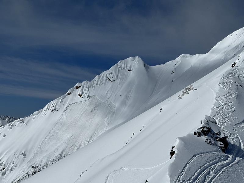
Superior avalanche - Before 10 am, a member of the group remotely triggered an avalanche on Mt. Superior, which ran the entire length of the mountain. Fortunately, despite many people on the mountain, no one was caught. (Hopkins)
The cooler temperatures and elevated wind kept most of the wet snow at bay, but by late afternoon, there were some reports of small wet-loose avalanches running off rocks and across skin tracks on the solar aspects.

Read all the observations HERE.
Ad
Avalanche Problem #1
Wind Drifted Snow
Type
Location
Likelihood
Size
Description
The recent bump in winds plus soft snow available for transport will continue to form soft slabs of wind-drifted snow up to 2' deep. With the winds slated to remain elevated throughout the day, these slabs will only continue to grow, and become more cohesive. These slabs will be most pronounced on lee-ward-facing slopes, but such high winds can load any aspect because winds swirl and change direction as they pass through the mountains.
With new snow throughout the day slopes with any signs of wind-drifted snow, such as texture and pillow-shaped features, may become more challenging to identify. For that reason, I would approach steep terrain feature that could allow for drifting snow to accumulate as if triggering a fresh soft slab is possible.
CORNICES are not to be underestimated. We have received multiple reports of cornice-triggered avalanches in the last two days. Limit your exposure to ridgelines near cornices and slopes below them. A cornice fall could trigger a larger slab of wind-drifted snow below or entrain a significant amount of snow onto the slope below.
Avalanche Problem #2
New Snow
Type
Location
Likelihood
Size
Description
Over the last few days, the new snow has been reactive to backcountry travelers. The primary layers of weakness, in most cases, have been at different density changes within the newest snow or a bit deeper at the new snow/old snow interface.
As the snowfall totals increase today, the avalanche danger is going to increase as well. This incoming front is predicted to have multiple periods of high snowfall rates, up to 1 inch an hour. Out of the wind zone, you can expect to find sensitive soft slabs of new snow and fast, long-running sluffs on all aspects.
General Announcements
This information does not apply to developed ski areas or highways where avalanche control is normally done. This forecast is from the U.S.D.A. Forest Service, which is solely responsible for its content. This forecast describes general avalanche conditions and local variations always occur.