Join us for the 17th Annual Professional Snow and Avalanche Workshop (PROSAW) on November 4 - Purchase tickets here!

Forecast for the Uintas Area Mountains

Craig Gordon
Issued by Craig Gordon on
Tuesday morning, February 20, 2024
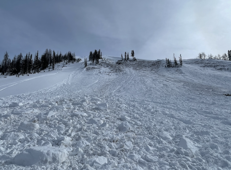
Like an octopus on roller skates... our snowpack is a bit busy right now and sorta complicated as it's juggling a couple different issues-
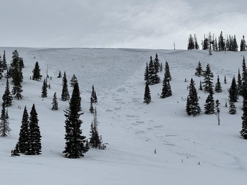
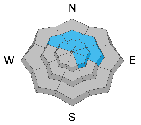
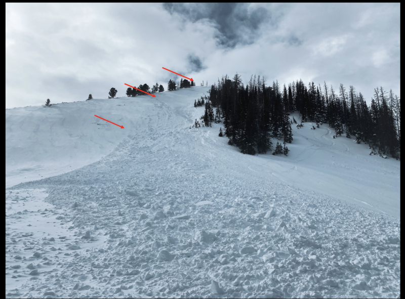
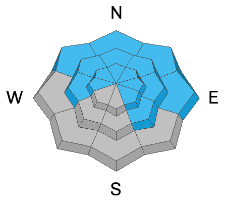
At and above treeline, you'll find CONSIDERABLE avalanche danger. Human triggered avalanches are LIKELY, especially on steep, wind drifted slopes facing the north half of the compass. Remember, we're not out of the woods with older layers, and any slide triggered has the potential to fail on weaker layers of snow, now buried deeply in the snowpack and that'll deliver a season ending avalanche.
In addition, several weak layers varying in thickness, strength, and characteristic lurk in the snowpack near and below treeline around the compass where you'll encounter MODERATE avalanche danger and human triggered slides are POSSIBLE on all aspects.

Here's your exit strategy-
The Uintas have plenty of roly-poly, low angle terrain that isn't steep enough to slide... a great option. With the complexity in the snowpack right now, riding low angle slopes is a solid strategy to avoid avalanches.
Low
Moderate
Considerable
High
Extreme
Learn how to read the forecast here
Special Announcements
We are seeking a passionate individual to join us as Executive Director of the nonprofit Utah Avalanche Center. Click here for more information.
Also... please join the UAC and Inspired Summit Adventures for the grand opening of our new Transceiver Training Park at Pinebrook, Sunday, February 25, from 3:00-6:00PM.
Weather and Snow
Nowcast- Under mostly cloudy skies, light snow is falling, temperatures register in the upper 20's and low 30's, and winds blow 30-50 mph near the high peaks from the south and southwest. A nice reset overnight delivered a mostly uniform 4" of fresh snow across the range, with a few favored areas stacking up close to 6". In either case, snow densities run slightly higher than usual, yet are still the envy of our coastal brethren and sistren, registering in the 10% range... so right around .50" H2O.
Forecast- It'll be warm, wet, and windy as several bands of moisture slide through the area today, some of them producing heavy snow. I think an additional 6" of snow during the day seems reasonable. High temperatures climb into the mid 30's and southwest winds blow in the 40's and 50's, with gusts to 70 mph near the high peaks.
Futurecast- A good slug of moisture settles in overnight and the storm gets going on Wednesday when cold air slides through the region. 12"-18" of total snow feels like a solid bet before snow tapers off late Thursday, exits the area and delivers mostly sunny skies to wrap up the workweek.
Our good friends and longtime partners at Salt Lakes NWS issued a Winter Weather Advisory for the Uinta zone.
Recent Avalanches
Avy-savvy, Inspired Summit Adventure guide Wes Shirey noted yet another large, natural slide near Wolf Creek in Neeley Bowl. Southerly winds light this place up and yesterday was no exception. Breaking 4' deep and 200' wide, this slide is a repeater and failed on weak, old, sugary snow. More deets found HERE.
But wait... there's more! Don't forget about yet two other very large slides breaking near the ground just last week. One natural slide was found in the Wolf Creek area (3-4' deep and 200' wide), and another snowmobile-triggered slide in upper Chalk Creek that buried a rider.

For all Uinta observations and recent avalanche activity click HERE.
Ad
Avalanche Problem #1
Wind Drifted Snow
Type
Location
Likelihood
Size
Description
Blowing left to right in the image above, wind transports snow onto a steep, leeward slope which just needed a little thump in the right place to trigger this slide just which was packin' some heat as it crashed down on the slope below.
Winds have been all over the place and now have some storm snow to work with, whipping up a fresh round of drifts that'll be reactive to our additional weight. Found mostly on the leeward side of upper elevation ridges, I wouldn't be too surprised to find drifts forming around terrain features like chute snd gullies.
Avalanche Problem #2
New Snow
Type
Location
Likelihood
Size
Description
Recent new snow stacks up on a variety of old snow surfaces and is becoming more reactive as it settles into a cohesive storm slab. Marks highlights the situation above.
The new snow that piled up since early February may fracture and produce a slab avalanches 1-3 feet deep. On Sunday, riders near Wall Lake triggered many shallow soft slabs as they wisely tested small slopes to get information about conditions. As more snow stacks up today, new snow slabs dot the landscape and may become more reactive to our additional weight, especially as the day wares on .
On shaded slopes, there is layer of buried surface hoar about 3 feet deep. It is not everywhere; however, Mark found it last weekend near Smith and Morehouse and on Saturday near Iron Mine Mountain.We haven't gotten any reports of avalanches on this layer, but it's hard to ignore.
On sunny slopes, there may be a thin layer of facets on top of an heat crust that was buried 12"-18" deep on Valentine's day. We still need to hunt for this layer and could use your help... so let us know what your finding. However, with widespread avalanche activity on this layer in other places as well as two suspicious slides near Long Lake, we consider it guilty until proven otherwise.
Avalanche Problem #3
Persistent Weak Layer
Type
Location
Likelihood
Size
Description
Old layers of faceted snow near the ground can still produce a hard slab avalanche like one last weekend in upper Chalk Creek (
Even though the odds of triggering one of these slides have gone way down, the consequences remain severe. Common terrain theme is.... steep, rocky, north facing terrain with a thin, weak snow pack are likely suspects. You can trigger a deep, nasty slide form a thin portion of the snowpack like around a rock or bush, barely hidden under the snow.
Becoming more the exception of the rule, I wouldn't take my eyes of the prize... once triggered, these are season ending avalanches
Additional Information
The Uinta weather station network was upgraded this summer and all that real-time info is found HERE. Simply click on "western Uinta" tab and then "weather stations" tab.

We are always looking for snow and avalanche observations or just general riding conditions. So... if you see something, say something. You can reach me directly at [email protected] or 801-231-2170.
Also, if you're looking for more avy education opportunities for yourself, your crew, or your club please don't hesitate to reach out to me and we'll find a presentation, class, or clinic for ya!
General Announcements

Issued at 0400 on Tuesday, February 20th this forecast will be updated by 0700 Wednesday, February 21st, 2024.
This forecast is from the U.S.D.A. Forest Service, which is solely responsible for its content. This forecast describes general avalanche conditions and local variations always occur.