Check out our Holiday Auction - Sign Up for the Utah Snow and Avalanche Workshop (USAW)

Forecast for the Moab Area Mountains

Eric Trenbeath
Issued by Eric Trenbeath on
Monday morning, January 8, 2024
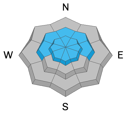
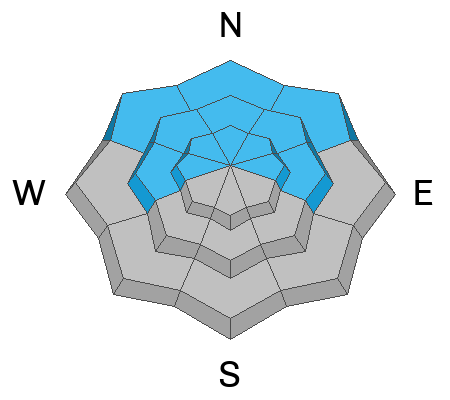
The avalanche danger is CONSIDERABLE on all aspects above tree line, and on northerly facing slopes at mid elevations. Human triggered avalanches are likely in these areas.
On northerly aspects, fresh slabs of wind drifted snow have begun to stress buried weak layers in the snowpack. Avalanches may be triggered from a distance and may break further and wider than expected.

Backcountry travelers need to have excellent route finding skills. Avoid slopes steeper than 30 degrees and avoid avalanche run out zones.
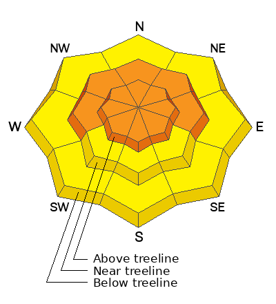
Low
Moderate
Considerable
High
Extreme
Learn how to read the forecast here
Special Announcements
With the arrival of new snow, sign up for our Backcountry 101 course Jan 19, 20!
Sign up for forecast region-specific text message alerts. You will receive messages about changing avalanche conditions, watches, and warnings.
Follow us on Instagram @utavy_moab
Road Conditions: The road will be closed for plowing this morning starting about 9:30.
Grooming: A grooming schedule for dealing with all the new snow is being assembled, check back for details.
Weather and Snow
6:00 a.m. Snow and Weather Data
24 Hour Snow 14" 72 Hour Snow 25" Season Total Snow 64" Base Depth at Gold Basin 40"
Winds on Pre-Laurel Peak: NW 15-20 G 35 Temp 8˚ F

Weather
Cold dry air is being pulled into the area as yesterday's storm system spins off to the east. Winds from the NW were on the increase overnight and will blow in the 20-30 mph range along ridge tops. With a high temps in the low teens, wind chill values will make it feel like -20F. We should see clearing skies today through tomorrow, with the next low pressure system arriving Tue night - Wednesday. This system will favor areas north, but we may squeak out an inch or two. Unsettled weather follows with our next chance for significant snow about a week away.
General Conditions
Deep, light, fluffy powder was the rule yesterday and in spite of all the new snow, water weight was relatively low at 1.0" to 1.2" of Snow Water Equivalent. Wind effects were surprisingly minimal near treeline and below and our man Dave Garcia, reported minimal slab formation in these areas. Above treeline it's a different story and winds have drifted slabs 1'-2' deep on top of a weak, pre-existing snowpack. Sam Van Wetter ventured up there yesterday and reported collapsing and whumphing, a red flag sign of instability that indicates a weak layer failure. This problem is most pronounced on steep, northerly aspects, and it's going to get worse before it gets better. This type of terrain will need to be avoided for some time.
Snowpack and Weather Data
Gold Basin Storm Stake (10,000')
Gold Basin SNOTEL site (10,000')
SNOTEL site near Geyser Pass Winter Trailhead (9600')
Wind Station on Pre-Laurel Peak (11,400')
NWS forecast for the La Sal Mountains.
Ad
Avalanche Problem #1
Wind Drifted Snow
Type
Location
Likelihood
Size
Description
Human triggered avalanches within the new and wind drifted snow remain likely on all aspects today. Increasing NW winds will deposit snow on to southerly aspects while crosssloading northerly facing slopes. On northerly facing slopes, winds over the past few days have drifted snow into slabs 1'-2' deep. These drifts will be adding stress to buried weak layers in the snowpack increasing the likelihood for deeper and more dangerous avalanches on these aspects.
Avalanche Problem #2
Persistent Weak Layer
Type
Location
Likelihood
Size
Description
By now you know that we have a weak and deteriorating snowpack on northerly aspects with a variety of persistent weak layers. Blowing and drifitng of the most recent snow has built slabs 1'-2' thick over top of this weak snowpack and dangerous, human triggered avalanches breaking into old snow are likely in these areas. This problem will be with us for some time, and we may as well get in the mindset that this type of terrain is to be avoided for the foreseeable future.
Additional Information
To fulfill our mission, the UAC relies on our amazing backcountry community. Your support helps pay for the daily avalanche forecast, free awareness presentations across the state, and new tools like the new Avalanche and Observation Explorer. As we welcome the new year, please consider donating to the UAC.
General Announcements
This forecast is from the U.S.D.A. Forest Service, which is solely responsible for its content. This forecast describes general avalanche conditions and local variations always occur.