Check out our Holiday Auction - Sign Up for the Utah Snow and Avalanche Workshop (USAW)

Forecast for the Skyline Area Mountains

Brett Kobernik
Issued by Brett Kobernik on
Sunday morning, December 10, 2023
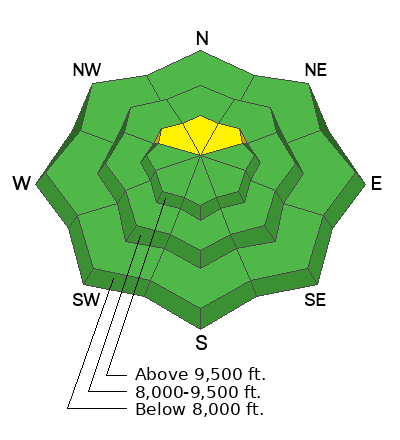
The avalanche danger is slowly decreasing and most of the terrain has a LOW danger rating. The danger rating is MODERATE in upper elevation more northerly facing terrain where a human triggered avalanche is still possible.
Low
Moderate
Considerable
High
Extreme
Learn how to read the forecast here
Weather and Snow
Current Conditions: Temperatures are on the rebound with readings around 20˚F this morning. Wind from the west northwest has increased slightly with moderate speeds along the more exposed terrain.
Mountain Weather: We'll have mostly sunny skies today, moderate speed northwest wind, and high temperatures around 30˚F. The rest of the week looks very similar with lighter wind speeds. There really is no significant storm on the horizon right now.
Ad
Avalanche Problem #1
Persistent Weak Layer
Type
Location
Likelihood
Size
Description
A layer of weak sugary faceted snow near the ground is still cause for concern. Although locations for triggering an avalanche are getting more and more spotty, it's difficult to identify which slopes will slide and which won't. The best mitigation technique is to avoid suspect slopes which are steep, high, north facing.
As we go into a period with no storms, we will watch the snowpack slowly deteriorate. All of the snow that is on the ground will slowly start getting more sugary. This could lead to a more widespread Persistent Weak Layer avalanche problem when storms start coming again. Stay tuned.
General Announcements
This forecast is from the U.S.D.A. Forest Service, which is solely responsible for its content. This forecast describes general avalanche conditions and local variations always occur.