Check out our Holiday Auction - Sign Up for the Utah Snow and Avalanche Workshop (USAW)

Forecast for the Skyline Area Mountains

Brett Kobernik
Issued by Brett Kobernik on
Saturday morning, December 9, 2023
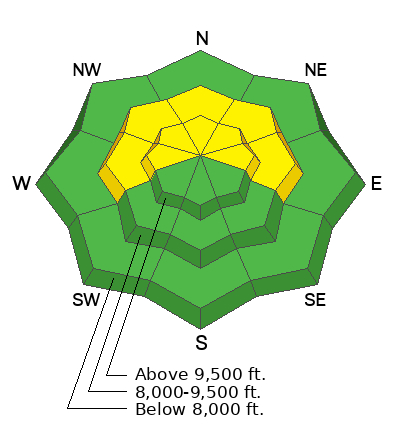
The overall avalanche danger for the Skyline today is MODERATE. Human triggered avalanches 2 to 3 feet deep are possible especially in the upper elevation more northerly facing terrain where wind has drifted the new snow. The problem is a Persistent Weak Layer of loose, sugary faceted snow near the base of the snowpack in the more northerly facing terrain. This will be a concern for some time to come.
Low
Moderate
Considerable
High
Extreme
Learn how to read the forecast here
Special Announcements
The 5th Annual Avalanche Awareness Week is December 3-10. The week's goal is to save lives through activities that promote avalanche awareness, education, and safety. We have a variety of events around the state. Find an event near you.
Weather and Snow
Current Conditions: Light snowfall continued through Friday with an inch or two of powder after the wind died down. This brings storm totals to about 5 inches. Temperatures are in the single digits. It was moderately windy from the west northwest on Friday but the wind has slowed. Although the snowcover is shallow, the new snow should provide some nice riding conditions.
Mountain Weather: We have clouds hanging over the mountains this morning but they should start to break up today. Temperatures will get into the mid teens. Wind will be light from the west northwest. Temperatures rebound Sunday and Monday getting into the low 30s. This morning, the long term forecast looks pretty sad with no significant storms over the next couple of weeks.
Ad
Avalanche Problem #1
Persistent Weak Layer
Type
Location
Likelihood
Size
Description
A Persistent Weak Layer of faceted snow near the ground is really our only concern. There is enough snow on top of it to produce slab avalanches. The problem is most pronounced in the higher elevation more northerly facing terrain. It is still a concern but less pronounced on more west or east facing terrain and less pronounced in the mid elevations. There is not much concern at lower elevations as well as on southerly facing slopes.
With no storms in sight, this problem will become less dangerous over the next week. It will likely become "dormant" where there won't be any avalanche threat. However, whenever we get significant snow again, it will most likely become active again.
My fear is that if we go two weeks without any significant snow, all of the snow that is currently on the ground is going to deteriorate and turn into sugary facets. If this happens, the problem will probably be more widespread than it is now and dangerous avalanche conditions are sure to follow when we get storms.
General Announcements
This forecast is from the U.S.D.A. Forest Service, which is solely responsible for its content. This forecast describes general avalanche conditions and local variations always occur.