Forecast for the Skyline Area Mountains

Brett Kobernik
Issued by Brett Kobernik for
Wednesday, March 22, 2023
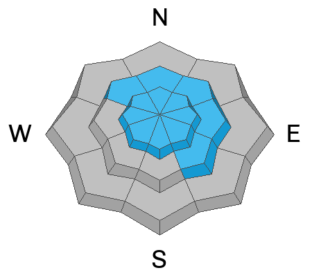
There is a MODERATE avalanche danger rating in the mid and upper elevation steep terrain.
Areas of wind drifted snow will form today and will be the most likely places to trigger an avalanche.
Avoid slopes steeper than 30˚ where the wind is drifting and depositing snow.
Low
Moderate
Considerable
High
Extreme
Learn how to read the forecast here
Weather and Snow
Current Conditions: Riding conditions were very nice on Tuesday. With a solid foot of new snow or a bit more resting on soft underlying snow, it felt deep. There is eleven feet of settled snow at Fairview Lakes. The Meadows snotel weather station in Ephraim Canyon hit 100 inches of settled snow. We picked up a trace to a few inches of snow overnight. Temperatures have been hovering in the mid 20s for the last 24 hours. The wind has been generally light. It was from the east on Tuesday and is now from the southwest.

Mountain Weather: We'll see periods of snow today. I'm not confident on how much to expect. One weather model suggests we'll get up to a foot. Another suggests only a few inches. My best estimate is we'll see 4 to 8 inches of new snow over the next 24 hours. Wind from the southwest is going to be a bit strong for a while today. Temperatures should remain in the mid 20s. We have another chance for snow late Thursday then another colder system moving through late Friday. These systems don't look huge but will bring more measurable snow.
Ad
Avalanche Problem #1
New Snow
Type
Location
Likelihood
Size
Description
The new snow will be accompanied by some stronger wind today which will form fresh drifts and slabs. These will most likely be sensitive as they are forming. A few could release naturally. The most likely places for these to form will be on northwest through southeast facing slopes in the mid and upper elevations.
Your strategy is the same as yesterday:
  • Watch for cracking within the new snow.
  • Hit small but steep test slopes to see if the new snow stays in place. If you do this a bunch of times and the snow stays in place, it indicates stability.
  • Avoid areas with fresh drifts and slabs of wind drifted snow. Drifts are always the most sensitive when they are forming and directly after. It's too soon to trust that these wind slabs will stay in place.
If you are really concerned about triggering an avalanche, simply avoid being on or below slopes that are steeper than 30˚.
General Announcements
This forecast is from the U.S.D.A. Forest Service, which is solely responsible for its content. This forecast describes general avalanche conditions and local variations always occur.