Forecast for the Logan Area Mountains

Toby Weed
Issued by Toby Weed for
Tuesday, February 7, 2023
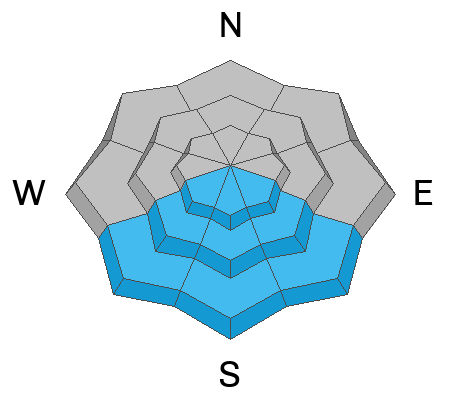
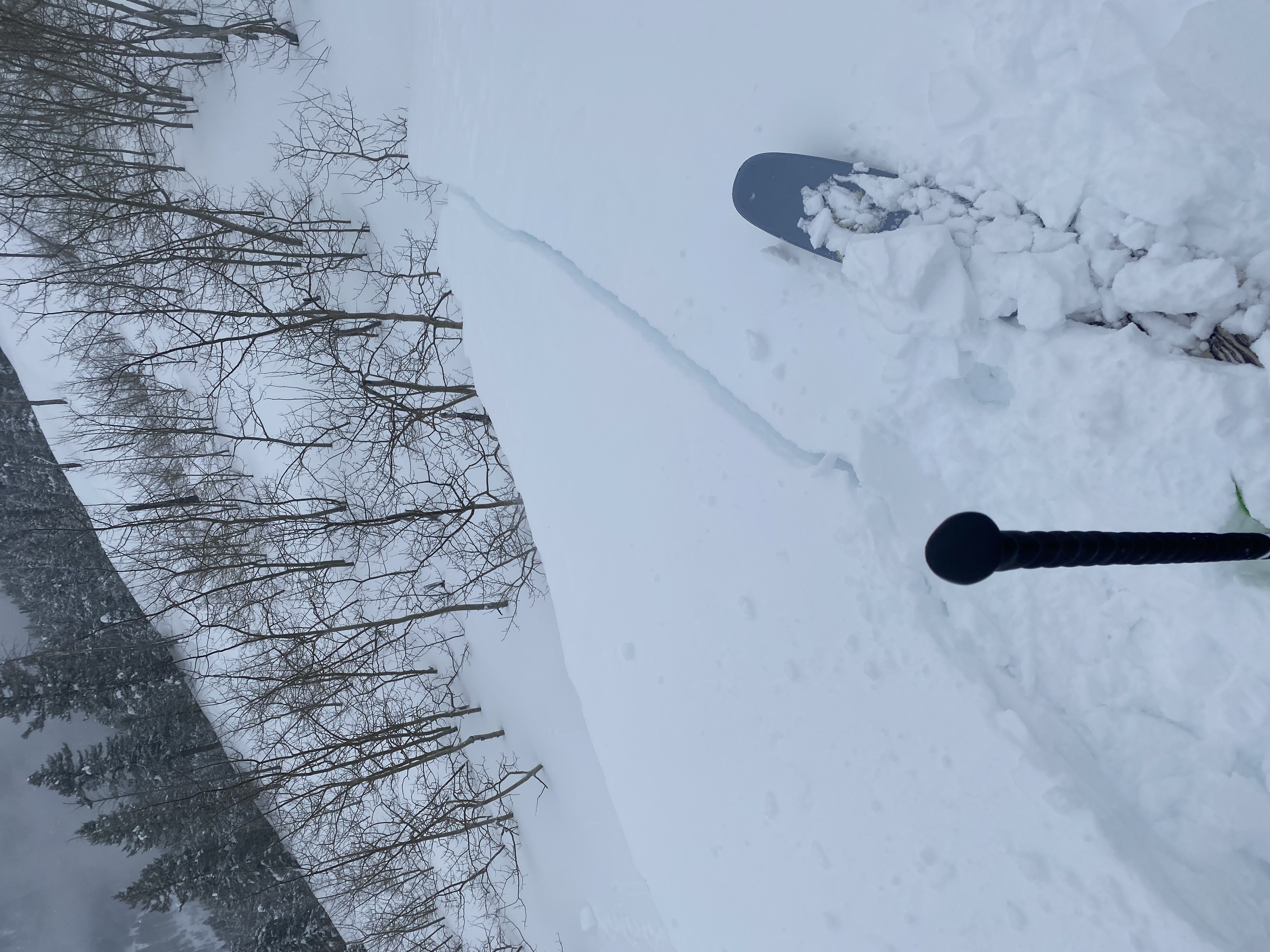
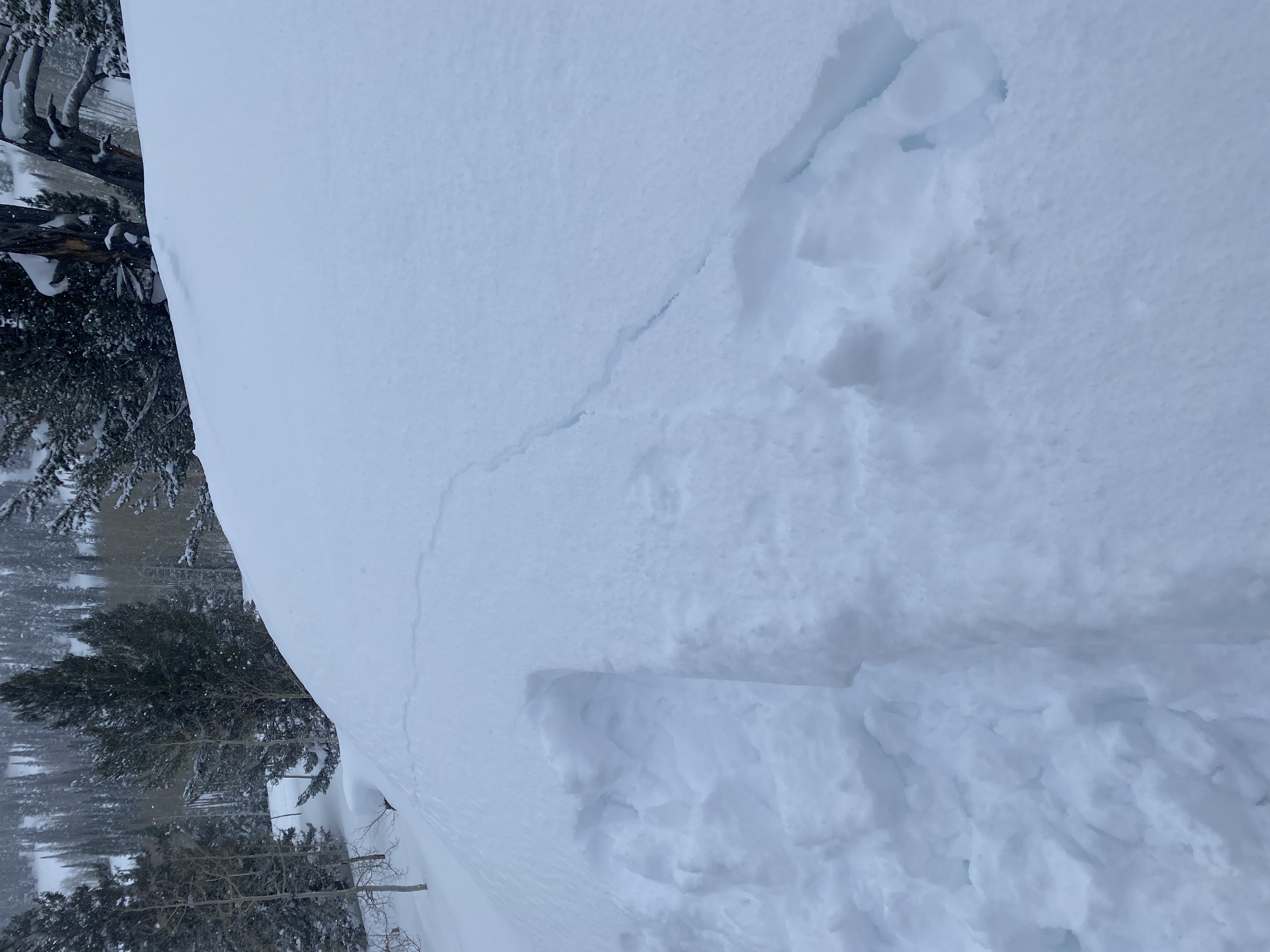
Heightened avalanche conditions exist across the Logan Zone, and the danger is MODERATE on drifted slopes steeper than 30° at all elevations. More new snow fell up high yesterday and potential avalanches will be larger and more likely at upper elevations and on slopes facing the eastern half of the compass. In drifted areas, people could trigger 1 to 3 feet thick slab avalanches, and some of these might be initiated quite easily or even remotely. Loose avalanches entraining moist new snow are possible in the middle of the day on warm sunny slopes.
  • Evaluate snow and terrain carefully.
Low
Moderate
Considerable
High
Extreme
Learn how to read the forecast here
Weather and Snow
Winds at the CSI Logan Peak weather station are blowing from the northwest at around 25 mph, and temperatures dropped to 13° F at 9700'. The Tony Grove Snotel at 8400' reports 18° F, 11 inches of new snow from the recent storm and 102 inches of total snow.

Today will be party sunny. Expect high temperatures around 25° F and moderate winds blowing from the west.
Tonight will be mostly cloudy, with low temperatures around 14° F and increasing west winds.
We could see a bit of snow on Wednesday with 3 to 7 inches possible and increasingly strong winds blowing from the west-northwest.
The rest of the week and heading into the weekend will bring fairly quiet weather with some clouds and continued cool temperatures
Recent Avalanches
A close call occurred Sunday near Willard Peak in the Ogden Zone at 7600' in elevation when two skiers were caught, carried, and partially buried by an avalanche of wind drifted snow...HERE
Locally: Skiers reported coming across recent natural avalanches in the Mt. Naomi Wilderness on Sunday. No avalanches were reported yesterday, but observers report extensive cracking and intentionally triggered large cornice falls. Friday a skier easily triggered an avalanche of wind drifted snow near the ridge in upper Logan Dry Canyon.
For a list of local avalanches go HERE Find a list of all recent observations & avalanches from across Utah HERE.
Ad
Avalanche Problem #1
Wind Drifted Snow
Type
Location
Likelihood
Size
Description
Recent winds built stiffer slabs on weak surface snow consisting of small-grained faceted snow and perhaps surface hoar. There are also areas where deeper buried persistent weak layers are present. Last night and this morning the winds are out of the northwest and plenty strong enough to drift the several inches light new snow into soft and harder wind slabs. I found drifts and plenty of loose sugary snow as well as crusts at lower elevations in Blacksmith Fork Canyon yesterday, but more snow accumulated at higher elevations and sustained winds from the northwest mean that avalanches will be larger and more likely at upper elevations and on easterly facing lee slopes.
  • Fresh wind slabs having formed on weak surface snow are likely to be pretty sensitive to human triggers, and some avalanches today might be remotely triggered, from a distance.
  • Avoid corniced slopes and stiffer drifts on steep slopes near ridges and in and around terrain features like cliff bands, sub-ridges, mid-slope break-overs, and gully walls.
  • The fresh drifts are pretty obvious today but don't be fooled into trusting them, and fresh powder today could hide some of the older drifts. Some formed on weak surface snow and could be quite sensitive, while other's (harder wind slabs) may allow a person to get well out on them before releasing like a mouse trap.
  • The good news is that refreshed shallow powder riding conditions are excellent in lower angled, lower elevation, and sheltered terrain.
Avalanche Problem #2
New Snow
Type
Location
Likelihood
Size
Description
Small soft slab and loose avalanches of new snow are possible for people to trigger, even in more sheltered steep terrain. These will be more likely and larger on upper elevation slopes with more fresh accumulations, so probably larger up high and smaller down low. Loose avalanches entraining wet snow may become possible in sunny terrain as the new snow is warmed and the surface becomes moist. Sheltered south facing slopes can act like solar ovens, creating much hotter temperatures than elsewhere. (The big south facing slopes in Cub River, Hillyard Canyon, the Mount Naomi Wilderness and Wood Camp come to mind locally...)
  • Even small avalanches can be dangerous if you are swept into trees or other terrain traps
  • Loose wet avalanches can entrain large piles of moist fresh snow and run far on sustained slopes
Additional Information
Potential booby traps exist in the backcountry, cornices and stiffer wind slabs that formed on weak surface snow. This from yesterday in the backcountry near Beaver Mountain. (Schumacher)
General Announcements
  • Please submit your observations from the backcountry HERE.
  • For a list of avalanche classes from the Utah Avalanche Center go HERE
  • For information on where you can ride your sled or snowbike, check out this map of the winter travel plan for the Logan and Ogden Ranger Districts HERE, and a close up of the Tony Grove and Franklin Basin Areas HERE.
This forecast is from the U.S.D.A. Forest Service, which is solely responsible for its content. This forecast describes general avalanche conditions and local variations always occur.