Forecast for the Logan Area Mountains

Toby Weed
Issued by Toby Weed for
Monday, February 6, 2023
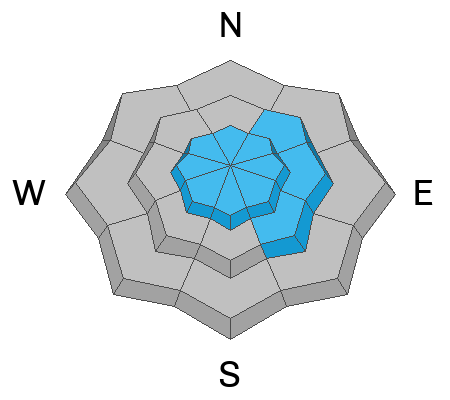
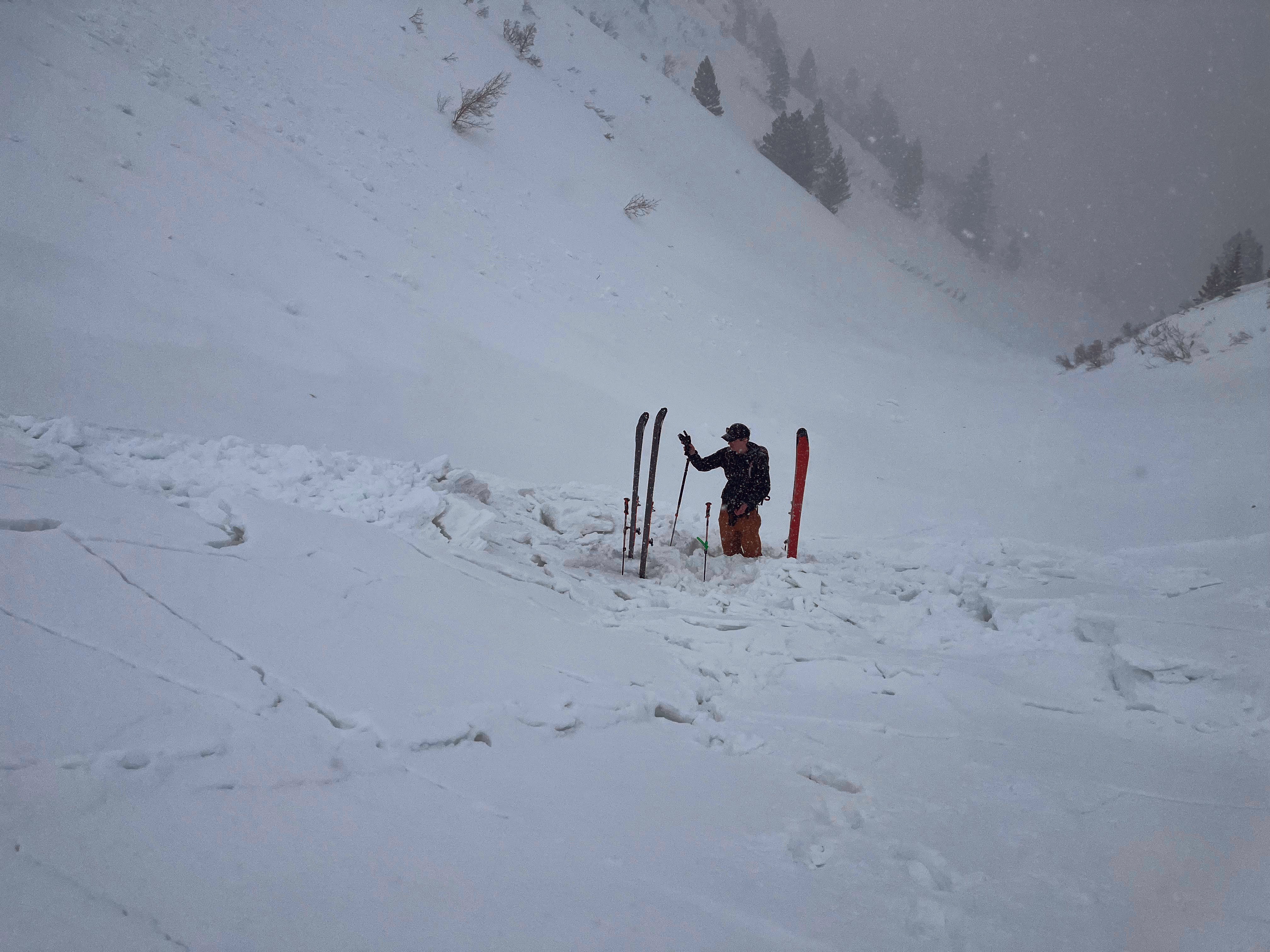
Heightened avalanche conditions exist across the Logan Zone, and the danger is CONSIDERABLE on drifted upper elevation slopes. In drifted areas, people could trigger 1 to 3 feet thick slab avalanches, and some of these might be initiated quite easily or even remotely. Small soft slab and loose avalanches of storm snow are possible on slopes steeper than 30° at all elevations.
  • Make conservative decisions and evaluate snow and terrain carefully.
Low
Moderate
Considerable
High
Extreme
Learn how to read the forecast here
Weather and Snow
Winds at the CSI Logan Peak weather station increased again early this morning and are blowing from the west-northwest at around 25 mph, and temperatures dropped to 13° F at 9700'. Beaver Mountain reports 6" of new snow in the last 24 hours and there is around 8 feet of total snow at and above around 8500' in the Central Bear River Range.

The National Weather Service has a Winter Weather Advisory through this afternoon. Expect snow to taper off today, with 3 to 5 inches of additional accumulation possible on upper elevation slopes, high temperatures at 8500' will top out around 22° F, with fairly strong winds continuing from the west-northwest.
Tonight will be mostly cloudy, with low temperatures around 11° F and 15 mph wind blowing from the north-northwest.
Tuesday will be mostly sunny. Expect high temperatures around 24° F and moderate winds blowing from the west.
We could see a little snow on Wednesday, but otherwise it looks like a quiet week weather-wise, with some sun but continued cold temperatures.
Recent Avalanches
A close call occurred yesterday near Willard Peak in the Ogden Zone at 7600' in elevation when two skiers were caught, carried, and partially buried by an avalanche of wind drifted snow...HERE
Locally: A skier took one step out onto a recently drifted north facing slope on Friday and easily triggered an avalanche of wind drifted snow near the ridge in upper Logan Dry Canyon.
We've counted a handful of human triggered avalanches and dozens of large natural avalanches in the Logan Zone in the past week. For a list of local avalanches go HERE

Find a list of all recent observations & avalanches from across Utah HERE.
Ad
Avalanche Problem #1
Wind Drifted Snow
Type
Location
Likelihood
Size
Description
Recent winds built stiffer slabs on weak surface snow consisting of small-grained faceted snow and perhaps surface hoar. Last night and this morning the winds are out of the west-northwest and plenty strong enough to drift the several inches light new snow into soft and harder wind slabs.
Fresh wind slabs having formed on weak surface snow are likely to be pretty sensitive to human triggers, and some avalanches today might be remotely triggered, from a distance.
  • Avoid corniced slopes and stiffer drifts on steep slopes near ridges and in and around terrain features like cliff bands, sub-ridges, mid-slope break-overs, and gully walls.
  • The fresh drifts are pretty obvious today but don't be fooled into trusting them, and fresh powder today could hide some of the older drifts. Some formed on weak surface snow and could be quite sensitive, while other's (harder wind slabs) may allow a person to get well out on them before releasing like a mouse trap.
  • The good news is that refreshed shallow powder riding conditions will be excellent in lower angled, lower elevation, and sheltered terrain.
Avalanche Problem #2
New Snow
Type
Location
Likelihood
Size
Description
Small soft slab and loose avalanches of new snow are likely for people to trigger, even in more sheltered steep terrain. These will be more likely and larger on slopes with more fresh accumulations, so probably larger up high and smaller down low.
  • even small avalanches can be dangerous if you are swept into trees or other terrain traps
Additional Information
Potential booby traps exist in the backcountry, stiffer wind slabs that formed on weak surface snow. This from Sunday in the Ogden Zone on a 35° east facing slope at 7600'
General Announcements
  • Please submit your observations from the backcountry HERE.
  • For a list of avalanche classes from the Utah Avalanche Center go HERE
  • For information on where you can ride your sled or snowbike, check out this map of the winter travel plan for the Logan and Ogden Ranger Districts HERE, and a close up of the Tony Grove and Franklin Basin Areas HERE.
This forecast is from the U.S.D.A. Forest Service, which is solely responsible for its content. This forecast describes general avalanche conditions and local variations always occur.