Forecast for the Logan Area Mountains

Toby Weed
Issued by Toby Weed for
Wednesday, February 8, 2023
Heightened avalanche conditions exist in the backcountry, and the danger is MODERATE on drifted slopes steeper than 30°. People could trigger 1 to 3 feet thick slab avalanches of wind drifted snow. The snow is mostly stable at low elevations and where it is not affected by the wind. Today, periods of heavy snow and drifting by increasingly strong winds from the west will cause the avalanche danger to rise. Areas of CONSIDERABLE danger could develop on drifted upper elevation slopes later this afternoon.
  • Evaluate snow and terrain carefully.
Low
Moderate
Considerable
High
Extreme
Learn how to read the forecast here
Weather and Snow
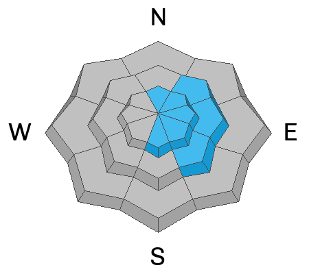
Heightened avalanche conditions exist currently in drifted terrain where people could trigger avalanches of wind drifted snow, but the danger is much less where the snow was not affected by the wind. I found stable conditions and nice fast shallow powder in sheltered terrain in the Central Bear River Range yesterday, with the best riding in lower angle terrain. Expect a windy storm today with periods of heavy snow, but mainly blowing snow causing increasing avalanche danger.
Winds at the CSI Logan Peak weather station are blowing from the west at around 27 mph, and it's 17° F at 9700'. The Tony Grove Snotel at 8400' reports 21° F and 99 inches of total snow.

Today, snow is likely with 4 to 8 inches of accumulation possible on upper elevation slopes. Expect increasingly strong winds blowing from the west, high temperatures around 21° F, and wind chill values as low as -7° F.
Tonight, snow should taper off and It'll be mostly cloudy and windy, with low temperatures around -1° F and gradually decreasing north winds producing wind chill values around -15° F.
Tomorrow will be mostly sunny and cold, with wind chill values starting out as low as -17° F. High temperatures are expected to reach 21° F, and northwest winds will switch around from the west-southwest in the afternoon.
The rest of the week and heading into the weekend will bring fairly quiet weather with some sun, a few clouds, and continued cool temperatures with daytime highs staying below freezing in the mountains.
Recent Avalanches
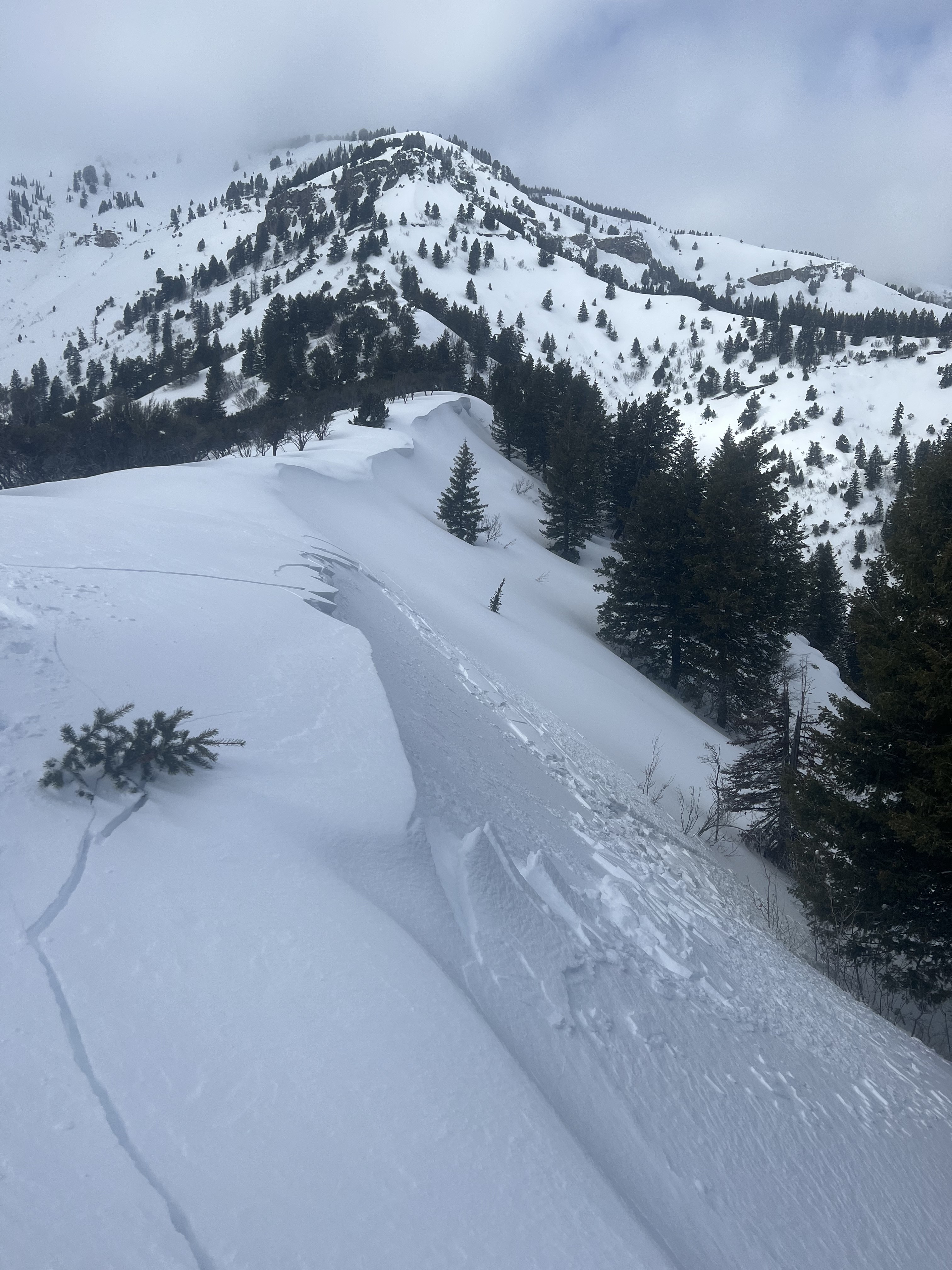
No significant avalanches were reported this week, but observers report extensive cracking in wind affected terrain and a few small wind slab avalanches.

For a list of local avalanches go HERE Find a list of all recent observations & avalanches from across Utah HERE.
Ad
Avalanche Problem #1
Wind Drifted Snow
Type
Location
Likelihood
Size
Description
Periods of heavy snow are likely today, with several inches of accumulation possible. But, the big story will be the increasingly strong winds blowing from the west even as the snow is falling. Today's strong winds out of the west will be more than strong enough to drift existing powder and today's new snow into soft and harder wind slabs. Significant drifting is possible, and it will cause rising avalanche danger in exposed terrain at all elevations, especially up high. Recent winds built stiffer slabs on weak surface snow consisting of small-grained faceted snow and perhaps surface hoar. These are fairly shallow but remain sensitive, with shooting cracks observed yesterday. Although easy to forget about, there are also areas where deeper buried persistent weak layers are present.
  • Fresh wind slabs having formed on weak surface snow are likely to be pretty sensitive to human triggers, and some avalanches today might be remotely triggered, from a distance.
  • Avoid corniced slopes and stiffer drifts on steep slopes near ridges and in and around terrain features like cliff bands, sub-ridges, mid-slope break-overs, and gully walls.
  • The good news is that shallow powder riding conditions remain excellent in lower angled, lower elevation, and sheltered terrain.
Additional Information
Potential booby traps exist in the backcountry, cornices and stiffer wind slabs that formed on weak surface snow. This from yesterday in Wood Camp. (Benson)
General Announcements
  • Please submit your observations from the backcountry HERE.
  • For a list of avalanche classes from the Utah Avalanche Center go HERE
  • For information on where you can ride your sled or snowbike, check out this map of the winter travel plan for the Logan and Ogden Ranger Districts HERE, and a close up of the Tony Grove and Franklin Basin Areas HERE.
This forecast is from the U.S.D.A. Forest Service, which is solely responsible for its content. This forecast describes general avalanche conditions and local variations always occur.