Join us at our 2nd Annual Blizzard Ball

Forecast for the Uintas Area Mountains

Nikki Champion
Issued by Nikki Champion on
Monday morning, November 28, 2022
This morning the overall avalanche danger is LOW rising to MODERATE as the storm develops.

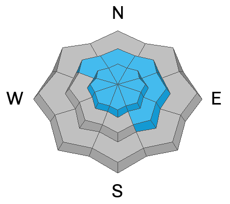
The danger will rise to MODERATE on all upper-elevation slopes and mid-elevation NW, N, NE, E, and SE facing slopes where today’s new snow may produce some long-running sluffs, and possibly some soft slab avalanches where the new snow rests on old, weak faceted snow.
Additionally, the elevated wind may create small unstable slabs of wind-drifted snow.

There is still a significant danger of hitting rocks, stumps, and other obstacles. These hazards will be hard to see, but they will be easy to hit as they become covered with new snow. Go slow and be careful.
Low
Moderate
Considerable
High
Extreme
Learn how to read the forecast here
Special Announcements
Join the Utah Avalanche Center and the Division of Outdoor Recreation to celebrate the Fourth Annual Avalanche Awareness week, from December 4 - December 11. Click HERE to view the full list of events for the week.

Mirror Lake Highway is closed for the season. SR-35 (Wolf Creek Pass) remains open.
Weather and Snow
This morning, skies are overcast with a few light flakes falling. Mountain temperatures are currently in the upper teens F to low 20s F. Over the last 12 hours, the southwesterly winds have averaged 15-25 mph at mid-elevations, with some gusts above 50 mph at the uppermost elevation. No measurable accumulation as of 6 AM.
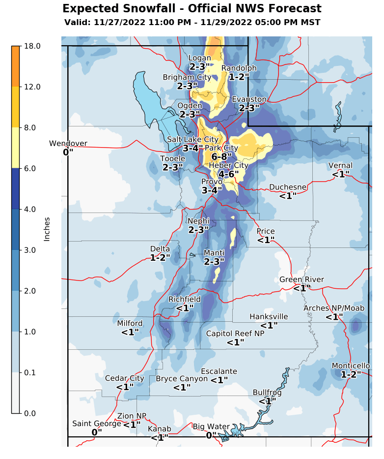
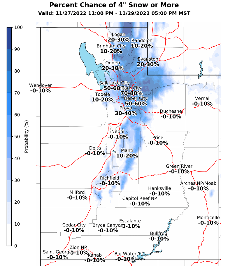
Today, we are finally seeing a change in the weather pattern. This morning a winter weather advisory has been issued for the Western Uinta mountains through tomorrow evening. We could see snow totals between 6-12", with up to 18" of snow possible in favored areas like the Upper Cottonwoods. Skies will remain mostly cloudy with increasing snowfall throughout the day and into the evening. Temperatures will begin dropping into the low teens F. Winds will remain southwesterly averaging 10-20 mph at mid-elevations, and 20-30 mph at upper elevations with gusts up to 50 mph at the highest ridgelines.
This active pattern continues, with increasing southwest flow Thursday ahead of the next round of snow around the Friday timeframe.
Our partners at National Weather Service issued a Winter Weather Advisory for 3:00 AM Nov 28th, until 7:00 PM Nov 29th set to impact the Wasatch Mountains South of I-80 and Western Uinta Mountains. Find more information HERE.

Last week, Mark and I got out in the Wolf Creek Pass Zone. You can find the full observations HERE. Backcountry travel remains generally easy and riding conditions are pretty good for mid-November. Some wind and sun damage exists in the alpine and on the solar aspects, respectively, but sheltered parts hold soft recrystallized snow.
A few key takeaways for the Western Uintas from before the storm:
  • Almost all slopes are snow-covered. The exception is steep, direct south-facing slopes which only have a few inches of snow. All other slopes have varying depths but are well covered.
  • Almost all slopes (except steep, direct south-facing) have lots of facets from top to bottom of the snowpack. The absolute weakest snow is on the surface on the north facing.
This is worth noting, as this snow will soon become the base of our entire snowpack. When we get a slab atop this weak faceted snow, there will be avalanches on nearly all slopes.

Folks have been getting out, and looking at terrain find their insightful observations and trip reports are found HERE.
Recent Avalanches
No recent avalanches reported in the backcountry.
Ad
Avalanche Problem #1
New Snow
Type
Location
Likelihood
Size
Description
As the storm develops the avalanche danger will be rapidly rising. The slopes that we will want to ride, are the slopes that held any snow before this storm system. The issue is, these slopes are exactly the ones where the snow has become weak and faceted, and the new snow likely won’t bond well too.
For this same reason, the new snow should easily sluff and produce small loose snow avalanches, especially during periods of higher snowfall rates. What I'm uncertain about is whether or not the new snow will bond to itself and act as a cohesive slab. The good news is that this new snow should show you obvious signs of instability like collapsing, whumpfing, and shooting cracks. Look for these signs, and if you see them, this is your sign that the new snow has become cohesive and will produce a slab avalanche.
Overall, there is a lot of variability in snow surfaces throughout the backcountry right now. Most aspects hold old weak faceted snow, but some solar slopes have a breakable crust, and true south slopes could possess only dirt. What this means is that while avalanche activity may not be widespread immediately, with the increase in snow and winds, we have all the ingredients for avalanches and we will begin to see them occurring.
Avalanche Problem #2
Wind Drifted Snow
Type
Location
Likelihood
Size
Description
Over the last 24 hours, the southwesterly winds have gusted above 50 mph at upper elevations. These elevated winds will easily transport any new snow we get at mid and upper elevations.
These wind drifts will be generally shallow and isolated to terrain features that allow for drifting new snow to accumulate, such as ridges, sub-ridges, and gullies. These shallow drifts will be more prevalent on Northwest to East to Southeast facing aspects, but do a process called cross-loading these elevated winds could allow for drifting at all aspects in upper elevation terrain. Once these wind slabs form they will most likely rest on weak, faceted, old snow that will make them easy to trigger.
Look for obvious signs of wind-drifted snow, such as pillow-shaped slopes, cracking, and whumpfing, and avoid those slopes
Additional Information
And we've been super busy this summer upgrading the western Uinta weather station network and this real-time info is found HERE (click weather stations, and then on the Western Uinta tab)
Your observations are important, so please let me know what you're seeing... click HERE and contribute to this amazing community-based program
General Announcements
Before it gets too crazy, now is the time to book an avalanche awareness presentation for your group, club, or posse. You can reach Craig directly at 801-231-2170 or [email protected].

This forecast is from the U.S.D.A. Forest Service, which is solely responsible for its content. This forecast describes general avalanche conditions and local variations always occur.