UDOT PLANNED AVALANCHE CLOSURES!!

Forecast for the Uintas Area Mountains

Nikki Champion
Issued by Nikki Champion for
Wednesday, November 23, 2022
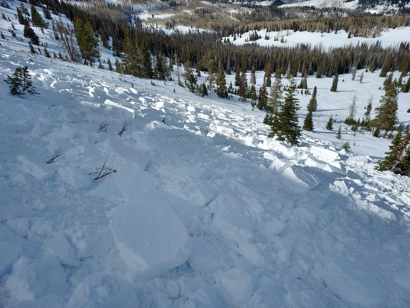
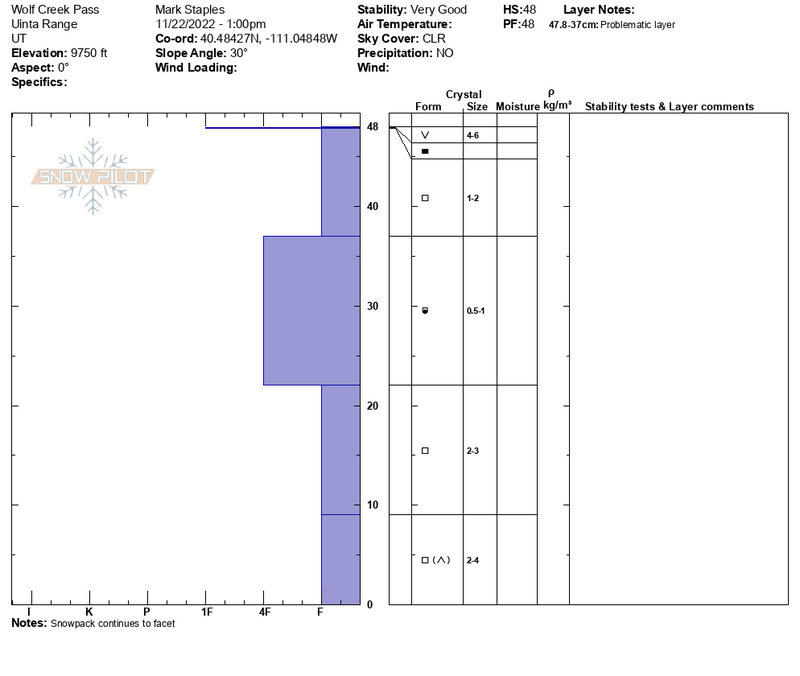
Today, the snowpack is generally stable and avalanches are unlikely. However, with a few inches of new snow and elevated winds, shallow dry loose avalanches, as well as small slabs of wind-drifted snow will be something to think about.
Small avalanches are possible in isolated areas or extreme terrain. Remember that risk is inherent in mountain travel.

We will be issuing intermittent updates and publishing backcountry observations as they arrive. When we begin regular forecasts, we will begin issuing avalanche danger ratings.
Low
Moderate
Considerable
High
Extreme
Learn how to read the forecast here
Special Announcements
Join the Utah Avalanche Center and the Division of Outdoor Recreation to celebrate the Fourth Annual Avalanche Awareness week, from December 4 - December 11. Click HERE to view the full list of events for the week.
Mirror Lake Highway is closed for the season. SR-35 (Wolf Creek Pass) remains open.
Weather and Snow
This morning, skies are overcast with light to moderate snowfall. Mountain temperatures are currently in the upper teens F to low-twenties F. Over the last 12 hours, the westerly winds have averaged 20-30 mph at mid-elevations, with some gusts near 60 mph at the uppermost elevation. No measurable accumulation as of 6 AM.
Today, skies will remain mostly cloudy with the occasional light snowfall. Very little additional accumulation is expected 1 to 2 inches. Temperatures will climb into the mid-twenties F. Winds will remain westerly averaging 10-20 mph at mid-elevations, and 20-30 mph at upper elevations with gusts up to 50 mph at the highest ridgelines.
Looking ahead, an even weaker storm system is expected to graze northern Utah on Saturday. The weather models hint at a pattern change by the end of the month.

Yesterday, Mark and I got out in the Wolf Creek Pass Zone. You can find the full observations HERE. Backcountry travel remains generally easy and riding conditions are pretty good for mid-November. Some wind and sun damage exists in the alpine and on the solar aspects, respectively, but sheltered parts hold soft recrystallized snow.
While it may seem like nothing is happening, a lot is happening within the snowpack. The cold and clear skies have not only promoted weakening in all layers of the snowpack through a process known as faceting, but these atmospheric conditions have been conducive for surface hoar, the wintertime equivalent of dew, deposition on many slopes. I use the word deposition with care: whereas faceting and weakening take place within the snowpack, surface hoar is deposited onto the snow surface. It all makes for soft, turnable snow now, once we get a large load of snow on top of it, the weak faceted snow and surface hoar often become a weak layer down the road.
A few key takeaways for the Western Uintas:
  • Almost all slopes are snow covered. The exception is steep, direct south-facing slopes which only have a few inches of snow. All other slopes have varying depths, but well covered.
  • Almost all slopes (except steep, direct south-facing) have lots of facets from top to bottom of the snowpack. The absolute weakest snow is on the surface on north facing.
This is worth noting, as this snow will soon become the base of our entire snowpack. When it snows, there will be avalanches on nearly all slopes.

Folks have been getting out, and looking at terrain find their insightful observations and trip reports are found HERE.
Recent Avalanches
On November 12th, Micheal J remotely triggered a sizeable piece of snow in the NW-facing bowl of Wolf Creek. Breaking 16" deep x 200' wide, the hard wind slab broke on a thin layer of faceted snow formed 11/3, right before the big storm.
Find Micheal J's thoughts and more information on this slide HERE.
Ad
Avalanche Problem #1
Normal Caution
Type
Location
Likelihood
Size
Description
The current snowpack is generally stable and human-triggered avalanches are unlikely, but small avalanches in isolated areas are still possible.
  • We could see a few shallow dry loose avalanches in steep upper terrain where the eldest snow lingers.
  • With the elevated winds today into tonight you may be able to find an isolated pocket of wind-drifted snow in exposed, upper-elevation terrain. Pay attention to any signs of wind drifted snow such as rounded or pillow-shaped features.
Remember, even a small avalanche can be deadly in consequential terrain.

November 22nd Field Day, finding weak snow on nearly every aspect throughout the snowpack. Find full observation HERE.
Snowpilot from November 22nd Field Day.
Additional Information
And we've been super busy this summer upgrading the western Uinta weather station network and this real-time info is found HERE (click weather stations, and then on the Western Uinta tab)
Your observations are important, so please let me know what you're seeing... click HERE and contribute to this amazing community-based program
General Announcements
Before it gets too crazy, now is the time to book an avalanche awareness presentation for your group, club, or posse. You can reach Craig directly at 801-231-2170 or [email protected].

This forecast is from the U.S.D.A. Forest Service, which is solely responsible for its content. This forecast describes general avalanche conditions and local variations always occur.