UDOT PLANNED AVALANCHE CLOSURES!!

Forecast for the Salt Lake Area Mountains

Drew Hardesty
Issued by Drew Hardesty on
Sunday morning, November 6, 2022
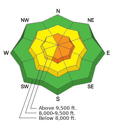
Areas of CONSIDERABLE danger exist on steep wind drifted slopes in the upper elevations. Human triggered avalanches are likely, particularly on north to east to south facing slopes. A MODERATE danger exists on all other aspects and all aspects of the mid-elevations. There will be a trend toward increasing stability over the course of the day.
Remember that early season conditions exist: traumatic injury is possible with any avalanche involvement.
Low
Moderate
Considerable
High
Extreme
Learn how to read the forecast here
Special Announcements
Many ski areas are now closed to uphill travel in order to prepare for winter operations. Resort uphill travel policies can be found HERE>.
Mill Creek Canyon Road will be closed November 8-10th for road work.
Weather and Snow
It felt downright Cascadian in the mountains yesterday, but THIS was another good base-building storm for the Wasatch Range. Yesterday's 3-6" of heavy dense snow was followed by another 4-6" of lower density snow overnight. It's still lightly snowing. Storm totals are below. Skiing and riding conditions will be excellent today although early season conditions still exist. Base depths are 2-3'. Mountain temperatures are in the mid to upper teens with winds blowing 15-20mph from the west. The highest anemometers are spinning 45mph with gusts to 60.
Storm totals:
Little Cottonwood: 8-12"/1.17"-1.30" SWE (snow water equivalent)
Big Cottonwood: 6-8"
Park City ridgeline: 4-8"
Ogden mountains: 8-12"/1.50"-2.0"SWE
Provo mountains: 6-8"/1.15"SWE

For today, expect light snow showers with mountain temperatures rising to the upper 20s up high, the mid 30s down low. Winds will back to the southwest and lose steam until the afternoon. By then, we can expect winds to pick up again with hourly averages of 20-30mph, a hint of what's to come.
A large Pacific storm churning off the coast will move inland and bring heavy snowfall and strong winds to the state early Tuesday through Thursday. Early forecasts suggest upwards of 2'+ of snow for the mid-week storm.
Recent Avalanches
One observer noted a natural soft slab avalanche yesterday 6-8" deep on a northeast facing slope at 9500'. Of greater concern to me, however, was a report of a large collapse and shooting cracks high on north facing Sunset Peak in the upper reaches of Big Cottonwood canyon. This hints at weak, older faceted snow still lingering in the high thin shady terrain.

Snowpack situation: We are building a good solid foundation in nearly all of our terrain. Greg Gagne gives a good snowpack summary below. This accounts for the wide majority of the snowpack. My uncertainty hangs with the isolated patches of lingering weak faceted snow overloaded by the new snow and wind in steep rocky terrain above about 10,000'. I would absolutely approach this type of terrain with caution today.
Ad
Avalanche Problem #1
Wind Drifted Snow
Type
Location
Likelihood
Size
Description
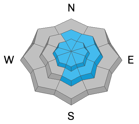
Moderate to strong west to northwest winds accompanying the storm have deposited soft slabs of drifted snow in steep lee terrain. These thick, chalky slabs will be most prominent on north to east to south facing terrain in the upper-elevations, but also lurking to the lee of ridgelines and terrain features in the mid-elevations. Shooting cracks are signs of unstable snow.
Avalanche Problem #2
New Snow
Type
Location
Likelihood
Size
Description
New snow soft slab avalanches 6-10" deep may still be triggered on steep terrain on all aspects of the upper elevations. Time and warming temperatures will heal these storm instabilities during the day today.
Additional Information
A Few Things to Remember:
  • Whether you're-hiking, hunting, skiing, boarding, snowshoeing or firing up the snowmachine: be prepared for avalanches
  • Any avalanche can produce serious trauma because of a thin snowpack
  • Hitting rocks and stumps is a real danger. Don't end your season.
  • Treat ski resorts as backcountry terrain and check out the UAC site for resort uphill travel policies

It's never too early to start thinking about avalanches. A few things to consider:
1. Attend USAW and learn more about avalanches and decision making. (scroll down to the bottom of this page for more info and links)
2. Sign up for an avalanche class.
4. Take the all-new online avalanche courses the UAC built for Know Before You Go or take other online courses listed on the KBYG website (Develop skills -> Online Learning).
5. Get your avalanche rescue gear ready for winter. Put fresh batteries in your transceiver and update the firmware. Inspect your shovel and probe. Get your airbag backpack ready by doing a test deployment and update the firmware if it is an electric version.
Sign up for the 15th Annual Utah Snow and Avalanche Workshop (USAW) one night left, November 9th. Sign up and get more info for the second session HERE.
The Avalanche Professional and Ski Patrol Snow and Avalanche Workshop (PROSAW) will be during the day of November 7th. Sign up and get more info HERE. (note - PROSAW will be offered both in-person and virtual).
General Announcements

This information does not apply to developed ski areas or highways where avalanche control is normally done. This forecast is from the U.S.D.A. Forest Service, which is solely responsible for its content. This forecast describes general avalanche conditions and local variations always occur.