Forecast for the Moab Area Mountains

Dave Garcia
Issued by Dave Garcia for
Tuesday, March 15, 2022
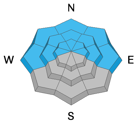
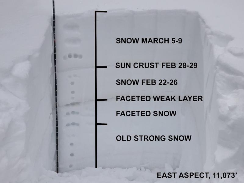
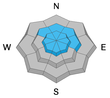
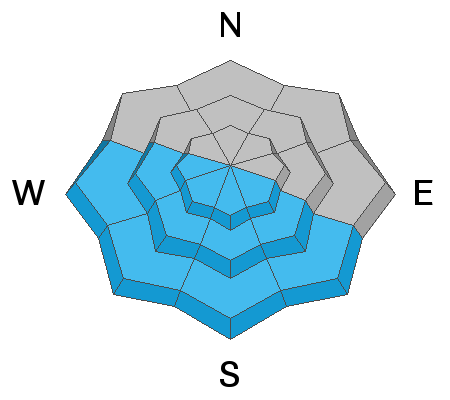
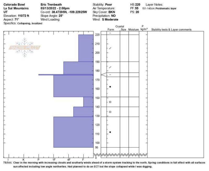
There is a CONSIDERABLE avalanche danger on steep slopes facing NW-N-NE-E and human triggered avalanches failing on a buried persistent weak layer 2-3 feet deep are likely. Keep your terrain choices conservative today. A MODERATE danger for triggering this type of avalanche exists on W facing slopes. Solar aspects will develop a MODERATE danger as the day heats up. Wet loose avalanches will be possible on sunny slopes.
Low
Moderate
Considerable
High
Extreme
Learn how to read the forecast here
Special Announcements
Road Conditions: The road is a mix of dirt, mud, and patches of packed snow. It gets sloppier as the days warm up. All wheel drive and good tires are recommended.
Grooming: Trails have not been groomed since last week but they are well packed from traffic.
Weather and Snow
6:00 a.m. weather data:
24 Hour Snow 0" 72 Hour Snow 1" Base Depth at Gold Basin 60" Wind SW 5-10 Temp 8F
We have another warm sunny day ahead of us with highs in the upper 30's. Winds will remain light out of the SW and blow 5-10 mph. A weak system will move in Wednesday with a chance for maybe 2" of snow. Sunny skies return Thursday and should last into the weekend.
Snowpack
Steadily warming temps and strong March sunshine have done a number on Solar aspects. It's still too soon for a corn cycle and these slopes will start out with crusts today. Look for the southerlies to get sloppy as the day heats up. Sheltered North faces are still your best bet for powder and soft snow. It may feel like spring out there, but the snow pack is behaving like it's the middle of winter. We have a buried persistent weak layer of faceted snow that formed during the Jan-Feb high pressure that is still reactive. An avalanche failing on this layer will be 2-3 feet deep. Check out Eric's video below for an excellent summary of what's going on with the snow pack.
Snow and Weather Links
Gold Basin SNOTEL site (10,000')
Storm Totals in Gold Basin
Wind Station on Pre Laurel Peak (11,700')
Recent Avalanches
It was an active weekend throughout the state for human triggered avalanches with almost all of the other zones reporting accidents and near misses. A lot can be learned from these reports, and it's certainly worth your time to read through them.
Ad
Avalanche Problem #1
Persistent Weak Layer
Type
Location
Likelihood
Size
Description
A persistent weak layer of loose, sugary faceted snow exists on W-N-E aspects beneath a slab that is 2' -3' thick. This problem is most pronounced on slopes facing NW-N-NE-E near treeline and below and the weak layer is easy to locate with your shovel. At the middle and lower elevation bands, backcountry observers continue to report failures in stability tests, collapsing, and shooting cracks. Above treeline the weak layer distribution is much more variable and it is hard to track. Attempting to outsmart this avalanche problem in the alpine is a dangerous proposition. By mid March skiers and riders in the La Sals start to think about big objectives and skiing the high peaks, but now is not the time. There is a reason we call this type of weak layer persistent, and patience is the name of the game for now. Low angle slopes remain your best bet for skiing today.
Read Eric Trenbeath's great observation from Sunday for more insight on this buried PWL.
This image illustrates the snow pack history from when it quit snowing on December 31, through now (Eric Trenbeath). To see how the snow nerds record this information, scroll down to additional information.
Avalanche Problem #2
Wind Drifted Snow
Type
Location
Likelihood
Size
Description
Shifting winds over the past week have blown and drifted snow on to all aspects at upper elevations and there may be a few, unstable wind slabs lurking about. On Southerly aspects these drifts will be stiff and more stubborn to trigger. On northerly aspects, drifted snow has added more weight and stress to the buried persistent weak layer increasing the likelihood for a deeper, more dangerous avalanche. Wind drifts are recognizable by their smooth, rounded appearance and cracking is a sign of instability. Avoid steep wind drifted slopes, especially those facing the north side of the compass.
Avalanche Problem #3
Wet Snow
Type
Location
Likelihood
Size
Description
Wet loose avalanches will become possible on slopes facing W-S-SE today as things heat up. This problem should be easy to manage. These slopes will support your weight this morning. When things are getting too warm the snow will become heavy, wet, and slushy and you will punch through the snow. Roller balls and pinwheels moving down hill are a bulls eye clue that it’s time to leave the sunny slopes.
Additional Information
Eric Trenbeath submitted this snow profile from his tour above Geyser Pass on Sunday. The layer/s of concern are between 130-150 cms.
General Announcements
Who's up for some free avalanche training? Get a refresher, become better prepared for an upcoming avalanche class, or just boost your skills. Go to https://learn.kbyg.org/ and scroll down to Step 2 for a series of interactive online avalanche courses produced by the UAC.
This forecast is from the U.S.D.A. Forest Service, which is solely responsible for its content. This forecast describes general avalanche conditions and local variations always occur.