Fall Auction is now live! Check it out now

Observation: Brighton Perimeter

Observation Date
3/7/2022
Observer Name
B
Region
Salt Lake » Big Cottonwood Canyon » Brighton Perimeter
Location Name or Route
Brighton Periphery: Snake Creek to Catherines Area
Weather
Sky
Broken
Wind Direction
Northwest
Wind Speed
Light
Weather Comments
Patches of sun mixed with S-1 snowfall throughout the day. Cold temperatures. Light WNW winds with very little transport observed.
Snow Characteristics
New Snow Depth
1"
New Snow Density
Low
Snow Surface Conditions
Powder
Wind Crust
Damp
Snow Characteristics Comments
Excellent riding with areas that did not receive wind removed snow during the event the best. There appeared to be NW facing upper elevation terrain that received minimal but enough wind to limit the depths of the new snow and were distinctly thinner riding. E and ENE had more bottom feeding on steep terrain with E having stout m/f crusts under the new snow. ESE and S went off by late morning.
Red Flags
Red Flags
Recent Avalanches
Poor Snowpack Structure
Red Flags Comments
Poor structure continues to be the biggest issue with avalanches being reported on Steep terrain in isolated areas.
Avalanche Problem #1
Problem
Persistent Weak Layer
Trend
Increasing Danger
Problem #1 Comments
Remote and human triggered Persistent Slab Avalanches continue to dribble in via reports from isolated areas. This issue may be becoming a more widespread issue with the addition of any loading over the next 24 to 48 hours with the next strom.
Avalanche Problem #2
Problem
Wind Drifted Snow
Trend
Increasing Danger
Problem #2 Comments
Winds forecast to ramp up
Comments
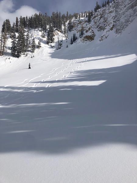
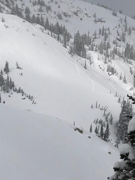
See two photos below. Both photos illustrate questionable route finding. Beyond the fact that personal risk tolerance may allow for persons to put uptracks straight up steep slopes, the fact remains that we have a finite source of skiing terrain in the Wastch Central Core. Photo two from Figure 8 has an uptrack taking out multiple potential ski and riding lines. FYI, the best and safest possible uptrack to ride Figure 8 may be seen in the right side of the photo up the low angle ridge line. The first photo is from Martha's Bowl and the uptrack goes up the steepest part of the bowl directly under the Double Dog Leg entrance into the bowl. It is very easy and safer to put an uptrack on the riders left side of the bowl. Finaly, there was an uptrack going straight up the Dog Lake Chutes...no picture, and this one is very easy to figure out. Obviously no avalanche issues were involved in these choices and it is again a personal risk tolerance choice to travel where ever you want, but it would be great if everyone could consider how their uptracks are effecting our backcountry community and the riding conditions out their.
Today's Observed Danger Rating
Moderate
Tomorrows Estimated Danger Rating
Considerable