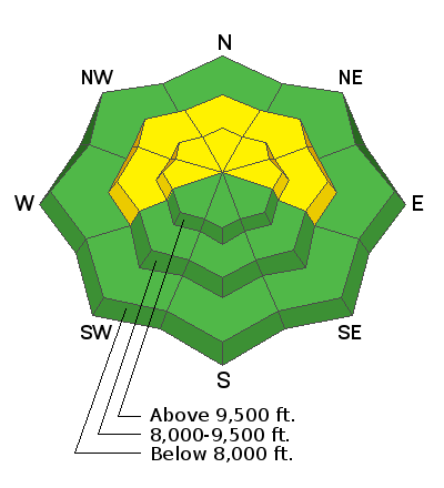
This morning, there are a few clouds in the sky and mountain temperatures are in the low and mid-40s °F. Upper elevation temperatures, near 11,000' have finally dropped below freezing, while some lower elevation trailheads are still sitting near 40 °F. Winds are blowing from the southwest at speeds of 10-20 mph, with the upper elevation ridgelines hitting gusts near 30 mph.
Today, warm southerly to southwesterly flow and moderate winds will accompany the incoming trough, with snow showers kicking off mid-morning. This morning will start mostly cloudy, before snow showers begin and peak around noon. We can expect 2-5" of new snow before the sun sets this evening. There could be periods of rain mixed in with snow. Mountain temperatures will climb into the upper 40s °F. The winds will be from the southwest and blow at speeds of 10-25 mph throughout the day. Upper elevation ridgeline gusts could reach 50 mph.
Overall, this wave today will contribute a very small portion of the storm totals, with the main event still to come Saturday evening through Sunday morning with a much more potent system that will finish with a more favorable west to northwest flow. The question is, how much snow will we get. The NWS is reporting anywhere between 10-16" (0.75 - 1.25") . I suppose only time with tell, this is a complex weather pattern, but what we do know is that avalanche conditions will be rapidly changing as we add more snow.
Backcountry observers reported another round of small wet loose avalanches as the sun heated the southerly terrain. Multiple wet-loose avalanches were reported from lower Little Cottonwood Canyon, near Coalpit that could be seen from the Buttress climbing area.
Be sure to check out all the observations
HERE.
Greg Gagne's Week in Review is published and can be found
HERE.