Join us for the 17th Annual Professional Snow and Avalanche Workshop (PROSAW) on November 4 - Purchase tickets here!

Forecast for the Salt Lake Area Mountains

Trent Meisenheimer
Issued by Trent Meisenheimer on
Tuesday morning, March 1, 2022
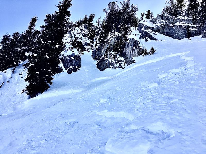
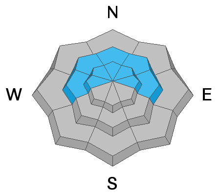
The avalanche danger will rise to MODERATE on mid and upper elevation slopes facing east through south and west, where natural and human-triggered wet-loose avalanches will become possible.
There is a LOW avalanche danger for triggering soft slabs 1' to 2' deep, failing on a buried persistent weak layer on mid and upper elevation steep slopes facing west through north and east. Watch for unstable snow on isolated terrain features.
Low
Moderate
Considerable
High
Extreme
Learn how to read the forecast here
Special Announcements
A Couple of good events this week:
Weather and Snow
Under clear skies, the mountain temperatures range from 25-33 °F. Winds are generally from the west and are currently blowing 5-10 mph across the upper elevation terrain.
For today, expect plenty of sunshine with the possibility of a few high clouds overhead by the afternoon. Mountain temperatures will rise again into the mid to upper 40's °F this afternoon.
The weather looks to change this coming weekend with a series of troughs. Stay tuned.
Recent Avalanches
Yesterday, on sunny slopes, many backcountry observers reported small wet loose avalanches as the March sun, and warming temperatures made the snow weaken and become unstable on steep, sunlit slopes.
On northerly (shady) terrain, another party reported finding multiple shallow soft slabs that failed on our buried persistent weak layer in Millcreek Canyon. These shallow slabs were isolated to steep terrain features and small in size (picture below). Be sure to check out all the observations HERE.
Photo: Grainger, Young, Dromgoole
Ad
Avalanche Problem #1
Wet Snow
Type
Location
Likelihood
Size
Description
Overnight, with clear skies and mountain temperatures dropping below freezing, I would expect the snow surfaces to be frozen on the south half of the compass. Later this morning and into the afternoon, the sun will once again warm the southerly facing terrain, loosening the bonds between the grains as the snow surface becomes damp (diurnal temperature cycle). With enough direct sun and warming temperatures, the snow can lose all its strength and begin to slide down steep terrain naturally.
This avalanche problem is what we call "predictable," meaning - we will see wet loose avalanches again later today. If you're in sunny terrain and the snow surface becomes wet and unsupportable to your weight, it's time to change aspects or head home. Rollerballs/pinwheels are generally the first sign of unstable wet snow. Natural and human-triggered loose wet snow avalanches are possible today.
Avalanche Problem #2
Persistent Weak Layer
Type
Location
Likelihood
Size
Description
The January/February drought resulted in weak, faceted snow along many snow surfaces, and it was covered by roughly 8-16" of snow and wind drifting from the past week.
Avalanches failing on this persistent weak layer have been failing as soft slabs roughly 8-16 inches deep and up to 60 feet wide. These avalanches are confined to isolated terrain features where the slab is slightly stiffer. It also seems the most suspect terrain is the mid to upper elevation sheltered slopes that did not see any wind or sun during our long dry spell, making the surface facets that much weaker, as seen in this observation HERE. Cracking and Collapsing is a bullseye clue to unstable snow and should not be ignored.
Terrain selection will be the great equalizer. There is a big difference between a slope with a clean runout and one that ends in a cliff. Remember that small avalanches in gnarly terrain can have serious consequences.
General Announcements
Who's up for some free avalanche training? Get a refresher, become better prepared for an upcoming avalanche class, or just boost your skills. Go to https://learn.kbyg.org/ and scroll down to Step 2 for a series of interactive online avalanche courses produced by the UAC.
This information does not apply to developed ski areas or highways where avalanche control is normally done. This forecast is from the U.S.D.A. Forest Service, which is solely responsible for its content. This forecast describes general avalanche conditions and local variations always occur.