

Greg Gagne
Forecaster
Our Week in Review highlights significant snowfall, weather, and avalanche events of the prior week. (Review the archived forecasts for the Salt Lake mountains.)
The danger roses for the Salt Lake mountains from Friday, January 7 through Thursday, January 13:
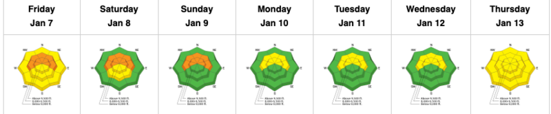
Summary: A small storm overnight Friday into Saturday, followed by high pressure through the end of the week.
Friday, January 7: Increasingly cloudy skies with snowfall overnight into Saturday with 2-4" new snow by Saturday morning. The only backcountry avalanche reported is a small wind slab from The Cone along the Big Cottonwood/Millcreek Ridgeline

Saturday, January 8 - Wednesday, 12: Clearing skies on Saturday lead into an extended period of high pressure. No backcountry avalanches are reported. Control work from some Cottonwood and Park City resorts continue to pull out avalanches on mid and upper elevation northerly slopes failing in faceted snow down near the ground, but fewer avalanches from control work are being reported, and the UAC moves from a Considerable avalanche danger where the PWL is present to Moderate.
Thursday, January 13: Very warm temperatures for early January, reaching into the upper 30's and 40's. No backcoutnry avalanches reported.


