Join us at our 2nd Annual Blizzard Ball

Forecast for the Moab Area Mountains

Eric Trenbeath
Issued by Eric Trenbeath on
Saturday morning, December 11, 2021
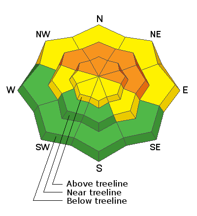
Heavy snowfall combined with wind has created dangerous avalanche conditions. The danger is CONSIDERABLE on steep, mid to upper elevation terrain that faces NW through E and human triggered avalanches are likely. In these areas, new and wind drifted snow has formed a dense, cohesive slab on top of weak, sugary, faceted snow creating an unstable situation. The avalanche danger is MODERATE on low elevation, northerly facing slopes, and on terrain wrapping around to the south side of the compass where you can detect recent deposits of wind drifted snow. Coverage remains quite thin and a ride in an avalanche would be brutal in these shallow snow conditions. Enjoy the fresh snow and beautiful sunny day but beware of lingering obstacles below the surface and keep your stoke reigned in!
Low
Moderate
Considerable
High
Extreme
Learn how to read the forecast here
Special Announcements
Road Conditions: Grand County plowed the road yesterday but it is a bit soft and narrow. All wheel drive and good tires required.
Grooming: Equipment is on site and trail grooming will begin soon!
Batteries for Beacons runs through Dec 19. Get free batteries for your transceiver and a chance to win 1 of 10 Black Diamond Rescue Kits, 1 of 3 Mammut Barryvox transceivers, or 1 of 3 BCA Tracker transceivers. Stop in at Moab Gear Trader, fill out our survey and get a free set of batteries. Don't need batteries, but still want a chance to win? Simply fill out the survey to be registered.
I was recently interviewed by Peggy Hodgkins for Science Moab. You can listen to the podcast: The Art of Avalanche Forecasting here.
Weather and Snow
24 Hour Snow 0" 72 Hour Snow 19" Base Depth in Gold Basin 31" Wind WSW 10-20 Temp 0F
Skies are mostly clear, winds have backed off and swung around to the WSW, and it's cold up there! Today will be a beautiful winter day in the mountains with sunshine, fresh snow, and high temps in the low to mid 20's. Sunday will see continued sunny skies, slightly warming temperatures, and increasing SW winds. Southwest flow develops Monday into Tuesday ahead of the next storm system to affect our area. Details aren't ironed out yet but it's holding promise.
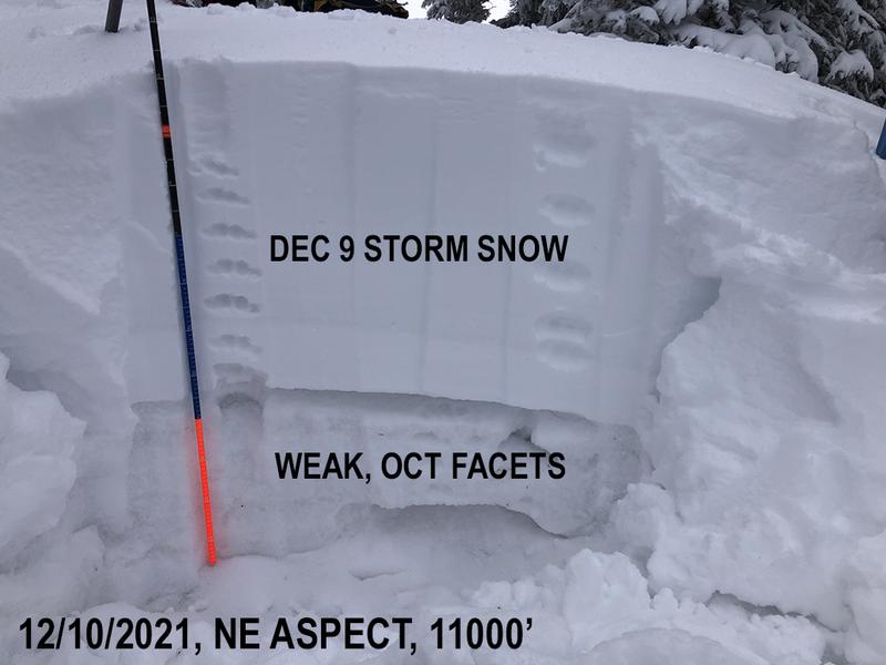
Thursday's storm delivered 19" of dense snow to the mountains. In our travels yesterday we observed sensitive conditions with fairly widespread collapsing on shady, northerly facing terrain that had pre-existing, weak and sugary snow on the ground from October. The snow density and "right side up" nature made travel fairly easy, and turning is possible on lower angle terrain. It's also dense enough to keep you up off the ground so grassy, low angle terrain is the place to be.
Weather Links
BRAND NEW! Gold Basin SNOTEL site (10,000')
Recent Avalanches
In our travels yesterday we observed several natural avalanches on steep, northeasterly facing terrain in upper Brumley Creek. These slides were between 100' and 200' wide, and about 2' deep involving all of the new snow and likely failing on the weak faceted snow underneath.
Ad
Avalanche Problem #1
Persistent Weak Layer
Type
Location
Likelihood
Size
Description
And so it begins. Snow that has been sitting around on the ground since October has become weak and faceted and a slab up to 2' thick is sitting on top. This condition exists on slopes facing NW through E and it will likely pose a persistent weak layer problem for the foreseeable future. For now, human triggered avalanches failing on this weak layer are likely, and steep, northerly facing terrain should be avoided.
Avalanche Problem #2
Wind Drifted Snow
Type
Location
Likelihood
Size
Description
Blowing and drifting snow throughout the storm has created dangerous drifts up to 2' deep or more on leeward, northerly facing slopes at mid and upper elevations. As winds shifted to the NW, some snow was transported on to more southerly aspects, particularly at upper elevations. Avoid steep slopes that have recent deposits of wind drifted snow and look for signs of instability such as cracking in the snow surface.
General Announcements
This forecast is from the U.S. Forest Service, which is solely responsible for its content. This forecast describes general avalanche conditions and local variations always occur.