
Greg Gagne
Forecaster
Our Week in Review highlights significant snowfall, weather, and avalanche events of the previous week. (Review the archived forecasts for the Salt Lake mountains.)
The danger roses for the Salt Lake mountains from Friday, March 26 through Thursday, April 1:
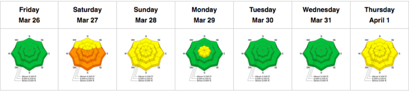
Summary: Light snowfall and colder temperatures early in the period, with gradually warming temperatures and wet avalanche activity. The UDOT avalanche forecasting operation in Little Cottonwood reports March snow/water totals of 53" snow containing 4.15" of water. (March averages 86" with 7.90" water.)
Friday, March 26: Cloudy skies and light snowfall. Snow totals since Thursday are 2-4", with the highest amounts in Little Cottonwood Canyon. The only avalanche activity reported in the Salt Lake mountains was minor sluffing in the storm snow, however, further south in the Provo mountains, a 6" deep/2'' wide wet slab is reported near Elk Point on Mt. Timpanogos.
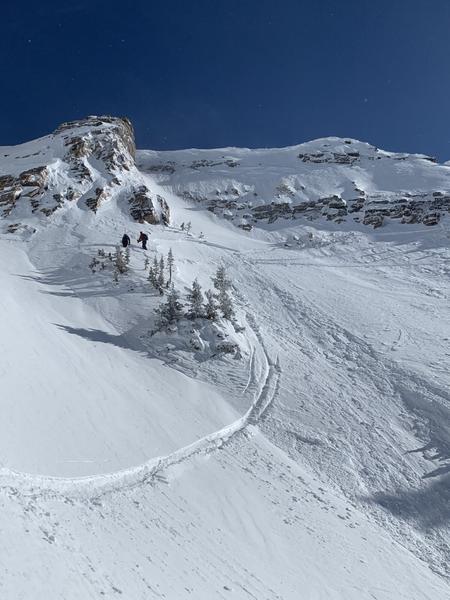
Saturday, March 27: Despite the strong sunshine, cool temperatures and a light breeze kept the snow surface generally cool with wet-loose avalanche activity is reported. There was one-human-triggered slide on a south-facing slope at 11,000' on Twin Peaks where a skier was caught in a small avalanche involving wind-drifted snow. The slide was shallow (8" and 30' wide) and the rider was able to self-arrest after being carried for 50'.
Sunday, March 28: Clear skies and warm temperatures with additional wet-loose natural avalanche activity reported.
Monday, March 29:After two days of warm temperatures, cloudy skies, and stronger winds - with gusts nearing 80 mph at 11,000' - ahead of a dry cold front that moves into the region. Light snow showers with only a trace of new snow. No backcountry avalanches are reported.
Tuesday, March 30: Clear skies and cold temperatures lock up the frozen snow surface. No backcountry avalanches are reported.
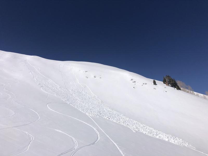
Wednesday, March 31: Clear skies with temperatures increasing slightly. The only backcountry avalanche reported is a skier-triggered, wet-loose avalanche on Mt. Raymond that was 6" deep and 25' wide, with a debris pile of up to 3'.
Thursday, April 1: Sunshine and clear skies, with temperatures reaching the mid to upper 40's F. at low and mid elevations, with above freezing at 11,000'. Minor wet, loose avalanching reported. The only notable event was a collapse on a southeast aspect just below 10,000' on the Emma Ridges. The slab was a melt-freeze crust 10 cms (4") thick sitting on top of dry snow underneath. The collapse and fracture propagated up to 50' and was a good heads-up of the potential for wet slab avalanches over the upcoming weekend of very warm temperatures and strong sunshine.


