Chris Benson
- The first half of February is off to an active start for the southern Utah Mountains.
- Consistent, but mostly small storm totals have graced the mountains with much needed snow.
- Here is a snapshot of the regional snowpack as of Feb. 18th, 2021:
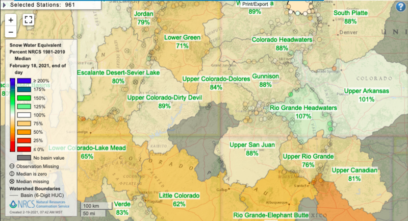
https://www.nrcs.usda.gov/wps/portal/wcc/home/quickLinks/imap
- Over the last two weeks, several storms embedded within NW flow have deposited around 1.5" of SWE, translating to about 10-20" of snow in the high country.
- Additionally, a storm with SW flow resulted in the single largest loading event of the season thus far, on 2/13/2021, with 1.5" of SWE and up to 20" of snow at higher elevations. This resulted in high avalanche danger as well as an avalanche warning for the La Sal and Abajo Mountains on Sunday February 14, 2021.
- This precipitation coupled with moderate southerly winds produced a surprisingly modest avalanche cycle, with reports of only 3, medium-sized avalanches on northerly aspects, near and above treeline. One explanation for this could be that some avalanche paths ran during the storm, only to be covered by the continued snowfall.
- One medium-sized avalanche was reported from the Abajos on an east aspect as well.
- A sneaky-storm spanning 2/16-2/17/2021 left another 0.5" of SWE and up to 10" of low-density snow at upper elevations with little to no wind associated with this storm.
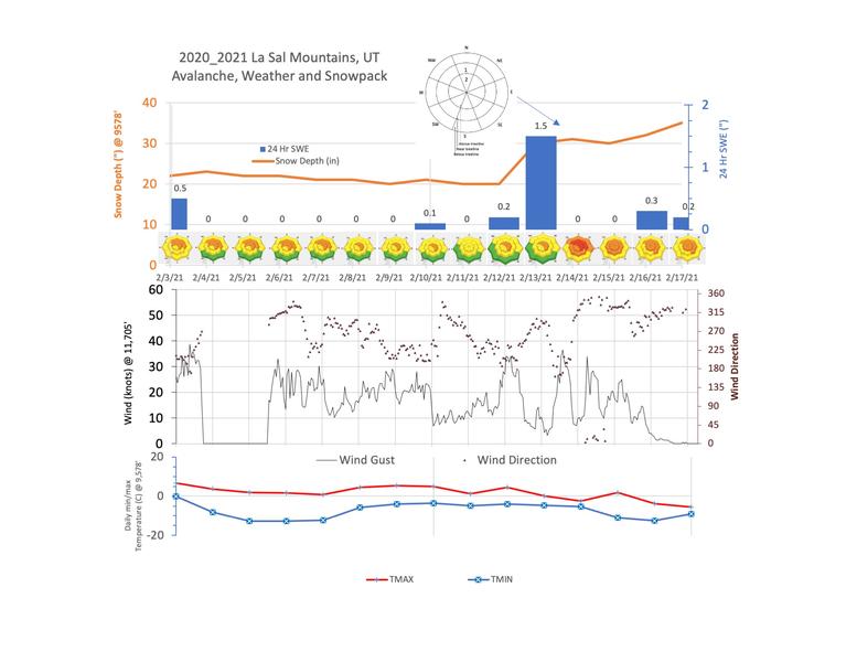
- What to look for in the snowpack: the weak layers that formed in December and early January are now buried even deeper under a 1-3' thick slab of cohesive snow on a variety of aspects. You can notice them by their relative softness, large-grain sizes, and greyish color. Snowpack tests and regional avalanche activity continue to suggest that this poor snowpack structure will produce large and destructive avalanches.