March Kicks Off Our Spring Campaign- Donate Now to Support Forecasting

Forecast for the Uintas Area Mountains

Mark Staples
Issued by Mark Staples on
Friday morning, February 12, 2021
HEADS UP - The danger will be rising through the weekend and into next week
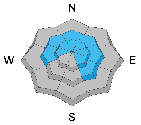
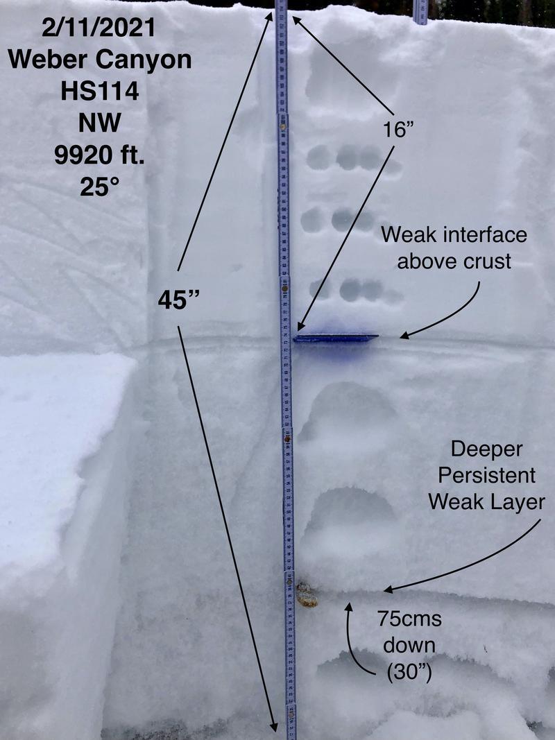
The dangerous snowpack structure hasn't gone away. With a few inches of new snow and some wind, the avalanche danger above treeline is CONSIDERABLE on northerly facing slopes as well as east and southeast facing ones. Avalanches can be 2-4 feet deep and hundreds of feet wide. Human triggered avalanches are LIKELY on these slopes.

Near treeline in mid elevation terrain, human triggered avalanches are possible and the avalanche danger is MODERATE.
There's less snow and less of a slab below treeline where the danger for today is LOW. Watch out - the danger on these slopes should increase this weekend if we get heavy snowfall.
Low
Moderate
Considerable
High
Extreme
Learn how to read the forecast here
Avalanche Watch
FOR ALL THE MOUNTAINS OF NORTHERN UTAH INCLUDING THE WASATCH RANGE...BEAR RIVER RANGE...UINTA MOUNTAINS...MANTI SKYLINE
THE AVALANCHE DANGER WILL RISE TO HIGH BY SATURDAY, AND VERY DANGEROUS AVALANCHE CONDITIONS ARE LIKELY TO CONTINUE THROUGH THE HOLIDAY WEEKEND.
HEAVY SNOW AND DRIFTING WILL OVERLOAD BURIED PERSISTENT WEAK LAYERS AND CREATE WIDESPREAD AREAS OF UNSTABLE SNOW. BOTH HUMAN TRIGGERED AND NATURAL AVALANCHES WILL BECOME LIKELY. STAY OFF OF AND OUT FROM UNDER SLOPES STEEPER THAN 30 DEGREES.
Special Announcements
The final report about an avalanche that killed four people last Saturday in upper Mill Creek Canyon in the central Wasatch Mountains is available HERE. Our deepest condolences go out to the friends and families involved.
Weather and Snow
Nowcast-
Snow is starting to fall this morning with about an inch or two of new snow as of 6 a.m. Temperatures are generally hovering near 20 degrees F. Winds at upper elevations are blowing from the SW at 25 mph with gusts of 30-40 mph. At lower elevations, winds are blowing 10-15 mph.
Forecast-
3-5 inches of snow should fall today. Some cold air will descend over the area today and keep temperatures from warming. Winds will shift and blow from the west and maybe ease just a little this afternoon.
Futurecast-
More snowfall is on its way. Snowfall should taper off tonight and then return on Saturday possibly dropping a foot of snow by Sunday morning. It will taper off Sunday and return on Monday. Weather models show more storms coming especially near the end of next week.

Looking for real-time temps, snow, or wind?
Click here and then on the "western Uinta" tab for western Uinta specific, weather station network.
Recent Avalanches
Local avalanche pros continue to trigger slides which lets us know that the problems haven't gone away. Below is an example of one of these slides.
Many large avalanches were triggered across the range this weekend including a near miss at Moffit Peak with an amazing viddy HERE.
Recent avalanche activity is found HERE.

More obs and trip reports found here.
Ad
Avalanche Problem #1
Persistent Weak Layer
Type
Location
Likelihood
Size
Description
The snowpack has a weak foundation of persistent weak layers of facets or sugar covered by a hard slab of snow that will be growing in size as more snow is added on top. Many avalanches happened last weekend and more will occur. More snow today and this weekend will add more weight and stress to the snowpack and make conditions become steadily more dangerous through the weekend.
The good news is that the snowpack is slowly getting deeper and approaching 4 feet deep in places. The bad news is that this means avalanches are getting larger and more deadly. There are two main weak layers (1) one is in snow from late November/early December near the ground, and (2) the other is in the middle of the snowpack from a dry period in mid January. In places with a thinner snowpack, these weak layers have merged and it's hard to distinguish them. JG's snowpit below shows these two weak layers well.
THIS AVALANCHE PROBLEM IS TRICKY - Tracks on a slope do not mean it's safe. As the slab on top of the snowpack gets thicker and stronger, it allows us to get well out onto the slope before it fails and it may be the 2nd, 3rd, or even 10th person on a slope who triggers the slide.
Avalanche Problem #2
Wind Drifted Snow
Type
Location
Likelihood
Size
Description
Moderate winds and a few inches of snow means that you will find some shallow slabs of recently wind drifted snow. By themselves they shouldn't be a major concern. The problem is that they will add extra load and stress to buried persistent weak layers which increases the likelihood of triggering a large, destructive slide.
Additional Information
Last week, Andy, Joey, and I setup the avalanche beacon training park at the Nobletts trailhead. There is also one at the Bear River Trailhead that Ted Scroggin set up. These beacon parks have pre-buried beacons that you can turn on/off with a control panel. It only takes a few minutes to refresh your beacon searching skills at one of these places.
I will update this forecast by 7:00 AM tomorrow, Saturday, February 13th.
Your observations are import, so please let me know what you're seeing... click HERE and contribute to this amazing community based program
General Announcements
If you see or trigger an avalanche or just wanna let me know what you're seeing you can reach me directly at 801-231-2170 or [email protected]
This forecast is from the U.S.D.A. Forest Service, which is solely responsible for its content. This forecast describes general avalanche conditions and local variations always occur.