Chris Benson
Building a house of cards…
Fall and early winter of the 2020-2021 season has been marked by several relatively small early season storms. Drought persists with the snowpack in the La Sals at 19% of median as of 12/23/2020. Currently, there is 0.8” of snow water equivalent (SWE) at the SNOWTEL site. While this site sits at a relativity low elevation, it does provide a good record of snowfall events and temperature trends.
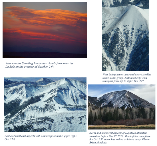
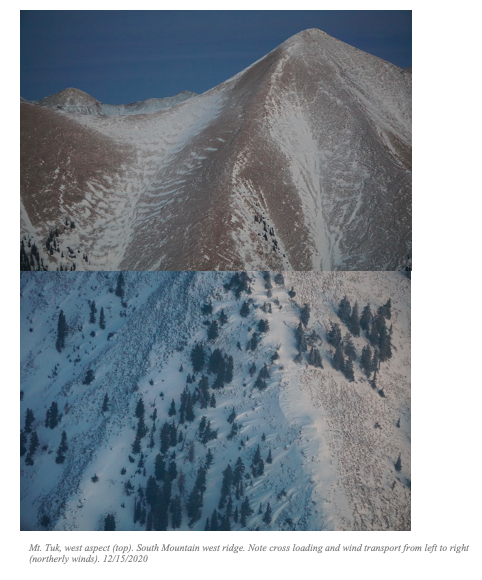
The first storm occurred on October 25th and deposited around 1” of SWE equating to 7” of snow at the La Sal Mtn SNOWTEL site (9,578’ elevation). Observations from Oct. 27th revealed variable snow coverage, with wind transport from the North. The pre-Laurel Peak weather station recorded NW to NNW winds with gusts in the 50-mph range, both during the storm and immediately afterwards.
From 10/28/2020 to 11/7/2020, nighttime temperatures barely froze, and daytime highs were 10-12 ºC. This warm period melted snow at 9,500', and at higher elevations on sunny aspects. In more sheltered areas, these warm temperatures likely produced both “temperature crusts” as well as sun crusts in areas that experience direct sunlight. Mostly calm and clear conditions prevailed until 11/7/2020.
The next system (11/7/2020) added another 1” of SWE incrementally over 3 days. This snow fell on bare ground in many places where older snow had melted from a warm early November. In north-facing or shady areas, this snow may have fallen on older snow. Wind patterns from Nov. 7-9 were fairly consistent; out of the south southeast at 20 mph, gusting to the 40-mph range. No avalanches were reported in the La Sal Mountains or nearby Abajo Mountains during this time.
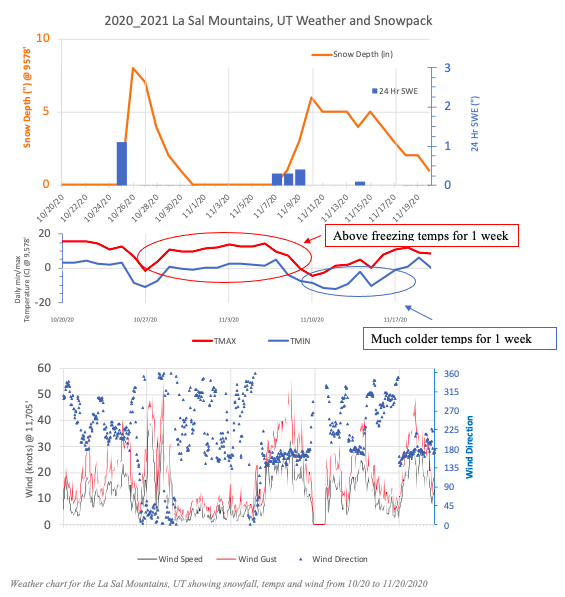
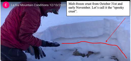
Following the November 7, 2020 storm cycle, low temperatures dropped between -7 to -12 ºC. This created a strong temperature gradient in the snowpack, leading to the formation of facets on shady aspects near and above treeline. The critical temperature gradient (change of temperature across snow depth) for the formation of facets is around 1 ºC per 10 cm (the ground stays close to 0 ºC all winter). With a shallow snowpack averaging 10-40 cm around the range, these cold temperatures likely produced temperature gradients of 10 to 2.5 ºC per 10 cm, leading to the rapid development of facets near the ground as well at the surface of the snow. Some of these facets may have formed on top of the crust from warm temperatures occurring the week after Halloween. This “Spooky Crust”, and potential crust-facet combo situation is particularly undesirable because now we have facets on top of a slippery bed surface (crust).
The next storm arrived on November 14th, 2020 adding a paltry 0.1” of SWE, with reports of a trace of snow around the mountains. Initially, southerly winds battered the alpine and transported what little snow was present to north-facing aspects. Temperatures warmed for several days, with above-freezing nighttime low temps from the 17th-22nd.
The next few weeks were relatively quiet, with a dusting on the 25th. Daytime high temperatures were above freezing almost every day at 9,500'. Nighttime low temps. hovered around -8 ºC. Again, with a shallow snowpack, these low temps lead to the formation of facets. Winds were mostly unremarkable during this time.
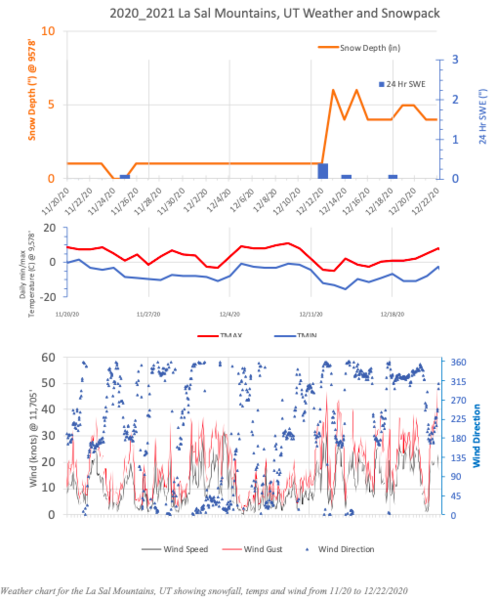
On December 12th, and moderate storm clipped the Sierra La Sal bringing 0.4” of SWE. Storm totals ranged from 6" of snow at the Geyser Pass trailhead to an estimated 8"-10" in Gold Basin. This is the same system that dropped much more snow in Colorado and created unstable conditions that unfortunately set the stage for three fatalities on 12/18 and 12/19/2020. Ridge top winds during the storm blew in the 20-30 mph range from the SW before backing off and shifting to more northerly directions. As the front passed and into December 15th, winds increased from the north and blew in the gusted into the 30-40 mph range.
A light dusting of snow occurred on the 18th, and observations from a party touring in Gold Basin reported a good amount of cracking in the new snow on specific terrain features.
Up until this point, no avalanches were observed in either the La Sal or Abajo Mountains. This changed on December 22nd, when a soft slab was remotely triggered by a skier near North Pass, on a north aspect at 11,000’.

Recent events in Colorado highlight the weak structure of this year’s snowpack. While not an uncommon situation for this part of the world, these conditions warrant caution. In southern Utah, we are only missing a slab on top of this persistent weak layer and pesky crust-facet combo. With snow in the forecast for early next week, this poor snowpack structure will likely become unstable and unpredictable for weeks to come.
Chris, awesome seasonal history write up thus far. Hoping that 19% SWE year to date starts rapidly increasing. Thanks!
Tim Matthews (not verified)
Fri, 12/25/2020


