Join us at our 2nd Annual Blizzard Ball

Forecast for the Salt Lake Area Mountains

Trent Meisenheimer
Issued by Trent Meisenheimer on
Wednesday morning, December 16, 2020
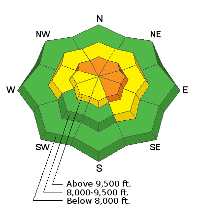
The avalanche danger is CONSIDERABLE on steep slopes that face northwest through southeast at the upper elevations. A MODERATE danger exists on the other aspects up high and on many aspects in the mid-elevations. Approach any steep wind drifted slope with great caution.
Human triggered avalanches 12-18"+ deep are likely and may be triggered at a distance. Careful snowpack evaluation, cautious route-finding, and conservative decision-making are essential today.
Low
Moderate
Considerable
High
Extreme
Learn how to read the forecast here
Special Announcements
Supreme area of Alta Ski Area is now closed to uphill/downhill travel. The summer road to Catherine's Pass will remain open.
Weather and Snow
Under mostly cloudy skies, the northwesterly flow will try and squeeze the last remaining moisture from the atmosphere, with some lingering snow showers lasting into the early afternoon. Current mountain temperatures are in the mid-teens °F at all elevations. Northwesterly winds picked around 5 pm yesterday and are currently blowing 10-15 mph gusting to 25 mph across most upper elevation ridgelines. 11,000' winds are blowing 45-50 mph, gusting into the 60's from the west-northwest.
We have a wet storm on the doorstep that should arrive tomorrow morning lasting through Friday. Ahead of the trough, the temperature warms up, and the winds will back to the southwest as the initial surge of moisture hits northern Utah. Once the trough passes through northern Utah, winds veer back to the northwest, and temperatures cool. It looks like we can expect 8-14" of new snow that contains 0.50-1.0" of water.
Recent Avalanches
Since Sunday, we've had five human triggered avalanches with one catch and carry reported to the UAC (list below). Many, if not all, backcountry observers are reporting widespread cracking and collapsing of the snowpack. Extended column tests continue to show full propagation just under our 8-12" of low-density new snow that fell on the 13th of December. These are all obvious clues to an unstable snowpack.
  • Sunset Peak: Northwest facing slope at 10,500'. The avalanche was 12" deep 35' wide. Catch and carry
  • Twin Lakes Pass: Northeast facing slope at 10,200'. The avalanche was 20" deep 20' wide. Remotely triggered (from a distance)
  • Cardiff Fork: North facing slope at 9,100'. The avalanche was 12" deep 40' wide. Remotely triggered
  • Rocky Point: Northeast facing slope at 10,000'. The avalanches were 12-16" deep and 60' wide. Human Triggered
Ad
Avalanche Problem #1
Persistent Weak Layer
Type
Location
Likelihood
Size
Description
Our mountains are plagued with weak faceted snow, and if you look just to the left, you will see our locator rose. Everywhere on that rose that is shaded blue is where this avalanche problem exists. We have a weak layer, and on the 13th of December, we started building our slab when new snow fell on top of this fragile faceted snow.
Our weak layer is now buried roughly 8-14" deep in many locations, and we see avalanches where the wind drifted the snow just enough to create the slightest increase in density, and now we can trigger the avalanche. The truth is, we have a poor snowpack structure, and slopes greater than 30° degrees in steepness should not be trusted.
My advice is to make conservative terrain choices and keep the slope angle under 30° degrees in steepness with nothing steep above or adjacent to you. Remember, when dealing with faceted snow, we can trigger the avalanche from a distance.
Avalanche Problem #2
Wind Drifted Snow
Type
Location
Likelihood
Size
Description
Overnight the northwesterly winds blew 10-15 mph gusting to 25 mph, and with plenty of new snow available for transport, I would expect some new wind drifts across the upper elevation terrain. On slopes that harbor weak faceted snow, this wind will make the avalanches deeper and more likely to be triggered. As always, avoid steep slopes that are wind loaded. Usually, we can see where the wind blew the snow as it looks rounded, textured, wavey, or pillowy.
General Announcements
Please visit this website with information about Responsible Winter Recreation by the Utah Office of Outdoor Recreation.

This information does not apply to developed ski areas or highways where avalanche control is normally done. This forecast is from the U.S.D.A. Forest Service, which is solely responsible for its content. This forecast describes general avalanche conditions and local variations always occur.