Join us at our 2nd Annual Blizzard Ball

Forecast for the Salt Lake Area Mountains

Drew Hardesty
Issued by Drew Hardesty on
Tuesday morning, December 15, 2020
Approach any steep wind drifted slope with great caution.
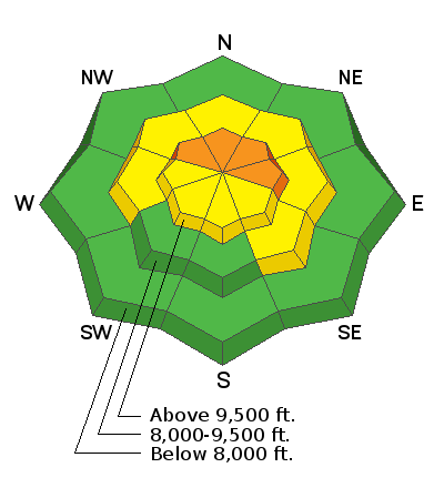
Areas of CONSIDERABLE danger exist on many slopes in the upper elevations. This danger is most pronounced on steep northwest to north to east facing slopes. A MODERATE danger exists on the other aspects up high and on many aspects in the mid-elevations.
Human triggered avalanches 12-18"+ deep are likely and may be triggered at a distance. They may also be triggered from below. Collapsing and cracking are immediate signs of an unstable snowpack.
Please make conservative decisions to avoid getting hurt and further stressing emergency services and the health care system.
Low
Moderate
Considerable
High
Extreme
Learn how to read the forecast here
Special Announcements
Did you know that the UAC hosts a podcast? We're kicking of Season 4 with a conversation with American Avalanche Institute's Sarah Carpenter. You can stream it off our Blog page here....or anywhere you get your favorite podcasts.

Up early? We record a Dawn Patrol hotline usually by 6am each morning. 888-999-4019 option 6.
Weather and Snow
If you're headed into the mountains now, you may still see a few straggler snowflakes catching up to the departing "storm".
Storm totals are roughly 4-8" in the central Wasatch with a density of 5%. Mountain temps are in the single digits; winds are light from the northwest.
For today, clouds should start to thin as the day wears on. Winds will increase out of the west northwest tonight as a weak system passes to the north of us, but the energy and light snowfall should be mostly confined to the Logan area mountains and along the Idaho border. The next Pacific storm arrives Thursday into Friday. Early optimistic totals might be 8-14"...but let's see how the weather models come into focus over the next 12-24 hours.
Recent Avalanches
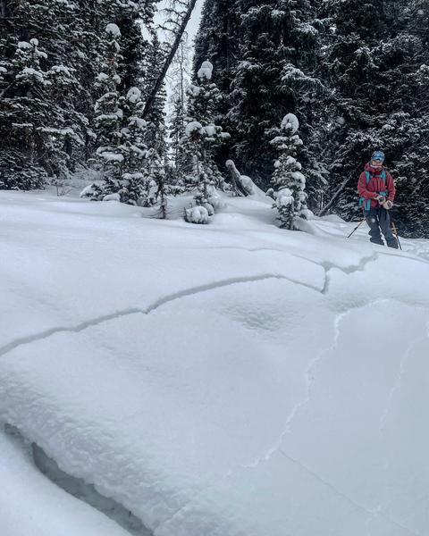
Cracking and collapsing are the rule and not the exception. Nearly every report that came in yesterday included multiple collapses with some long extended shooting cracks. (pc: Mark White)
Without question, the snowpack is on edge. I'll second that.
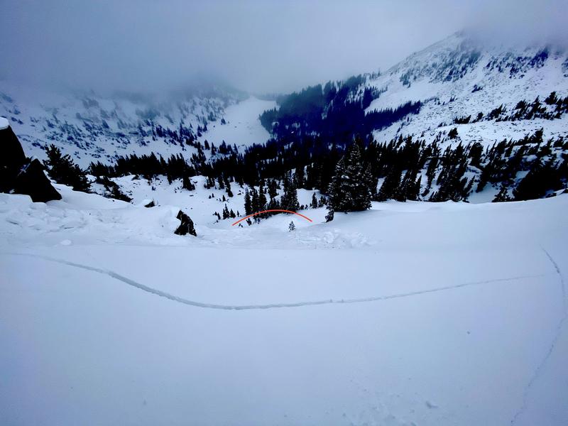
Ski area control teams reported remotely triggering a few soft slabs in unskied terrain, likely very similar to one triggered by Inspired Summit Adventure guides from the safety of the ridgeline above Twin Lakes pass. This was 20"deep and 20' wide, running 300' down the slope. This slide was on a steep northeast facing slope at 10,200'. (pic W. Deutschlander)
Ad
Avalanche Problem #1
Persistent Weak Layer
Type
Location
Likelihood
Size
Description
Many steep slopes remain suspect and one can still trigger an avalanche on - or on approach to - recently wind drifted slopes holding older sugary faceted grains. While a slab exists now in part due to the recent winds, in general it lacks great structure and connectivity currently to break out wider than - say 100' or so. Thursday's storm may provide that.
Still, the current snow structure and avalanche type will allow you to tiptoe into steep terrain and then release well above you. This is what makes these avalanches unmanageable and why yesterday very experienced skiers and guides agreed that safe "available terrain has narrowed significantly in the last 48hours".
Guide/educator Cody Hughes's take on the snowpack below.
Problem: Nearly all aspects and elevations held very weak faceted sugar snow before the storm. The dangerous slopes will be the ones where winds have drifted snow into a cohesive slab. Unfortunately, many of the tell-tale signs of drifts (rounded, chalky, etc) will be covered and hidden by the new low density snow.
Solution: Slope angle is the key. Stay off of and out from underneath slopes 35° and steeper. See UAC forecaster Toby Weed's video below.

Polemic on Wind
Winds drift snow with little equity in regards to distribution on both a macro and micro scale. Southwest winds (from Sunday night) often favor northwest to east facing slopes...but drifts can often be found on nearly any aspect due to terrain channelling. Beyond that, winds from this direction typically pummel areas on the south side of Little Cottonwood Canyon (Maybird, Red and White Pine, etc), upper Big Cottonwood and the south end of the Park City ridgeline. More wind=more danger.
Avalanche Problem #2
New Snow
Type
Location
Likelihood
Size
Description
Sluffing in the steepest terrain is possible today in the recent low density snow. These occur independent of aspect and may be enough to either gouge down into the older weak faceted snow or potentially trigger a fresh wind drift.
Additional Information
General Announcements
Please visit this website with information about Responsible Winter Recreation by the Utah Office of Outdoor Recreation.

This information does not apply to developed ski areas or highways where avalanche control is normally done. This forecast is from the U.S.D.A. Forest Service, which is solely responsible for its content. This forecast describes general avalanche conditions and local variations always occur.