March Kicks Off Our Spring Campaign- Donate Now to Support Forecasting

Forecast for the Uintas Area Mountains

Craig Gordon
Issued by Craig Gordon on
Wednesday morning, November 18, 2020
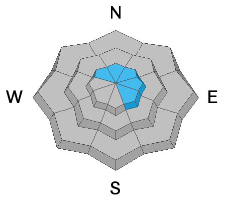
In the wind zone, at and above treeline, you'll find pockets of MODERATE avalanche danger. Human triggered avalanches are possible, especially on steep, wind drifted slopes facing the north half of the compass. Remember... even a small avalanche can easily result in a season ending, traumatic injury.
LOW avalanche danger is found on low angle, wind sheltered terrain.
Low
Moderate
Considerable
High
Extreme
Learn how to read the forecast here
Special Announcements
Looking for ways to navigate the winter ?
Please visit this website with information about Responsible Winter Recreation by the Utah Office of Outdoor Recreation
Weather and Snow
Nowcast-
Southerly winds began ramping up right around sunset and have cranked into the 50's and 60's overnight. Temperatures are mild with overnight lows right around freezing.
Forecast-
A cold front slides through the region later today, bringing with it scattered snow showers and cooler temperatures. Winds decrease this afternoon.
Futurecast-
Weak storms slide through the region throughout the week, but nothing substantial is on the horizon.
Looking for real-time temps, snow, or wind?
Click here and then on the "western Uinta" tab for western Uinta specific, weather station network.
Recent Avalanches
No new avalanche activity to report, but there's just enough snow to ride and of course, enough snow to slide. And remember- even a small avalanche this time of year will instantly end your season if you slam into a rock, or stump, or get raked through deadfall. But that doesn't mean you can't ride, you just need to tone it down a few notches. As a matter of fact, you can still have a blast on lower angle terrain.
To view trip reports and recent avalanche activity, simply click here.
Ad
Avalanche Problem #1
Wind Drifted Snow
Type
Location
Likelihood
Size
Description
Ted was out on Mirror Lake Highway yesterday and captured the image above illustrating strong ridgetop winds drifting snow on leeward slopes. While recent winds coupled with very warm temperatures have worked the surface snow and essentially welded it in place, there may be a stiff drift or two that'll react to our additional weight. For today, you'll want to continue looking for and avoiding any fat, rounded piece of snow, especially if it sounds hollow like a drum.
Additional Information
I'll update this information as conditions warrant and the snowpack develops. Once we get rolling and winter gets going in earnest, you can expect detailed daily avalanche advisories updated by 7:00 AM.
Your observations are import, so please let me know what you're seeing... click HERE and contribute to this amazing community based program
Information on outdoor recreation - The State of Utah created this webpage with information about recreating on both state and federal public lands during the current health crisis.

Skiing and riding at closed ski resorts - Some resorts allow access now, and some do not. Please check HERE for the latest info on ski area access.

New to the backcountry (including riding at closed resorts) - Watch the award-winning, 15 minute Know Before You Go video, or take the 5-part, free online-learning series.
General Announcements
If you see or trigger an avalanche or just wanna let me know what you're seeing you can reach me directly at 801-231-2170 or [email protected]
The information in this forecast is from the US Forest Service which is solely responsible for its content.