March Kicks Off Our Spring Campaign- Donate Now to Support Forecasting

Forecast for the Uintas Area Mountains

Craig Gordon
Issued by Craig Gordon on
Monday morning, November 16, 2020
In the wind zone, at and above treeline, you'll find MODERATE avalanche danger. Human triggered avalanches are possible, especially on steep, wind drifted slopes facing the north half of the compass. Heads up- recent strong winds may have formed fresh drifts around terrain features like chutes or gullies, or even lower downslope than you might expect and remember... even a small avalanche can easily result in a season ending, traumatic injury.
LOW avalanche danger is found on low angle, wind sheltered terrain.
Low
Moderate
Considerable
High
Extreme
Learn how to read the forecast here
Special Announcements
Huge thanks and a big shout out to two leaders in the industry... (nope I'm not talking about Mark and I :)
More importantly- for the past 15 seasons, Tri-City Performance and Polaris have provided loaner sleds to the UAC and this year was no different. This partnership enables us to perform our field days, get into the same kind of terrain and see the same type of snow our customers are riding, and continue delivering the high caliber forecasts you've come to expect from the Avalanche Center. Bottom line... this partnership helps save lives and for that we are grateful!
Weather and Snow
Nowcast-
The big weekend storm is now in Kansas, but it was good while it camped out in the land of Zion, delivering up to 18" of snow in our high country. Warm, high pressure strengthens over the region today and current temperatures reflect this trend. As a matter of fact, most remote weather stations register in the mid to upper 30's, about 10 degrees warmer than at this time yesterday morning. Along the high ridges, west and southwest winds blow in the 20's and 30's. With total snow depths hovering right around two feet, there's just enough snow to move around on, however it's still pretty boney out there.
Futurecast-
It'll be sunny and hot today with highs nearing 50 degrees. This warming trend is accompanied by increasing southwest winds on Tuesday into Tuesday night ahead of a trough which brings gradual cooling, continued strong winds, and a few flakes for Wednesday. An active pattern remains on tap for the end of the work week with the potential for a decent storm by the weekend.
Looking for real-time temps, snow, or wind?
Click here and then on the "western Uinta" tab for western Uinta specific, weather station network.
Recent Avalanches
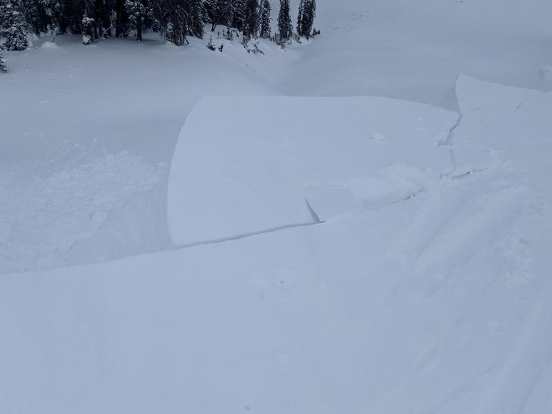
Michael J stomped around yesterday and was able to get the fat, wind loaded pocket in the image above to crack out under his additional weight. I bet today's drifts won't be quite as sensitive, but none-the-less... steep, leeward, upper elevation, wind drifted slopes are just the place where you could trigger a slide today. And remember- even a small slide has the potential to instantly ruin your season if you slam into a rock, or stump, or get raked through deadfall.
To view trip reports and recent avalanche activity, simply click here.
Ad
Avalanche Problem #1
Wind Drifted Snow
Type
Location
Likelihood
Size
Description
Winds blasted the ridges for the past 48 hours and they had no problem forming dense drifts sensitive to our additional weight. In fact, this weekends field observations indicate inverted or upside-down snow conditions, which simply means strong snow on top of weaker snow. Michael J submitted the images above clearly illustrating the current snowpack setup (top image) along with a midpack shear (bottom image), suggesting a weak layer. The good news... this isn't an earth shattering instability that's gonna to give us heartburn all winter. The optimistically cautious news is... while I bet this weakness stabilizes rather quickly, we should continue to step out lightly and play a little mini golf before getting after any steep terrain. Stomp on a few test slopes similar to the type of slopes you wanna ride and see how they react to your additional weight.
Additional Information
I'll update this information as conditions warrant and the snowpack develops. Once we get rolling and winter gets going in earnest, you can expect detailed daily avalanche advisories updated by 7:00 AM.
Your observations are import, so please let me know what you're seeing... click HERE and contribute to this amazing community based program
Information on outdoor recreation - The State of Utah created this webpage with information about recreating on both state and federal public lands during the current health crisis.

Skiing and riding at closed ski resorts - Some resorts allow access now, and some do not. Please check HERE for the latest info on ski area access.

New to the backcountry (including riding at closed resorts) - Watch the award-winning, 15 minute Know Before You Go video, or take the 5-part, free online-learning series.
General Announcements
If you see or trigger an avalanche or just wanna let me know what you're seeing you can reach me directly at 801-231-2170 or [email protected]
The information in this forecast is from the US Forest Service which is solely responsible for its content.