March Kicks Off Our Spring Campaign- Donate Now to Support Forecasting

Forecast for the Uintas Area Mountains

Craig Gordon
Issued by Craig Gordon on
Sunday morning, March 15, 2020
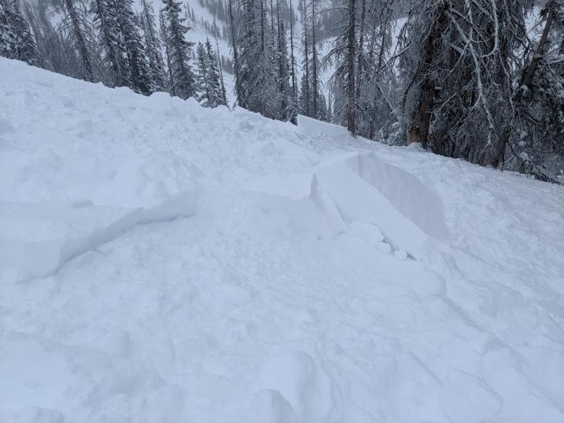
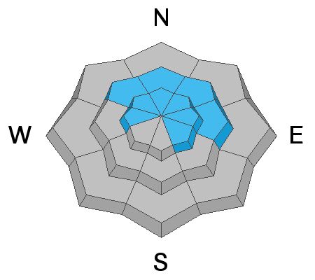
Making up a small portion of terrain available to ride in today, in the wind zone at and above treeline, you'll find pockets of CONSIDERABLE avalanche danger. Human triggered avalanches are LIKELY on steep wind drifted slopes, especially those with an easterly component to its aspect.
Even mid elevation, leeward terrain gets in on the act where you'll find reactive, yet more manageable fresh drifts and MODERATE avalanche danger. While predictably breaking at or below our skis, board, or sled, human triggered avalanches are POSSIBLE on steep slopes with recent deposits of wind drifted snow.
Lose some elevation, lose the wind, and encounter generally LOW avalanche danger.
Low
Moderate
Considerable
High
Extreme
Learn how to read the forecast here
Special Announcements
We know there is a lot of uncertainty regarding the Coronavirus, but the Utah Avalanche Center is planning to continue issuing regular avalanche forecasts into April.
Weather and Snow
Currently-
Skies are mostly cloudy, temperatures in the mid to upper 20's, and a scattered snow shower or two slides through the area this morning, stacking up an additional inch or two throughout the range. The bigger news are the southerly winds which began ramping up around 9:00 last night, cranking 40-60 mph along the high ridges. The good news is... recent storms vastly improved riding conditions and while it's a bit rugged getting there, wind sheltered mid elevation terrain offers soft, settled, cold snow.
Uinta weather network info is found here. Simply click on the Western Uinta tab.
For today-
Expect thinning clouds and a passing snow shower or two with high temperatures climbing into the upper 30's. Winds continue howling in the 50's and 60's, gusting into the 70's along the high ridges for a good portion of the day.
Futurecast-
Dry weather and decreasing winds are on tap for Monday and Tuesday with a complex weather system developing mid week. While we should see a good shot of snow, strength, timing, and details are still being ironed out.
Recent Avalanches
Michael J intentionally triggered this well connected soft slab along the leeward side of a steep wind drifted slope near Hoyt Peak... definitely big enough to let you know who's Boss (and I ain't talkin' Springsteen... yo :)
Mike's insight and great trip report from yesterday is found here.
To view additional trip reports and recent avalanche activity, simply click here.
Ad
Avalanche Problem #1
Wind Drifted Snow
Type
Location
Likelihood
Size
Description
24 hour wind data from Windy Peak (10,662') illustrating recent ridgetop winds.
It's crazy how a few inches of snow coupled with 24 hours of strong southerly winds, creates connected wind drifts along the leeward side of upper elevation ridges. As a matter of fact, yesterday's avalanche activity clearly punctuates this point.... and the winds were just beginning to blow!
So here's the deal- in the wind zone, today's drifts will break deeper and wider than you might expect and could easily slam you into a tree, instantly ruining your day
Now here's the good news.... recent drifts are easy to detect by their fat, rounded appearance. And even more good news... they're easy to avoid! Simply lose a little elevation, swing over to wind sheltered, low angle terrain, you lose the problem and have a great day of riding.
Additional Information
In mid elevation terrain, Chad found loose snow sluffs, manageable avalanche conditions, and great riding on wind sheltered slopes. His trip report is found here.
General Announcements
The information in this forecast expires in 24 hours, but will be updated by 7:00 AM Monday Mar. 16th.
This forecast is updated daily by 7:00 AM.
In the mean-time, if you see or trigger an avalanche or just wanna let me know what you're seeing you can reach me directly at 801-231-2170
The information in this forecast is from the US Forest Service which is solely responsible for its content.