March Kicks Off Our Spring Campaign- Donate Now to Support Forecasting

Forecast for the Uintas Area Mountains

Craig Gordon
Issued by Craig Gordon on
Saturday morning, March 14, 2020
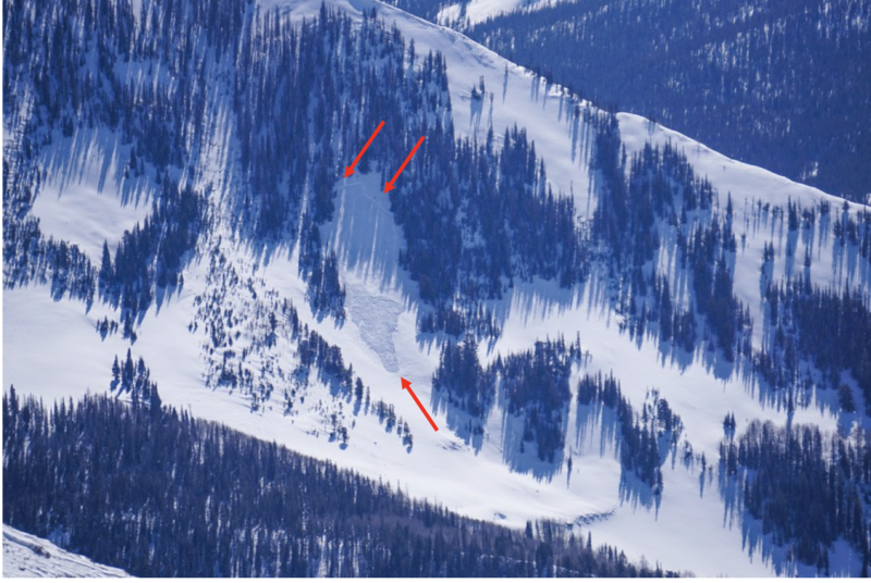
Making up a small portion of terrain available to ride on today, in the wind zone, you'll find pockets of MODERATE avalanche danger. Human triggered avalanches are possible on steep wind drifted slopes, especially those on the leeward side of ridges, at and above treeline. And here's something to consider... if you're getting into steep, technical terrain, even a small slide can knock you off your ride, slam you into a tree, and throw a curve ball at your day.
Lose a little elevation, you lose the wind, and encounter generally LOW avalanche danger.
Low
Moderate
Considerable
High
Extreme
Learn how to read the forecast here
Weather and Snow
Currently-
Yesterday's little storm overproduced, delivering an evenly distributed 4" of snow across the range. Overnight, skies cleared and temperatures dipped into the teens and low 20's. Right around midnight, southerly winds bumped into the 20 and 30's, with a few gusts in the 40's along the high peaks. It's a mixed bag of snow conditions. Up high you'll find dry, cold snow on north facing terrain, and sunny slopes at mid and low elevations offer solid, supportable corn-like surfaces.
Uinta weather network info is found here. Simply click on the Western Uinta tab.
For today-
Look for increasing clouds and scattered snow showers as a slow moving system brings unsettled weather to our area through this afternoon. High temperatures climb into the 30's and southerly winds crank into the 40's and 50's along the high ridges.
Futurecast-
Clearing skies overnight lead to a sunny Sunday with mild temperatures. Quiet weather is on tap for the beginning of the work week, but it looks like a stormy pattern is in store for the latter half of the week, though details are still being sorted through at the moment.
Recent Avalanches
From Thursday-
Guide, avy educator, and photographer extraordinaire, Shannon Finch spotted the mid slope avalanche in the image above in steep, shady terrain on Moffit Peak. Not particularly large, but definately big enough to let you know who's boss.
To view additional trip reports and recent avalanche activity, simply click here.
Ad
Avalanche Problem #1
Wind Drifted Snow
Type
Location
Likelihood
Size
Description
A few inches of snow coupled with strong southerly winds, creates pockety wind drifts along the leeward side of upper elevation ridges. Manageable in depth, size, and scope, today's fresh slabs are easy to detect by their fat, rounded appearance. And the good news is.... they're easy to avoid. Simply lose a little elevation, swing over to wind sheltered mid elevation terrain, and you lose the problem.
But remember- if you're tagging steep, technical terrain, be aware that even a small slide could knock you off your feet and boss you around.
General Announcements
The information in this forecast expires in 24 hours, but will be updated by 7:00 AM Sunday Mar. 15th.
This forecast is updated daily by 7:00 AM.
In the mean-time, if you see or trigger an avalanche or just wanna let me know what you're seeing you can reach me directly at 801-231-2170
This is a great time of year to schedule one of our free avy awareness presentations.
You can email me directly [email protected]
The information in this forecast is from the US Forest Service which is solely responsible for its content.