Forecast for the Ogden Area Mountains

Nikki Champion
Issued by Nikki Champion on
Wednesday morning, January 15, 2020
Today the avalanche danger is CONSIDERABLE on all mid and upper elevation slopes with recent deposits of wind drifted snow. Human triggered avalanches are likely with naturals possible, particularly with cornice failure. Avoid travel on and below steep slopes and in avalanche runout zones.
A MODERATE danger exists at low elevations where wind drifts can exist on isolated terrain features.
Today, look for signs of wind drifted at all elevations, and avoid those slopes.

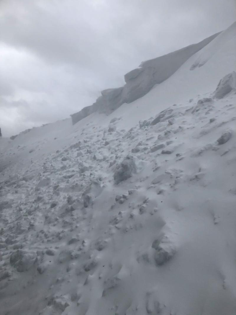
Cornices are large and growing. If traveling near a cornice, give them a lot of space both while traveling above them or below them. They can break back farther than expected, and/or trigger an adjacent wind drifted slope.
Low
Moderate
Considerable
High
Extreme
Learn how to read the forecast here
Special Announcements
Get discount lift tickets HERE. Thanks for this generous support from Utah Ski Resorts and Ski Utah. All proceeds go directly to supporting the UAC.
Weather and Snow
Since yesterday morning, another 3-5 inches of snow fell in the Ogden mountains. Strong west-southwest winds worked the ridgetops throughout the day with gusts nearly reaching 70 mph at Ogden Peak before dying down into the evening. Winds are currently northwesterly with gusts in the upper 20s at ridgetops. Temperatures are currently ranging from 5-15 F.
Today, we will get a break in the winds and snow. Winds will switch from northwest this morning to southwest this afternoon, averaging 10-25 mph, with gusts up to 40 mph near 11,000 ft. Skies will be partly cloudy. Temperatures will be in the mid-upper 20s F.
Looking forward, the next system will begin tomorrow evening into early Friday morning. We can expect another 4-8 inches of snow (.5 inches of water) and extremely high winds, hitting speeds near 80 mph at the upper elevations. Stay tuned.
Recent Avalanches
Yesterday no new avalanches were reported in the backcountry. At the ski resorts mitigation work was producing touchy cornice activity and soft slabs. Some of the wind slabs were reported as stubborn and unreactive in places.
I'd encourage you to look at all the details of the avalanches and observations, found in the Menu bar above.
Ad
Avalanche Problem #1
Wind Drifted Snow
Type
Location
Likelihood
Size
Description
Even though the winds have finally begun to die down, today wind slabs will continue to be on all aspects of the compass and likely human triggered on steep terrain and could continue to run naturally.
Everywhere I traveled yesterday in the Central Wasatch, every aspect and every elevation, from the trailhead to the ridgeline I was able to find signs of wind drifted snow. While the fresh slabs of wind drifted snow will be concentrated on upper elevation north-facing terrain, they will not be isolated to that terrain. The southwest winds worked the entire range, and heavily influenced mid-elevation slopes as well. Expect to find wind slabs at all mid and upper elevation slopes, and even steep wind loaded terrain features at low elevations.
The other tricky thing about this wind drifted snow is the varying sensitivity it could possess. Winds were howling yesterday, and with more snow available for transport we could have a soft slab, hard slab, soft slab sandwich on our hands. I would expect to see extremely soft slabs, easily triggered remotely from a distance in some areas and/or extremely firm, and stubborn hard slabs that are more difficult to trigger in others.
Today look for slopes with any signs of wind drifted snow, such as cracking, hollow sounds, and pillow-shaped snow, and avoiding those slopes.
A video Mark took north of Salt Lake in Bountiful of the wind drifted snow.

The CORNICES are getting huge, and just continue to grow. Yesterday while I was out I saw signs of growing cornices and signs of natural cornice release. These cornices are likely to continue releasing and could trigger adjacent wind slabs on steep slopes below. If traveling near a cornice, give them a wide berth as they will break back farther than expected if traveling above them and could naturally trigger an avalanche above you if traveling below them.
A photo of the large growing cornices from the Reynolds Ridgeline yesterday where they continue to release naturally.
General Announcements
This information does not apply to developed ski areas or highways where avalanche control is normally done. This forecast is from the U.S.D.A. Forest Service, which is solely responsible for its content. This forecast describes general avalanche conditions and local variations always occur.