Join us at our 2nd Annual Blizzard Ball

Forecast for the Ogden Area Mountains

Nikki Champion
Issued by Nikki Champion on
Thursday morning, January 16, 2020
The danger may not look much different from recent days, but recent strong winds have dramatically changed conditions. Today, look for signs of wind drifted at all elevations, and avoid those slopes.
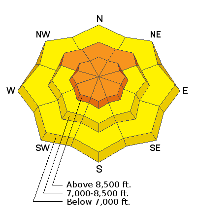
Today, a CONSIDERABLE avalanche danger exists on all upper elevation slopes, and north-facing mid-elevation slopes with recent deposits of wind drifted snow. Human triggered avalanches are likely with naturals possible, particularly with cornice failure. Large cornices have been falling and more should fall today with high winds and warm temperatures.

A MODERATE danger exists at east, west , and south-facing mid-elevation slopes and all low elevations where wind drifts can exist on isolated terrain features.

ROOF AVALANCHES - With so much snow on roofs in mountain valleys, warm temperatures may cause snow to slide off roofs. These can be deadly especially for children playing near a house. A few roof avalanches were reported in Big Cottonwood Canyon.
Low
Moderate
Considerable
High
Extreme
Learn how to read the forecast here
Special Announcements
Get discount lift tickets HERE. Thanks for this generous support from Utah Ski Resorts and Ski Utah. All proceeds go directly to supporting the UAC.
Weather and Snow
Mountain temperatures are currently in the upper-20s F at trailheads and mid-20s at ridgelines. The winds started to increase overnight and are currently south-southwesterly and averaging near 20 mph, with gusts up to 66 mph at Ogden Peak.
Today, both temperatures and winds should be high. Temperatures will reach the upper-30s F at trailheads and low-30s at ridgelines and winds will average 25-35 mph with gusts up to 80 mph during the day. As the winds increase throughout the day, the cloud cover will also build.
Tonight will bring the highest winds, near 90 mph before the approach of a strong cold front early tomorrow morning that will bring a switch in winds. Tomorrow morning should have high snowfall rates between 5 and 8 am with about 7-12 inches of snow falling tomorrow..
Recent Avalanches
In the backcountry a few naturals were noted in Willard, they appeared to be soft slabs of wind drifted snow that occurred sometime earlier in the week.
There was also a lot of large natural cornice fall noted in the backcountry, with some running 100-300’ feet.
No results reported with mitigation in the ski resorts.
You can find the full updated observation and avalanche list HERE.
Ad
Avalanche Problem #1
Wind Drifted Snow
Type
Location
Likelihood
Size
Description
The high winds are drifting snow and adding more stress to the snowpack. They will be increasing throughout the day until midnight tonight where they should reach gusts near 90 mph.
Yesterday the skies cleared, and the winds died down and we were able to see what had happened Monday. The entire range had been worked by the winds, and signs of wind drifted snow could be found at every aspect at every elevation band. Many slopes with slabs of wind drifted snow had been naturally triggered by cornice fall adjacent. Today I would continue to expect to find wind slabs at all upper elevation slopes and north, east and west-facing mid-elevation slopes. I would also expect to find some isolated wind slabs on south-facing mid-elevation slopes and steep wind loaded terrain features at low elevations.
As we add very high winds the south and westerly facing slopes will become increasingly scoured, and northerly and easterly slopes will continue to get loaded. These sustained strong winds have created stubborn hard slabs. These hard wind slabs can be more difficult to trigger meaning it could be the 4th or 5th skier on the slope that triggers an avalanche. They may also let you get further onto them before they break so that they break far around you.
While the high north-facing terrain will be most suspect very high winds can scour, swirl and impact unconventional areas. Zones that had previously been protected could begin to see signs of wind drifted snow at all elevation bands.
Today continue to look for slopes with any signs of wind drifted snow, such as cracking, hollow noises, and pillow-shaped snow and avoiding those slopes.
Avalanche Problem #2
Cornice
Type
Location
Likelihood
Size
Description
Yesterday multiple avalanches were reported from cornices naturally falling during high winds on Tuesday. Today the winds will increase, and temperatures will be warm this will cause the cornices to continue to grow and their stability will be tested.
Today's conditions make these cornices likely to continue releasing and could trigger adjacent wind slabs on steep slopes below them.
If traveling near a cornice at all today, give them plenty of space both above and below. They can break back farther than expected while traveling on a ridgeline and could naturally trigger an avalanche above you if traveling below a cornice.
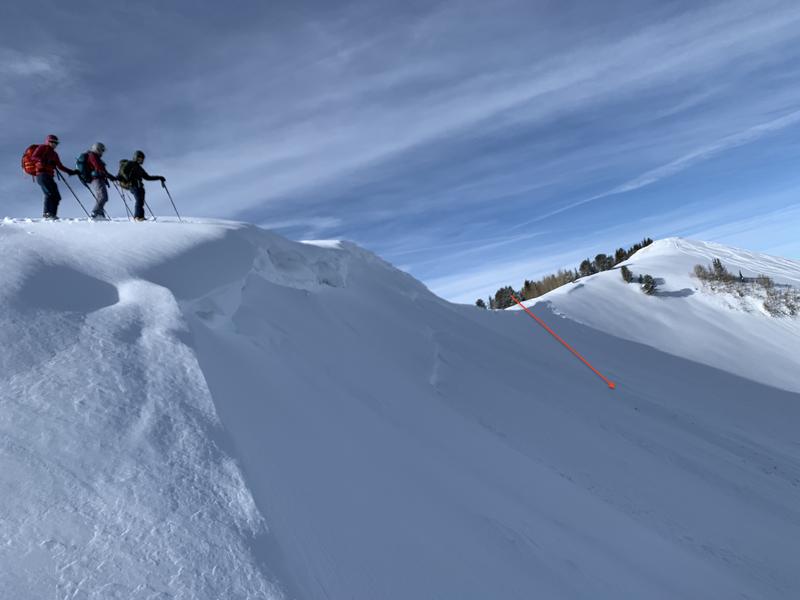
Photo below of a natural cornice failure in the Central Cottonwoods on S. Monitor that triggered the adjacent wind loaded slope below.
General Announcements
This information does not apply to developed ski areas or highways where avalanche control is normally done. This forecast is from the U.S.D.A. Forest Service, which is solely responsible for its content. This forecast describes general avalanche conditions and local variations always occur.