Forecast for the Salt Lake Area Mountains

Nikki Champion
Issued by Nikki Champion for
Thursday, January 2, 2020
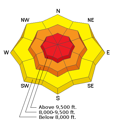
The avalanche danger is HIGH on all upper elevation slopes, CONSIDERABLE on all mid-elevation slopes and MODERATE on all lower elevation slopes.
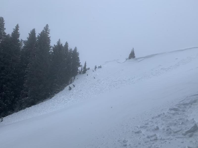
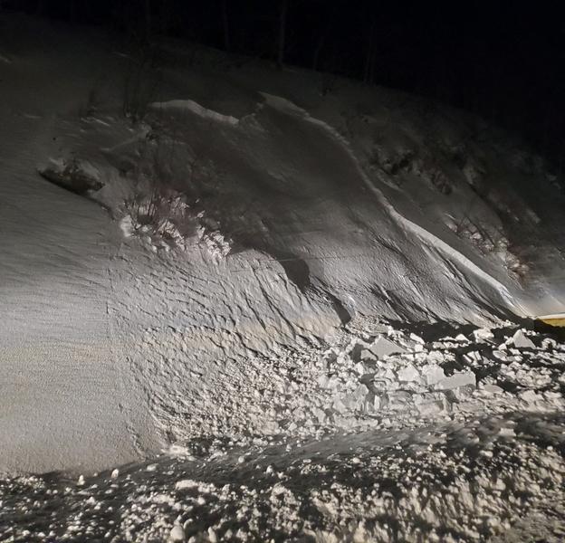
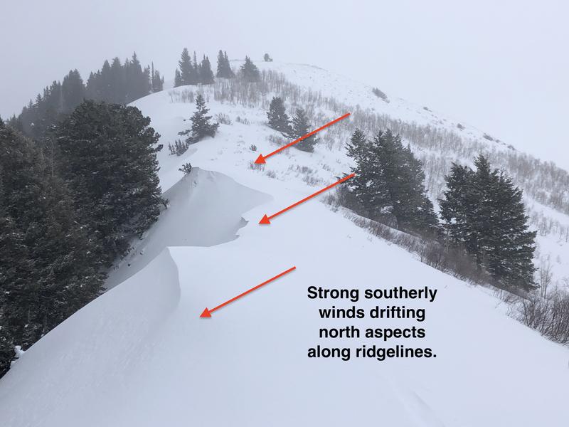
Today, both human-triggered and natural avalanches are likely at upper and mid elevations where heavy snowfall and strong winds, have created dangerous avalanche conditions especially on any slope with fresh wind drifts. Avalanches can also in the new snow unaffected by winds.
Cornices will continue to grow and become sensitive, so avoid traveling close to the edges of corniced ridges.
Low
Moderate
Considerable
High
Extreme
Learn how to read the forecast here
Special Announcements
Get discount lift tickets HERE. Thanks for this generous support from Utah Ski Resorts and Ski Utah. All proceeds go directly to supporting the UAC.

New to the backcountry or in need of a refresher? Consider taking a companion rescue course offered at Woodward Park City, January 14, 5:30-9 p.m.
Weather and Snow
This morning, mountain temperatures are in the upper teens F at trailheads and mid-teens F at ridgetops. Northwesterly winds deceased in the valley and trailheads but are still gusting into the upper 30s at ridgelines. Overnight another 5-10 inches of snow (0.5-1.25 inches of water) fell in the mountains. Storm totals since yesterday morning are 10-17 inches of snow (1-2 inches of water).
Today, the NW flow will continue to bring light snow showers into the morning before tapering off. Another 1-3" of snow (.05-.15 water) should fall this morning. Northwest winds will increase again this afternoon averaging 15-35 mph and gusting up to 60 mph at ridgelines. Temperatures should be in the mid-20s throughout the day.

The Alta Guard Station recorded 61" of snow for December with winter totals so far (Nov/Dec) at 149". The average is 162". Based on how the skiing and riding has been, it sure doesn't feel below average out there.
Recent Avalanches
Yesterday many sensitive soft slab and hard slabs of wind drifted snow avalanches occurred in the backcountry and the ski resorts. These avalanches included both human and natural triggered ones mostly above 9000 feet and breaking within the new snow. Many slides were triggered remotely, or from a distance, not by the skier on the slope. There were no reports of avalanches breaking deeper in the snowpack on a persistent weak layer near the ground.
This morning, and last night, a small natural cycle occurred in Little Cottonwood Canyon. These slides fractured at the new snow old snow interface on slopes with wind drifted snow.
Photo of a 2.5-foot deep wind slab triggered from 10-15' away on Murdock bowl (Photo: C. Brackelsberg)
Photo of natural wind slab in Little Cottonwood Canyon directly off the road (Photo. D. Richards). Similar avalanches were seen on the LCC cut banks by the plow drivers this morning.
Check out all of our observations HERE.
Ad
Avalanche Problem #1
Wind Drifted Snow
Type
Location
Likelihood
Size
Description
Winds have been strong, with some gusts nearing 100 mph at the highest ridgetops late last night. These powerful winds created wind drifts sensitive enough to avalanche naturally last night and into the early morning. With another 5-10" inches of snow overnight, winds will continue forming fresh wind drifts on top of ones formed yesterday. These drifts will be widespread near ridgelines at upper elevations but will also be found mid-elevations.
Today the winds will let up for a few hours but will increase again this afternoon. The wind drifts will continue to grow, become more firm and connected, and more sensitive as the winds continue. Look for signs of wind drifted snow, such as soft pillows, cracking, and whumping and avoid them.
Watch for sensitive cornices along upper elevation ridgelines, give cornices a wide berth as they can break back farther than expected.
Photo of wind drifted snow on a ridgeline in Butler Fork, look for these obvious clues and avoid being on wind drift. (Photo. G Gagne)
Avalanche Problem #2
New Snow
Type
Location
Likelihood
Size
Description
Before the coming storm, we had great, light, soft powder skiing. On top of that great light powder, this storm deposited heavy, wet, warm snow. This creates a dense slab of new snow on top of that weaker layer of snow. The continued snowfall will create sensitive new snow avalanches today, and these may even be triggered at a distance.
Human triggered avalanches are likely, as well as natural avalanches, especially at mid and upper elevations. Less snow fell at lower elevations but human triggered avalanches are possible. Pay attention to rapidly changing conditions, and watch for and avoid slopes with cracking, avalanching, even on smaller slopes.
The upper layers of the snowpack are like a game of Jenga in which we have removed the bottom pieces and just keep adding more to the top. Additional load, such as wind drifted snow and new snow will cause it to topple over and create an avalanche.

Avalanche Problem #3
Persistent Weak Layer
Type
Location
Likelihood
Size
Description
This layer has been mostly dormant and has been gaining strength, but it is not forgotten. This storm is a good test of this layer.
With enough snow and wind, it is possible that new avalanches may step down into the old persistent weak layer. An avalanche in the persistent weak layer is most likely on repeater avalanche paths, generally shallower snowpacks and in steep thin rocky terrain.
General Announcements
This information does not apply to developed ski areas or highways where avalanche control is normally done. This forecast is from the U.S.D.A. Forest Service, which is solely responsible for its content. This forecast describes general avalanche conditions and local variations always occur.