Join us at our 2nd Annual Blizzard Ball

Forecast for the Salt Lake Area Mountains

Drew Hardesty
Issued by Drew Hardesty on
Thursday morning, December 26, 2019
A MODERATE DANGER exists for human triggered sluff and storm slab avalanches on all aspects at the mid and upper elevations. Human triggered avalanches are possible. Be aware of other parties above or below you.
A pockety MODERATE DANGER ALSO EXISTS for triggering an avalanche 2-5' deep on northwest through east facing aspects. Continue to avoid steep rocky terrain as well as repeater slopes that have already avalanched this season.
Low
Moderate
Considerable
High
Extreme
Learn how to read the forecast here
Special Announcements
Thanks to the generous support of our Utah ski resorts and Ski Utah, we have discount lift tickets available. All proceeds from these go towards paying for avalanche forecasting and education! Get your tickets here.

Brighton Resort is closed to uphill traffic over the holiday period through January 1.
Weather and Snow
Light snow continues to fall in the mountains with most areas picking up another trace to 2" overnight. Storm totals since Monday eve are 15"/1.05"SWE in the upper Cottonwoods and about 10"/0.71"SWE along the Park City ridgeline.
Winds are hardly a whisper; temperatures are in the low teens.
Skiing and riding conditions? I'd say we made Santa's list this year. Somehow.
Recent Avalanches
The new snow ran with abandon on a variety of aspects and elevations yesterday but slope angles generally needed to push toward 40°. Guide Billy Haas described the avalanches as "long running medium volume high speed sluffs." Along with these sluffs were a few storm slabs 8-12" deep that mostly resisted wider propagation, but not all. See video below. Here, you'll see a snowboarder yesterday unintentionally trigger a storm slab in Dutch Draw roughly a foot deep and 150' wide. Yes, that Dutch Draw, the site of the fatality on the 15th and wingsuit skier triggered avalanche a couple days later. This avalanche yesterday was on east-northeast facing terrain at 10,000'. Mark and Nikki hope to investigate this avalanche today.
Larry Dunn noted another, more widely propagating (300' wide) natural storm snow avalanche in the Moonlight district of Mineral Fork of BCC on a steep northeast facing slope at 9500. (OBSERVATION)
Confused on locations? Check out the Wasatch Backcountry Skiing maps HERE.
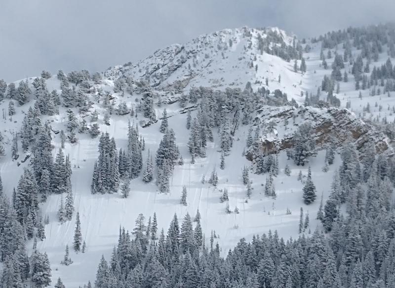
Most activity looked like the photo below. pc:Wilson
Ad
Avalanche Problem #1
New Snow
Type
Location
Likelihood
Size
Description
Human triggered point release and storm snow avalanches remain possible on all aspects at the mid and upper elevations. Weak interfaces included a spirited layer of stellar snow crystals running on hard wind crusts, density breaks, and in one case, preserved near surface facets prior to last weekend's wind event.
These slides can be problematic in steep, sustained terrain where the sluff and storm snow debris may pile up deeply. There's generally little mystery with these types of avalanches: they break at your feet or sled and respond to cornice drops and ski cuts. Keep an eye on your partners; carry and know how to use your rescue gear.
Danger Trend: Steady to Decreasing
Avalanche Problem #2
Persistent Weak Layer
Type
Location
Likelihood
Size
Description
A dangerous structure of a strong slab of snow over a persistent weak layer of faceted snow down near the ground exists on mid and upper elevation aspects facing northwest, through north, and east. Although this weak layer has become mostly dormant over the past week, several days of southerly winds over this past weekend and through Tuesday have created dense wind slabs on the aspects where this weak layer can be found. Additional stress to this suspect layering is the recent 12"+ of snow in the past couple days.
The most recent avalanche activity on this layering that we are aware of was overnight Saturday in South Monitor bowl along the Park City ridgeline (observation) in the Salt Lake mountains. This was a likely a cornice-triggered natural repeater (that is, this slope avalanched previously this season on the basal persistent weak layer of facets). The most recent non-repeater avalanches were on the 13th and 14th (Lake Martha Bowl, Figure 8 Hill, Twin Lakes).
Slopes that have a thinner and weaker snowpack are the most susceptible, this includes:
- steep rocky terrain;
- repeater slopes that have already avalanched this season (i.e. South Monitor).
If you choose to enter the terrain where this avalanche problem exists, consider the consequences of triggering one of these large avalanches.
Danger Trend: Steady to Decreasing

Additional Information
Moderate danger for both storm snow and deeper slab avalanches? Note the different avalanche behavior in the info-graphics for the two avalanche problems above -
The devil is in the details - here's the classic old school primer called Danger in the Danger Ratings.
The (slightly outdated) Avalanche Problem Toolbox helps to shed light on the different avalanche problems and travel advice for each. Thanks to Jim Conway for the graphic design.
General Announcements
This information does not apply to developed ski areas or highways where avalanche control is normally done. This forecast is from the U.S.D.A. Forest Service, which is solely responsible for its content. This forecast describes general avalanche conditions and local variations always occur.